Introduction guide to contextily#
Welcome to the taster guide for contextily, the package for contextual tiles in Python. In this notebook, we will show the basic functionality available in contextily, a package to work with web-tiles for background maps. To do that, we will use additional data to illustrate contextily can be integrated with other libraries such as geopandas and rasterio.
[1]:
%matplotlib inline

import contextily as cx
import geopandas
import rasterio
from rasterio.plot import show as rioshow
import matplotlib.pyplot as plt
from geodatasets import get_path
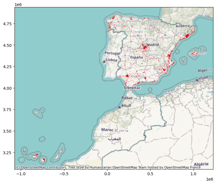
In this guide, we will use a delineation of urban areas in Spain proposed by Arribas-Bel, Garcia-Lopez & Viladecans-Marsal (2019) and available from:
[2]:
data_url = "https://ndownloader.figshare.com/files/20232174"
We car read it straight away:
[3]:
db = geopandas.read_file(data_url)
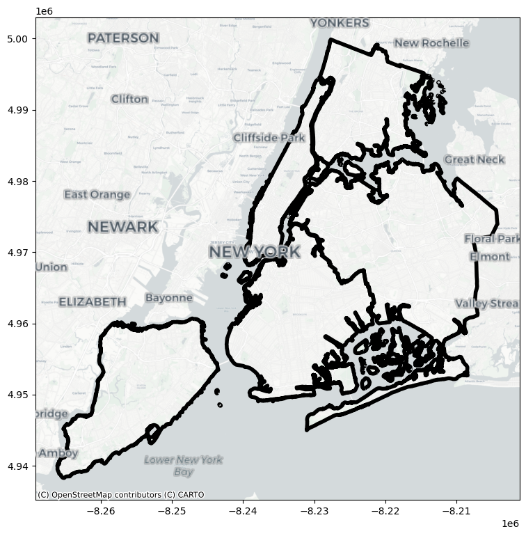
TL;DR#
The simplest way to access contextily and get a background map to go with your geographic data is to use the add_basemap method. Because the method takes a matplotlib axis, it is easy to integrate contextily with any other package for geospatial data that plots to matplotlib (e.g. rasterio, geopandas, etc.).
[4]:
ax = db.plot(color="red", figsize=(9, 9))
cx.add_basemap(ax, crs=db.crs)
Providers#
There is a whole host of providers, so you can switch easily between backgrounds:
[5]:
zaragoza = db.query("city_id == 'ci122'")
ax = zaragoza.plot(facecolor="none",
                   edgecolor="red",
                   linewidth=2
                  )
cx.add_basemap(ax,
               crs=zaragoza.crs.to_string(),
               source=cx.providers.CartoDB.Voyager
              )
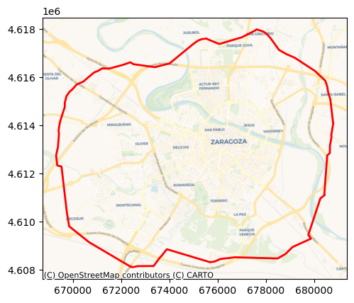
They are coming from `xyzservices <https://xyzservices.readthedocs.io/en/stable/>`__ as a xyzservices.Bunch object which makes them easy to explore within Python, especially in an interactive environment (like Jupyter).
[6]:
cx.providers
[6]:
-
xyzservices.Bunch7 items
-
xyzservices.TileProviderOpenStreetMap.Mapnik
- url
- https://tile.openstreetmap.org/{z}/{x}/{y}.png
- max_zoom
- 19
- html_attribution
- © OpenStreetMap contributors
- attribution
- (C) OpenStreetMap contributors
-
xyzservices.TileProviderOpenStreetMap.DE
- url
- https://tile.openstreetmap.de/{z}/{x}/{y}.png
- max_zoom
- 18
- html_attribution
- © OpenStreetMap contributors
- attribution
- (C) OpenStreetMap contributors
-
xyzservices.TileProviderOpenStreetMap.CH
- url
- https://tile.osm.ch/switzerland/{z}/{x}/{y}.png
- max_zoom
- 18
- html_attribution
- © OpenStreetMap contributors
- attribution
- (C) OpenStreetMap contributors
- bounds
- [[45, 5], [48, 11]]
-
xyzservices.TileProviderOpenStreetMap.France
- url
- https://{s}.tile.openstreetmap.fr/osmfr/{z}/{x}/{y}.png
- max_zoom
- 20
- html_attribution
- © OpenStreetMap France | © OpenStreetMap contributors
- attribution
- (C) OpenStreetMap France | (C) OpenStreetMap contributors
-
xyzservices.TileProviderOpenStreetMap.HOT
- url
- https://{s}.tile.openstreetmap.fr/hot/{z}/{x}/{y}.png
- max_zoom
- 19
- html_attribution
- © OpenStreetMap contributors, Tiles style by Humanitarian OpenStreetMap Team hosted by OpenStreetMap France
- attribution
- (C) OpenStreetMap contributors, Tiles style by Humanitarian OpenStreetMap Team hosted by OpenStreetMap France
-
xyzservices.TileProviderOpenStreetMap.BZH
- url
- https://tile.openstreetmap.bzh/br/{z}/{x}/{y}.png
- max_zoom
- 19
- html_attribution
- © OpenStreetMap contributors, Tiles courtesy of Breton OpenStreetMap Team
- attribution
- (C) OpenStreetMap contributors, Tiles courtesy of Breton OpenStreetMap Team
- bounds
- [[46.2, -5.5], [50, 0.7]]
-
xyzservices.TileProviderOpenStreetMap.BlackAndWhite
- url
- http://{s}.tiles.wmflabs.org/bw-mapnik/{z}/{x}/{y}.png
- max_zoom
- 18
- attribution
- (C) OpenStreetMap contributors
- html_attribution
- © OpenStreetMap contributors
-
-
xyzservices.Bunch3 items
-
xyzservices.TileProviderMapTilesAPI.OSMEnglish
- url
- https://maptiles.p.rapidapi.com/{variant}/{z}/{x}/{y}.png?rapidapi-key={apikey}
- html_attribution
- © MapTiles API, © OpenStreetMap contributors
- attribution
- (C) MapTiles API, (C) OpenStreetMap contributors
- variant
- en/map/v1
- apikey
- max_zoom
- 19
-
xyzservices.TileProviderMapTilesAPI.OSMFrancais
- url
- https://maptiles.p.rapidapi.com/{variant}/{z}/{x}/{y}.png?rapidapi-key={apikey}
- html_attribution
- © MapTiles API, © OpenStreetMap contributors
- attribution
- (C) MapTiles API, (C) OpenStreetMap contributors
- variant
- fr/map/v1
- apikey
- max_zoom
- 19
-
xyzservices.TileProviderMapTilesAPI.OSMEspagnol
- url
- https://maptiles.p.rapidapi.com/{variant}/{z}/{x}/{y}.png?rapidapi-key={apikey}
- html_attribution
- © MapTiles API, © OpenStreetMap contributors
- attribution
- (C) MapTiles API, (C) OpenStreetMap contributors
- variant
- es/map/v1
- apikey
- max_zoom
- 19
-
-
xyzservices.TileProviderOpenSeaMap
- url
- https://tiles.openseamap.org/seamark/{z}/{x}/{y}.png
- html_attribution
- Map data: © OpenSeaMap contributors
- attribution
- Map data: (C) OpenSeaMap contributors
-
xyzservices.TileProviderOPNVKarte
- url
- https://tileserver.memomaps.de/tilegen/{z}/{x}/{y}.png
- max_zoom
- 18
- html_attribution
- Map memomaps.de CC-BY-SA, map data © OpenStreetMap contributors
- attribution
- Map memomaps.de CC-BY-SA, map data (C) OpenStreetMap contributors
-
xyzservices.TileProviderOpenTopoMap
- url
- https://{s}.tile.opentopomap.org/{z}/{x}/{y}.png
- max_zoom
- 17
- html_attribution
- Map data: © OpenStreetMap contributors, SRTM | Map style: © OpenTopoMap (CC-BY-SA)
- attribution
- Map data: (C) OpenStreetMap contributors, SRTM | Map style: (C) OpenTopoMap (CC-BY-SA)
-
xyzservices.TileProviderOpenRailwayMap
- url
- https://{s}.tiles.openrailwaymap.org/standard/{z}/{x}/{y}.png
- max_zoom
- 19
- html_attribution
- Map data: © OpenStreetMap contributors | Map style: © OpenRailwayMap (CC-BY-SA)
- attribution
- Map data: (C) OpenStreetMap contributors | Map style: (C) OpenRailwayMap (CC-BY-SA)
-
xyzservices.TileProviderOpenFireMap
- url
- http://openfiremap.org/hytiles/{z}/{x}/{y}.png
- max_zoom
- 19
- html_attribution
- Map data: © OpenStreetMap contributors | Map style: © OpenFireMap (CC-BY-SA)
- attribution
- Map data: (C) OpenStreetMap contributors | Map style: (C) OpenFireMap (CC-BY-SA)
-
xyzservices.TileProviderSafeCast
- url
- https://s3.amazonaws.com/te512.safecast.org/{z}/{x}/{y}.png
- max_zoom
- 16
- html_attribution
- Map data: © OpenStreetMap contributors | Map style: © SafeCast (CC-BY-SA)
- attribution
- Map data: (C) OpenStreetMap contributors | Map style: (C) SafeCast (CC-BY-SA)
-
xyzservices.Bunch14 items
-
xyzservices.TileProviderStadia.AlidadeSmooth
- url
- https://tiles.stadiamaps.com/tiles/{variant}/{z}/{x}/{y}{r}.{ext}
- min_zoom
- 0
- max_zoom
- 20
- html_attribution
- © Stadia Maps © OpenMapTiles © OpenStreetMap contributors
- attribution
- (C) Stadia Maps (C) OpenMapTiles (C) OpenStreetMap contributors
- variant
- alidade_smooth
- ext
- png
-
xyzservices.TileProviderStadia.AlidadeSmoothDark
- url
- https://tiles.stadiamaps.com/tiles/{variant}/{z}/{x}/{y}{r}.{ext}
- min_zoom
- 0
- max_zoom
- 20
- html_attribution
- © Stadia Maps © OpenMapTiles © OpenStreetMap contributors
- attribution
- (C) Stadia Maps (C) OpenMapTiles (C) OpenStreetMap contributors
- variant
- alidade_smooth_dark
- ext
- png
-
xyzservices.TileProviderStadia.OSMBright
- url
- https://tiles.stadiamaps.com/tiles/{variant}/{z}/{x}/{y}{r}.{ext}
- min_zoom
- 0
- max_zoom
- 20
- html_attribution
- © Stadia Maps © OpenMapTiles © OpenStreetMap contributors
- attribution
- (C) Stadia Maps (C) OpenMapTiles (C) OpenStreetMap contributors
- variant
- osm_bright
- ext
- png
-
xyzservices.TileProviderStadia.Outdoors
- url
- https://tiles.stadiamaps.com/tiles/{variant}/{z}/{x}/{y}{r}.{ext}
- min_zoom
- 0
- max_zoom
- 20
- html_attribution
- © Stadia Maps © OpenMapTiles © OpenStreetMap contributors
- attribution
- (C) Stadia Maps (C) OpenMapTiles (C) OpenStreetMap contributors
- variant
- outdoors
- ext
- png
-
xyzservices.TileProviderStadia.StamenToner
- url
- https://tiles.stadiamaps.com/tiles/{variant}/{z}/{x}/{y}{r}.{ext}
- min_zoom
- 0
- max_zoom
- 20
- html_attribution
- © Stadia Maps © Stamen Design © OpenMapTiles © OpenStreetMap contributors
- attribution
- (C) Stadia Maps (C) Stamen Design (C) OpenMapTiles (C) OpenStreetMap contributors
- variant
- stamen_toner
- ext
- png
-
xyzservices.TileProviderStadia.StamenTonerBackground
- url
- https://tiles.stadiamaps.com/tiles/{variant}/{z}/{x}/{y}{r}.{ext}
- min_zoom
- 0
- max_zoom
- 20
- html_attribution
- © Stadia Maps © Stamen Design © OpenMapTiles © OpenStreetMap contributors
- attribution
- (C) Stadia Maps (C) Stamen Design (C) OpenMapTiles (C) OpenStreetMap contributors
- variant
- stamen_toner_background
- ext
- png
-
xyzservices.TileProviderStadia.StamenTonerLines
- url
- https://tiles.stadiamaps.com/tiles/{variant}/{z}/{x}/{y}{r}.{ext}
- min_zoom
- 0
- max_zoom
- 20
- html_attribution
- © Stadia Maps © Stamen Design © OpenMapTiles © OpenStreetMap contributors
- attribution
- (C) Stadia Maps (C) Stamen Design (C) OpenMapTiles (C) OpenStreetMap contributors
- variant
- stamen_toner_lines
- ext
- png
-
xyzservices.TileProviderStadia.StamenTonerLabels
- url
- https://tiles.stadiamaps.com/tiles/{variant}/{z}/{x}/{y}{r}.{ext}
- min_zoom
- 0
- max_zoom
- 20
- html_attribution
- © Stadia Maps © Stamen Design © OpenMapTiles © OpenStreetMap contributors
- attribution
- (C) Stadia Maps (C) Stamen Design (C) OpenMapTiles (C) OpenStreetMap contributors
- variant
- stamen_toner_labels
- ext
- png
-
xyzservices.TileProviderStadia.StamenTonerLite
- url
- https://tiles.stadiamaps.com/tiles/{variant}/{z}/{x}/{y}{r}.{ext}
- min_zoom
- 0
- max_zoom
- 20
- html_attribution
- © Stadia Maps © Stamen Design © OpenMapTiles © OpenStreetMap contributors
- attribution
- (C) Stadia Maps (C) Stamen Design (C) OpenMapTiles (C) OpenStreetMap contributors
- variant
- stamen_toner_lite
- ext
- png
-
xyzservices.TileProviderStadia.StamenWatercolor
- url
- https://tiles.stadiamaps.com/tiles/{variant}/{z}/{x}/{y}.{ext}
- min_zoom
- 1
- max_zoom
- 16
- html_attribution
- © Stadia Maps © Stamen Design © OpenMapTiles © OpenStreetMap contributors
- attribution
- (C) Stadia Maps (C) Stamen Design (C) OpenMapTiles (C) OpenStreetMap contributors
- variant
- stamen_watercolor
- ext
- jpg
-
xyzservices.TileProviderStadia.StamenTerrain
- url
- https://tiles.stadiamaps.com/tiles/{variant}/{z}/{x}/{y}{r}.{ext}
- min_zoom
- 0
- max_zoom
- 18
- html_attribution
- © Stadia Maps © Stamen Design © OpenMapTiles © OpenStreetMap contributors
- attribution
- (C) Stadia Maps (C) Stamen Design (C) OpenMapTiles (C) OpenStreetMap contributors
- variant
- stamen_terrain
- ext
- png
-
xyzservices.TileProviderStadia.StamenTerrainBackground
- url
- https://tiles.stadiamaps.com/tiles/{variant}/{z}/{x}/{y}{r}.{ext}
- min_zoom
- 0
- max_zoom
- 18
- html_attribution
- © Stadia Maps © Stamen Design © OpenMapTiles © OpenStreetMap contributors
- attribution
- (C) Stadia Maps (C) Stamen Design (C) OpenMapTiles (C) OpenStreetMap contributors
- variant
- stamen_terrain_background
- ext
- png
-
xyzservices.TileProviderStadia.StamenTerrainLabels
- url
- https://tiles.stadiamaps.com/tiles/{variant}/{z}/{x}/{y}{r}.{ext}
- min_zoom
- 0
- max_zoom
- 18
- html_attribution
- © Stadia Maps © Stamen Design © OpenMapTiles © OpenStreetMap contributors
- attribution
- (C) Stadia Maps (C) Stamen Design (C) OpenMapTiles (C) OpenStreetMap contributors
- variant
- stamen_terrain_labels
- ext
- png
-
xyzservices.TileProviderStadia.StamenTerrainLines
- url
- https://tiles.stadiamaps.com/tiles/{variant}/{z}/{x}/{y}{r}.{ext}
- min_zoom
- 0
- max_zoom
- 18
- html_attribution
- © Stadia Maps © Stamen Design © OpenMapTiles © OpenStreetMap contributors
- attribution
- (C) Stadia Maps (C) Stamen Design (C) OpenMapTiles (C) OpenStreetMap contributors
- variant
- stamen_terrain_lines
- ext
- png
-
-
xyzservices.Bunch9 items
-
xyzservices.TileProviderThunderforest.OpenCycleMap
- url
- https://{s}.tile.thunderforest.com/{variant}/{z}/{x}/{y}.png?apikey={apikey}
- html_attribution
- © Thunderforest, © OpenStreetMap contributors
- attribution
- (C) Thunderforest, (C) OpenStreetMap contributors
- variant
- cycle
- apikey
- max_zoom
- 22
-
xyzservices.TileProviderThunderforest.Transport
- url
- https://{s}.tile.thunderforest.com/{variant}/{z}/{x}/{y}.png?apikey={apikey}
- html_attribution
- © Thunderforest, © OpenStreetMap contributors
- attribution
- (C) Thunderforest, (C) OpenStreetMap contributors
- variant
- transport
- apikey
- max_zoom
- 22
-
xyzservices.TileProviderThunderforest.TransportDark
- url
- https://{s}.tile.thunderforest.com/{variant}/{z}/{x}/{y}.png?apikey={apikey}
- html_attribution
- © Thunderforest, © OpenStreetMap contributors
- attribution
- (C) Thunderforest, (C) OpenStreetMap contributors
- variant
- transport-dark
- apikey
- max_zoom
- 22
-
xyzservices.TileProviderThunderforest.SpinalMap
- url
- https://{s}.tile.thunderforest.com/{variant}/{z}/{x}/{y}.png?apikey={apikey}
- html_attribution
- © Thunderforest, © OpenStreetMap contributors
- attribution
- (C) Thunderforest, (C) OpenStreetMap contributors
- variant
- spinal-map
- apikey
- max_zoom
- 22
-
xyzservices.TileProviderThunderforest.Landscape
- url
- https://{s}.tile.thunderforest.com/{variant}/{z}/{x}/{y}.png?apikey={apikey}
- html_attribution
- © Thunderforest, © OpenStreetMap contributors
- attribution
- (C) Thunderforest, (C) OpenStreetMap contributors
- variant
- landscape
- apikey
- max_zoom
- 22
-
xyzservices.TileProviderThunderforest.Outdoors
- url
- https://{s}.tile.thunderforest.com/{variant}/{z}/{x}/{y}.png?apikey={apikey}
- html_attribution
- © Thunderforest, © OpenStreetMap contributors
- attribution
- (C) Thunderforest, (C) OpenStreetMap contributors
- variant
- outdoors
- apikey
- max_zoom
- 22
-
xyzservices.TileProviderThunderforest.Pioneer
- url
- https://{s}.tile.thunderforest.com/{variant}/{z}/{x}/{y}.png?apikey={apikey}
- html_attribution
- © Thunderforest, © OpenStreetMap contributors
- attribution
- (C) Thunderforest, (C) OpenStreetMap contributors
- variant
- pioneer
- apikey
- max_zoom
- 22
-
xyzservices.TileProviderThunderforest.MobileAtlas
- url
- https://{s}.tile.thunderforest.com/{variant}/{z}/{x}/{y}.png?apikey={apikey}
- html_attribution
- © Thunderforest, © OpenStreetMap contributors
- attribution
- (C) Thunderforest, (C) OpenStreetMap contributors
- variant
- mobile-atlas
- apikey
- max_zoom
- 22
-
xyzservices.TileProviderThunderforest.Neighbourhood
- url
- https://{s}.tile.thunderforest.com/{variant}/{z}/{x}/{y}.png?apikey={apikey}
- html_attribution
- © Thunderforest, © OpenStreetMap contributors
- attribution
- (C) Thunderforest, (C) OpenStreetMap contributors
- variant
- neighbourhood
- apikey
- max_zoom
- 22
-
-
xyzservices.TileProviderCyclOSM
- url
- https://{s}.tile-cyclosm.openstreetmap.fr/cyclosm/{z}/{x}/{y}.png
- max_zoom
- 20
- html_attribution
- CyclOSM | Map data: © OpenStreetMap contributors
- attribution
- CyclOSM | Map data: (C) OpenStreetMap contributors
-
xyzservices.Bunch6 items
-
xyzservices.TileProviderJawg.Streets
- url
- https://{s}.tile.jawg.io/{variant}/{z}/{x}/{y}{r}.png?access-token={accessToken}
- html_attribution
- © JawgMaps © OpenStreetMap contributors
- attribution
- (C) **Jawg** Maps (C) OpenStreetMap contributors
- min_zoom
- 0
- max_zoom
- 22
- subdomains
- abcd
- variant
- jawg-streets
- accessToken
-
xyzservices.TileProviderJawg.Terrain
- url
- https://{s}.tile.jawg.io/{variant}/{z}/{x}/{y}{r}.png?access-token={accessToken}
- html_attribution
- © JawgMaps © OpenStreetMap contributors
- attribution
- (C) **Jawg** Maps (C) OpenStreetMap contributors
- min_zoom
- 0
- max_zoom
- 22
- subdomains
- abcd
- variant
- jawg-terrain
- accessToken
-
xyzservices.TileProviderJawg.Sunny
- url
- https://{s}.tile.jawg.io/{variant}/{z}/{x}/{y}{r}.png?access-token={accessToken}
- html_attribution
- © JawgMaps © OpenStreetMap contributors
- attribution
- (C) **Jawg** Maps (C) OpenStreetMap contributors
- min_zoom
- 0
- max_zoom
- 22
- subdomains
- abcd
- variant
- jawg-sunny
- accessToken
-
xyzservices.TileProviderJawg.Dark
- url
- https://{s}.tile.jawg.io/{variant}/{z}/{x}/{y}{r}.png?access-token={accessToken}
- html_attribution
- © JawgMaps © OpenStreetMap contributors
- attribution
- (C) **Jawg** Maps (C) OpenStreetMap contributors
- min_zoom
- 0
- max_zoom
- 22
- subdomains
- abcd
- variant
- jawg-dark
- accessToken
-
xyzservices.TileProviderJawg.Light
- url
- https://{s}.tile.jawg.io/{variant}/{z}/{x}/{y}{r}.png?access-token={accessToken}
- html_attribution
- © JawgMaps © OpenStreetMap contributors
- attribution
- (C) **Jawg** Maps (C) OpenStreetMap contributors
- min_zoom
- 0
- max_zoom
- 22
- subdomains
- abcd
- variant
- jawg-light
- accessToken
-
xyzservices.TileProviderJawg.Matrix
- url
- https://{s}.tile.jawg.io/{variant}/{z}/{x}/{y}{r}.png?access-token={accessToken}
- html_attribution
- © JawgMaps © OpenStreetMap contributors
- attribution
- (C) **Jawg** Maps (C) OpenStreetMap contributors
- min_zoom
- 0
- max_zoom
- 22
- subdomains
- abcd
- variant
- jawg-matrix
- accessToken
-
-
xyzservices.TileProviderMapBox
- url
- https://api.mapbox.com/styles/v1/{id}/tiles/{z}/{x}/{y}{r}?access_token={accessToken}
- html_attribution
- © Mapbox © OpenStreetMap contributors Improve this map
- attribution
- (C) Mapbox (C) OpenStreetMap contributors Improve this map
- tileSize
- 512
- max_zoom
- 18
- zoomOffset
- -1
- id
- mapbox/streets-v11
- accessToken
-
xyzservices.Bunch15 items
-
xyzservices.TileProviderMapTiler.Streets
- url
- https://api.maptiler.com/maps/{variant}/{z}/{x}/{y}{r}.{ext}?key={key}
- html_attribution
- © MapTiler © OpenStreetMap contributors
- attribution
- (C) MapTiler (C) OpenStreetMap contributors
- variant
- streets
- ext
- png
- key
- tileSize
- 512
- zoomOffset
- -1
- min_zoom
- 0
- max_zoom
- 21
-
xyzservices.TileProviderMapTiler.Basic
- url
- https://api.maptiler.com/maps/{variant}/{z}/{x}/{y}{r}.{ext}?key={key}
- html_attribution
- © MapTiler © OpenStreetMap contributors
- attribution
- (C) MapTiler (C) OpenStreetMap contributors
- variant
- basic
- ext
- png
- key
- tileSize
- 512
- zoomOffset
- -1
- min_zoom
- 0
- max_zoom
- 21
-
xyzservices.TileProviderMapTiler.Bright
- url
- https://api.maptiler.com/maps/{variant}/{z}/{x}/{y}{r}.{ext}?key={key}
- html_attribution
- © MapTiler © OpenStreetMap contributors
- attribution
- (C) MapTiler (C) OpenStreetMap contributors
- variant
- bright
- ext
- png
- key
- tileSize
- 512
- zoomOffset
- -1
- min_zoom
- 0
- max_zoom
- 21
-
xyzservices.TileProviderMapTiler.Pastel
- url
- https://api.maptiler.com/maps/{variant}/{z}/{x}/{y}{r}.{ext}?key={key}
- html_attribution
- © MapTiler © OpenStreetMap contributors
- attribution
- (C) MapTiler (C) OpenStreetMap contributors
- variant
- pastel
- ext
- png
- key
- tileSize
- 512
- zoomOffset
- -1
- min_zoom
- 0
- max_zoom
- 21
-
xyzservices.TileProviderMapTiler.Positron
- url
- https://api.maptiler.com/maps/{variant}/{z}/{x}/{y}{r}.{ext}?key={key}
- html_attribution
- © MapTiler © OpenStreetMap contributors
- attribution
- (C) MapTiler (C) OpenStreetMap contributors
- variant
- positron
- ext
- png
- key
- tileSize
- 512
- zoomOffset
- -1
- min_zoom
- 0
- max_zoom
- 21
-
xyzservices.TileProviderMapTiler.Hybrid
- url
- https://api.maptiler.com/maps/{variant}/{z}/{x}/{y}{r}.{ext}?key={key}
- html_attribution
- © MapTiler © OpenStreetMap contributors
- attribution
- (C) MapTiler (C) OpenStreetMap contributors
- variant
- hybrid
- ext
- jpg
- key
- tileSize
- 512
- zoomOffset
- -1
- min_zoom
- 0
- max_zoom
- 21
-
xyzservices.TileProviderMapTiler.Toner
- url
- https://api.maptiler.com/maps/{variant}/{z}/{x}/{y}{r}.{ext}?key={key}
- html_attribution
- © MapTiler © OpenStreetMap contributors
- attribution
- (C) MapTiler (C) OpenStreetMap contributors
- variant
- toner
- ext
- png
- key
- tileSize
- 512
- zoomOffset
- -1
- min_zoom
- 0
- max_zoom
- 21
-
xyzservices.TileProviderMapTiler.Topo
- url
- https://api.maptiler.com/maps/{variant}/{z}/{x}/{y}{r}.{ext}?key={key}
- html_attribution
- © MapTiler © OpenStreetMap contributors
- attribution
- (C) MapTiler (C) OpenStreetMap contributors
- variant
- topo
- ext
- png
- key
- tileSize
- 512
- zoomOffset
- -1
- min_zoom
- 0
- max_zoom
- 21
-
xyzservices.TileProviderMapTiler.Voyager
- url
- https://api.maptiler.com/maps/{variant}/{z}/{x}/{y}{r}.{ext}?key={key}
- html_attribution
- © MapTiler © OpenStreetMap contributors
- attribution
- (C) MapTiler (C) OpenStreetMap contributors
- variant
- voyager
- ext
- png
- key
- tileSize
- 512
- zoomOffset
- -1
- min_zoom
- 0
- max_zoom
- 21
-
xyzservices.TileProviderMapTiler.Basic4326
- url
- https://api.maptiler.com/maps/{variant}/{z}/{x}/{y}{r}.{ext}?key={key}
- html_attribution
- © MapTiler © OpenStreetMap contributors
- attribution
- (C) MapTiler (C) OpenStreetMap contributors
- variant
- basic-4326
- ext
- png
- key
- tileSize
- 512
- zoomOffset
- -1
- min_zoom
- 0
- max_zoom
- 21
- crs
- EPSG:4326
-
xyzservices.TileProviderMapTiler.Outdoor
- url
- https://api.maptiler.com/maps/{variant}/{z}/{x}/{y}{r}.{ext}?key={key}
- html_attribution
- © MapTiler © OpenStreetMap contributors
- attribution
- (C) MapTiler (C) OpenStreetMap contributors
- variant
- outdoor
- ext
- png
- key
- tileSize
- 512
- zoomOffset
- -1
- min_zoom
- 0
- max_zoom
- 21
-
xyzservices.TileProviderMapTiler.Topographique
- url
- https://api.maptiler.com/maps/{variant}/{z}/{x}/{y}{r}.{ext}?key={key}
- html_attribution
- © MapTiler © OpenStreetMap contributors
- attribution
- (C) MapTiler (C) OpenStreetMap contributors
- variant
- topographique
- ext
- png
- key
- tileSize
- 512
- zoomOffset
- -1
- min_zoom
- 0
- max_zoom
- 21
-
xyzservices.TileProviderMapTiler.Winter
- url
- https://api.maptiler.com/maps/{variant}/{z}/{x}/{y}{r}.{ext}?key={key}
- html_attribution
- © MapTiler © OpenStreetMap contributors
- attribution
- (C) MapTiler (C) OpenStreetMap contributors
- variant
- winter
- ext
- png
- key
- tileSize
- 512
- zoomOffset
- -1
- min_zoom
- 0
- max_zoom
- 21
-
xyzservices.TileProviderMapTiler.Satellite
- url
- https://api.maptiler.com/tiles/{variant}/{z}/{x}/{y}.{ext}?key={key}
- html_attribution
- © MapTiler © OpenStreetMap contributors
- attribution
- (C) MapTiler (C) OpenStreetMap contributors
- variant
- satellite-v2
- ext
- jpg
- key
- min_zoom
- 0
- max_zoom
- 20
-
xyzservices.TileProviderMapTiler.Terrain
- url
- https://api.maptiler.com/tiles/{variant}/{z}/{x}/{y}.{ext}?key={key}
- html_attribution
- © MapTiler © OpenStreetMap contributors
- attribution
- (C) MapTiler (C) OpenStreetMap contributors
- variant
- terrain-rgb
- ext
- png
- key
- min_zoom
- 0
- max_zoom
- 12
-
-
xyzservices.Bunch3 items
-
xyzservices.TileProviderTomTom.Basic
- url
- https://{s}.api.tomtom.com/map/1/tile/{variant}/{style}/{z}/{x}/{y}.{ext}?key={apikey}
- variant
- basic
- max_zoom
- 22
- html_attribution
- © 1992 - 2023 TomTom.
- attribution
- (C) 1992 - 2023 TomTom.
- subdomains
- abcd
- style
- main
- ext
- png
- apikey
-
xyzservices.TileProviderTomTom.Hybrid
- url
- https://{s}.api.tomtom.com/map/1/tile/{variant}/{style}/{z}/{x}/{y}.{ext}?key={apikey}
- variant
- hybrid
- max_zoom
- 22
- html_attribution
- © 1992 - 2023 TomTom.
- attribution
- (C) 1992 - 2023 TomTom.
- subdomains
- abcd
- style
- main
- ext
- png
- apikey
-
xyzservices.TileProviderTomTom.Labels
- url
- https://{s}.api.tomtom.com/map/1/tile/{variant}/{style}/{z}/{x}/{y}.{ext}?key={apikey}
- variant
- labels
- max_zoom
- 22
- html_attribution
- © 1992 - 2023 TomTom.
- attribution
- (C) 1992 - 2023 TomTom.
- subdomains
- abcd
- style
- main
- ext
- png
- apikey
-
-
xyzservices.Bunch15 items
-
xyzservices.TileProviderEsri.WorldStreetMap
- url
- https://server.arcgisonline.com/ArcGIS/rest/services/{variant}/MapServer/tile/{z}/{y}/{x}
- variant
- World_Street_Map
- html_attribution
- Tiles © Esri — Source: Esri, DeLorme, NAVTEQ, USGS, Intermap, iPC, NRCAN, Esri Japan, METI, Esri China (Hong Kong), Esri (Thailand), TomTom, 2012
- attribution
- Tiles (C) Esri -- Source: Esri, DeLorme, NAVTEQ, USGS, Intermap, iPC, NRCAN, Esri Japan, METI, Esri China (Hong Kong), Esri (Thailand), TomTom, 2012
-
xyzservices.TileProviderEsri.DeLorme
- url
- https://server.arcgisonline.com/ArcGIS/rest/services/{variant}/MapServer/tile/{z}/{y}/{x}
- variant
- Specialty/DeLorme_World_Base_Map
- html_attribution
- Tiles © Esri — Copyright: ©2012 DeLorme
- attribution
- Tiles (C) Esri -- Copyright: (C)2012 DeLorme
- min_zoom
- 1
- max_zoom
- 11
-
xyzservices.TileProviderEsri.WorldTopoMap
- url
- https://server.arcgisonline.com/ArcGIS/rest/services/{variant}/MapServer/tile/{z}/{y}/{x}
- variant
- World_Topo_Map
- html_attribution
- Tiles © Esri — Esri, DeLorme, NAVTEQ, TomTom, Intermap, iPC, USGS, FAO, NPS, NRCAN, GeoBase, Kadaster NL, Ordnance Survey, Esri Japan, METI, Esri China (Hong Kong), and the GIS User Community
- attribution
- Tiles (C) Esri -- Esri, DeLorme, NAVTEQ, TomTom, Intermap, iPC, USGS, FAO, NPS, NRCAN, GeoBase, Kadaster NL, Ordnance Survey, Esri Japan, METI, Esri China (Hong Kong), and the GIS User Community
-
xyzservices.TileProviderEsri.WorldImagery
- url
- https://server.arcgisonline.com/ArcGIS/rest/services/{variant}/MapServer/tile/{z}/{y}/{x}
- variant
- World_Imagery
- html_attribution
- Tiles © Esri — Source: Esri, i-cubed, USDA, USGS, AEX, GeoEye, Getmapping, Aerogrid, IGN, IGP, UPR-EGP, and the GIS User Community
- attribution
- Tiles (C) Esri -- Source: Esri, i-cubed, USDA, USGS, AEX, GeoEye, Getmapping, Aerogrid, IGN, IGP, UPR-EGP, and the GIS User Community
-
xyzservices.TileProviderEsri.WorldTerrain
- url
- https://server.arcgisonline.com/ArcGIS/rest/services/{variant}/MapServer/tile/{z}/{y}/{x}
- variant
- World_Terrain_Base
- html_attribution
- Tiles © Esri — Source: USGS, Esri, TANA, DeLorme, and NPS
- attribution
- Tiles (C) Esri -- Source: USGS, Esri, TANA, DeLorme, and NPS
- max_zoom
- 13
-
xyzservices.TileProviderEsri.WorldShadedRelief
- url
- https://server.arcgisonline.com/ArcGIS/rest/services/{variant}/MapServer/tile/{z}/{y}/{x}
- variant
- World_Shaded_Relief
- html_attribution
- Tiles © Esri — Source: Esri
- attribution
- Tiles (C) Esri -- Source: Esri
- max_zoom
- 13
-
xyzservices.TileProviderEsri.WorldPhysical
- url
- https://server.arcgisonline.com/ArcGIS/rest/services/{variant}/MapServer/tile/{z}/{y}/{x}
- variant
- World_Physical_Map
- html_attribution
- Tiles © Esri — Source: US National Park Service
- attribution
- Tiles (C) Esri -- Source: US National Park Service
- max_zoom
- 8
-
xyzservices.TileProviderEsri.OceanBasemap
- url
- https://server.arcgisonline.com/ArcGIS/rest/services/{variant}/MapServer/tile/{z}/{y}/{x}
- variant
- Ocean/World_Ocean_Base
- html_attribution
- Tiles © Esri — Sources: GEBCO, NOAA, CHS, OSU, UNH, CSUMB, National Geographic, DeLorme, NAVTEQ, and Esri
- attribution
- Tiles (C) Esri -- Sources: GEBCO, NOAA, CHS, OSU, UNH, CSUMB, National Geographic, DeLorme, NAVTEQ, and Esri
- max_zoom
- 13
-
xyzservices.TileProviderEsri.NatGeoWorldMap
- url
- https://server.arcgisonline.com/ArcGIS/rest/services/{variant}/MapServer/tile/{z}/{y}/{x}
- variant
- NatGeo_World_Map
- html_attribution
- Tiles © Esri — National Geographic, Esri, DeLorme, NAVTEQ, UNEP-WCMC, USGS, NASA, ESA, METI, NRCAN, GEBCO, NOAA, iPC
- attribution
- Tiles (C) Esri -- National Geographic, Esri, DeLorme, NAVTEQ, UNEP-WCMC, USGS, NASA, ESA, METI, NRCAN, GEBCO, NOAA, iPC
- max_zoom
- 16
-
xyzservices.TileProviderEsri.WorldGrayCanvas
- url
- https://server.arcgisonline.com/ArcGIS/rest/services/{variant}/MapServer/tile/{z}/{y}/{x}
- variant
- Canvas/World_Light_Gray_Base
- html_attribution
- Tiles © Esri — Esri, DeLorme, NAVTEQ
- attribution
- Tiles (C) Esri -- Esri, DeLorme, NAVTEQ
- max_zoom
- 16
-
xyzservices.TileProviderEsri.ArcticImagery
- url
- http://server.arcgisonline.com/ArcGIS/rest/services/Polar/Arctic_Imagery/MapServer/tile/{z}/{y}/{x}
- variant
- Arctic_Imagery
- html_attribution
- Earthstar Geographics
- attribution
- Earthstar Geographics
- max_zoom
- 24
- crs
- EPSG:5936
- bounds
- [[-2623285.8808999993, -2623285.8808999993], [6623285.8803, 6623285.8803]]
-
xyzservices.TileProviderEsri.ArcticOceanBase
- url
- http://server.arcgisonline.com/ArcGIS/rest/services/Polar/Arctic_Ocean_Base/MapServer/tile/{z}/{y}/{x}
- variant
- Arctic_Ocean_Base
- html_attribution
- Tiles © Esri — Esri, DeLorme, NAVTEQ, TomTom, Intermap, iPC, USGS, FAO, NPS, NRCAN, GeoBase, Kadaster NL, Ordnance Survey, Esri Japan, METI, Esri China (Hong Kong), and the GIS User Community
- attribution
- Tiles © Esri — Esri, DeLorme, NAVTEQ, TomTom, Intermap, iPC, USGS, FAO, NPS, NRCAN, GeoBase, Kadaster NL, Ordnance Survey, Esri Japan, METI, Esri China (Hong Kong), and the GIS User Community
- max_zoom
- 24
- crs
- EPSG:5936
- bounds
- [[-2623285.8808999993, -2623285.8808999993], [6623285.8803, 6623285.8803]]
-
xyzservices.TileProviderEsri.ArcticOceanReference
- url
- http://server.arcgisonline.com/ArcGIS/rest/services/Polar/Arctic_Ocean_Reference/MapServer/tile/{z}/{y}/{x}
- variant
- Arctic_Ocean_Reference
- html_attribution
- Tiles © Esri — Esri, DeLorme, NAVTEQ, TomTom, Intermap, iPC, USGS, FAO, NPS, NRCAN, GeoBase, Kadaster NL, Ordnance Survey, Esri Japan, METI, Esri China (Hong Kong), and the GIS User Community
- attribution
- Tiles © Esri — Esri, DeLorme, NAVTEQ, TomTom, Intermap, iPC, USGS, FAO, NPS, NRCAN, GeoBase, Kadaster NL, Ordnance Survey, Esri Japan, METI, Esri China (Hong Kong), and the GIS User Community
- max_zoom
- 24
- crs
- EPSG:5936
- bounds
- [[-2623285.8808999993, -2623285.8808999993], [6623285.8803, 6623285.8803]]
-
xyzservices.TileProviderEsri.AntarcticImagery
- url
- http://server.arcgisonline.com/ArcGIS/rest/services/Polar/Antarctic_Imagery/MapServer/tile/{z}/{y}/{x}
- variant
- Antarctic_Imagery
- html_attribution
- Earthstar Geographics
- attribution
- Earthstar Geographics
- max_zoom
- 24
- crs
- EPSG:3031
- bounds
- [[-9913957.327914657, -5730886.461772691], [9913957.327914657, 5730886.461773157]]
-
xyzservices.TileProviderEsri.AntarcticBasemap
- url
- https://tiles.arcgis.com/tiles/C8EMgrsFcRFL6LrL/arcgis/rest/services/Antarctic_Basemap/MapServer/tile/{z}/{y}/{x}
- variant
- Antarctic_Basemap
- html_attribution
- Imagery provided by NOAA National Centers for Environmental Information (NCEI); International Bathymetric Chart of the Southern Ocean (IBCSO); General Bathymetric Chart of the Oceans (GEBCO).
- attribution
- Imagery provided by NOAA National Centers for Environmental Information (NCEI); International Bathymetric Chart of the Southern Ocean (IBCSO); General Bathymetric Chart of the Oceans (GEBCO).
- max_zoom
- 9
- crs
- EPSG:3031
- bounds
- [[-4524583.19363305, -4524449.487765655], [4524449.4877656475, 4524583.193633042]]
-
-
xyzservices.Bunch11 items
-
xyzservices.TileProviderOpenWeatherMap.Clouds
- url
- http://{s}.tile.openweathermap.org/map/{variant}/{z}/{x}/{y}.png?appid={apiKey}
- max_zoom
- 19
- html_attribution
- Map data © OpenWeatherMap
- attribution
- Map data (C) OpenWeatherMap
- apiKey
- opacity
- 0.5
- variant
- clouds
-
xyzservices.TileProviderOpenWeatherMap.CloudsClassic
- url
- http://{s}.tile.openweathermap.org/map/{variant}/{z}/{x}/{y}.png?appid={apiKey}
- max_zoom
- 19
- html_attribution
- Map data © OpenWeatherMap
- attribution
- Map data (C) OpenWeatherMap
- apiKey
- opacity
- 0.5
- variant
- clouds_cls
-
xyzservices.TileProviderOpenWeatherMap.Precipitation
- url
- http://{s}.tile.openweathermap.org/map/{variant}/{z}/{x}/{y}.png?appid={apiKey}
- max_zoom
- 19
- html_attribution
- Map data © OpenWeatherMap
- attribution
- Map data (C) OpenWeatherMap
- apiKey
- opacity
- 0.5
- variant
- precipitation
-
xyzservices.TileProviderOpenWeatherMap.PrecipitationClassic
- url
- http://{s}.tile.openweathermap.org/map/{variant}/{z}/{x}/{y}.png?appid={apiKey}
- max_zoom
- 19
- html_attribution
- Map data © OpenWeatherMap
- attribution
- Map data (C) OpenWeatherMap
- apiKey
- opacity
- 0.5
- variant
- precipitation_cls
-
xyzservices.TileProviderOpenWeatherMap.Rain
- url
- http://{s}.tile.openweathermap.org/map/{variant}/{z}/{x}/{y}.png?appid={apiKey}
- max_zoom
- 19
- html_attribution
- Map data © OpenWeatherMap
- attribution
- Map data (C) OpenWeatherMap
- apiKey
- opacity
- 0.5
- variant
- rain
-
xyzservices.TileProviderOpenWeatherMap.RainClassic
- url
- http://{s}.tile.openweathermap.org/map/{variant}/{z}/{x}/{y}.png?appid={apiKey}
- max_zoom
- 19
- html_attribution
- Map data © OpenWeatherMap
- attribution
- Map data (C) OpenWeatherMap
- apiKey
- opacity
- 0.5
- variant
- rain_cls
-
xyzservices.TileProviderOpenWeatherMap.Pressure
- url
- http://{s}.tile.openweathermap.org/map/{variant}/{z}/{x}/{y}.png?appid={apiKey}
- max_zoom
- 19
- html_attribution
- Map data © OpenWeatherMap
- attribution
- Map data (C) OpenWeatherMap
- apiKey
- opacity
- 0.5
- variant
- pressure
-
xyzservices.TileProviderOpenWeatherMap.PressureContour
- url
- http://{s}.tile.openweathermap.org/map/{variant}/{z}/{x}/{y}.png?appid={apiKey}
- max_zoom
- 19
- html_attribution
- Map data © OpenWeatherMap
- attribution
- Map data (C) OpenWeatherMap
- apiKey
- opacity
- 0.5
- variant
- pressure_cntr
-
xyzservices.TileProviderOpenWeatherMap.Wind
- url
- http://{s}.tile.openweathermap.org/map/{variant}/{z}/{x}/{y}.png?appid={apiKey}
- max_zoom
- 19
- html_attribution
- Map data © OpenWeatherMap
- attribution
- Map data (C) OpenWeatherMap
- apiKey
- opacity
- 0.5
- variant
- wind
-
xyzservices.TileProviderOpenWeatherMap.Temperature
- url
- http://{s}.tile.openweathermap.org/map/{variant}/{z}/{x}/{y}.png?appid={apiKey}
- max_zoom
- 19
- html_attribution
- Map data © OpenWeatherMap
- attribution
- Map data (C) OpenWeatherMap
- apiKey
- opacity
- 0.5
- variant
- temp
-
xyzservices.TileProviderOpenWeatherMap.Snow
- url
- http://{s}.tile.openweathermap.org/map/{variant}/{z}/{x}/{y}.png?appid={apiKey}
- max_zoom
- 19
- html_attribution
- Map data © OpenWeatherMap
- attribution
- Map data (C) OpenWeatherMap
- apiKey
- opacity
- 0.5
- variant
- snow
-
-
xyzservices.Bunch30 items
-
xyzservices.TileProviderHERE.normalDay
- url
- https://{s}.{base}.maps.api.here.com/maptile/2.1/{type}/{mapID}/{variant}/{z}/{x}/{y}/{size}/{format}?app_id={app_id}&app_code={app_code}&lg={language}
- html_attribution
- Map © 1987-2023 HERE
- attribution
- Map (C) 1987-2023 HERE
- subdomains
- 1234
- mapID
- newest
- app_id
- app_code
- base
- base
- variant
- normal.day
- max_zoom
- 20
- type
- maptile
- language
- eng
- format
- png8
- size
- 256
-
xyzservices.TileProviderHERE.normalDayCustom
- url
- https://{s}.{base}.maps.api.here.com/maptile/2.1/{type}/{mapID}/{variant}/{z}/{x}/{y}/{size}/{format}?app_id={app_id}&app_code={app_code}&lg={language}
- html_attribution
- Map © 1987-2023 HERE
- attribution
- Map (C) 1987-2023 HERE
- subdomains
- 1234
- mapID
- newest
- app_id
- app_code
- base
- base
- variant
- normal.day.custom
- max_zoom
- 20
- type
- maptile
- language
- eng
- format
- png8
- size
- 256
-
xyzservices.TileProviderHERE.normalDayGrey
- url
- https://{s}.{base}.maps.api.here.com/maptile/2.1/{type}/{mapID}/{variant}/{z}/{x}/{y}/{size}/{format}?app_id={app_id}&app_code={app_code}&lg={language}
- html_attribution
- Map © 1987-2023 HERE
- attribution
- Map (C) 1987-2023 HERE
- subdomains
- 1234
- mapID
- newest
- app_id
- app_code
- base
- base
- variant
- normal.day.grey
- max_zoom
- 20
- type
- maptile
- language
- eng
- format
- png8
- size
- 256
-
xyzservices.TileProviderHERE.normalDayMobile
- url
- https://{s}.{base}.maps.api.here.com/maptile/2.1/{type}/{mapID}/{variant}/{z}/{x}/{y}/{size}/{format}?app_id={app_id}&app_code={app_code}&lg={language}
- html_attribution
- Map © 1987-2023 HERE
- attribution
- Map (C) 1987-2023 HERE
- subdomains
- 1234
- mapID
- newest
- app_id
- app_code
- base
- base
- variant
- normal.day.mobile
- max_zoom
- 20
- type
- maptile
- language
- eng
- format
- png8
- size
- 256
-
xyzservices.TileProviderHERE.normalDayGreyMobile
- url
- https://{s}.{base}.maps.api.here.com/maptile/2.1/{type}/{mapID}/{variant}/{z}/{x}/{y}/{size}/{format}?app_id={app_id}&app_code={app_code}&lg={language}
- html_attribution
- Map © 1987-2023 HERE
- attribution
- Map (C) 1987-2023 HERE
- subdomains
- 1234
- mapID
- newest
- app_id
- app_code
- base
- base
- variant
- normal.day.grey.mobile
- max_zoom
- 20
- type
- maptile
- language
- eng
- format
- png8
- size
- 256
-
xyzservices.TileProviderHERE.normalDayTransit
- url
- https://{s}.{base}.maps.api.here.com/maptile/2.1/{type}/{mapID}/{variant}/{z}/{x}/{y}/{size}/{format}?app_id={app_id}&app_code={app_code}&lg={language}
- html_attribution
- Map © 1987-2023 HERE
- attribution
- Map (C) 1987-2023 HERE
- subdomains
- 1234
- mapID
- newest
- app_id
- app_code
- base
- base
- variant
- normal.day.transit
- max_zoom
- 20
- type
- maptile
- language
- eng
- format
- png8
- size
- 256
-
xyzservices.TileProviderHERE.normalDayTransitMobile
- url
- https://{s}.{base}.maps.api.here.com/maptile/2.1/{type}/{mapID}/{variant}/{z}/{x}/{y}/{size}/{format}?app_id={app_id}&app_code={app_code}&lg={language}
- html_attribution
- Map © 1987-2023 HERE
- attribution
- Map (C) 1987-2023 HERE
- subdomains
- 1234
- mapID
- newest
- app_id
- app_code
- base
- base
- variant
- normal.day.transit.mobile
- max_zoom
- 20
- type
- maptile
- language
- eng
- format
- png8
- size
- 256
-
xyzservices.TileProviderHERE.normalDayTraffic
- url
- https://{s}.{base}.maps.api.here.com/maptile/2.1/{type}/{mapID}/{variant}/{z}/{x}/{y}/{size}/{format}?app_id={app_id}&app_code={app_code}&lg={language}
- html_attribution
- Map © 1987-2023 HERE
- attribution
- Map (C) 1987-2023 HERE
- subdomains
- 1234
- mapID
- newest
- app_id
- app_code
- base
- traffic
- variant
- normal.traffic.day
- max_zoom
- 20
- type
- traffictile
- language
- eng
- format
- png8
- size
- 256
-
xyzservices.TileProviderHERE.normalNight
- url
- https://{s}.{base}.maps.api.here.com/maptile/2.1/{type}/{mapID}/{variant}/{z}/{x}/{y}/{size}/{format}?app_id={app_id}&app_code={app_code}&lg={language}
- html_attribution
- Map © 1987-2023 HERE
- attribution
- Map (C) 1987-2023 HERE
- subdomains
- 1234
- mapID
- newest
- app_id
- app_code
- base
- base
- variant
- normal.night
- max_zoom
- 20
- type
- maptile
- language
- eng
- format
- png8
- size
- 256
-
xyzservices.TileProviderHERE.normalNightMobile
- url
- https://{s}.{base}.maps.api.here.com/maptile/2.1/{type}/{mapID}/{variant}/{z}/{x}/{y}/{size}/{format}?app_id={app_id}&app_code={app_code}&lg={language}
- html_attribution
- Map © 1987-2023 HERE
- attribution
- Map (C) 1987-2023 HERE
- subdomains
- 1234
- mapID
- newest
- app_id
- app_code
- base
- base
- variant
- normal.night.mobile
- max_zoom
- 20
- type
- maptile
- language
- eng
- format
- png8
- size
- 256
-
xyzservices.TileProviderHERE.normalNightGrey
- url
- https://{s}.{base}.maps.api.here.com/maptile/2.1/{type}/{mapID}/{variant}/{z}/{x}/{y}/{size}/{format}?app_id={app_id}&app_code={app_code}&lg={language}
- html_attribution
- Map © 1987-2023 HERE
- attribution
- Map (C) 1987-2023 HERE
- subdomains
- 1234
- mapID
- newest
- app_id
- app_code
- base
- base
- variant
- normal.night.grey
- max_zoom
- 20
- type
- maptile
- language
- eng
- format
- png8
- size
- 256
-
xyzservices.TileProviderHERE.normalNightGreyMobile
- url
- https://{s}.{base}.maps.api.here.com/maptile/2.1/{type}/{mapID}/{variant}/{z}/{x}/{y}/{size}/{format}?app_id={app_id}&app_code={app_code}&lg={language}
- html_attribution
- Map © 1987-2023 HERE
- attribution
- Map (C) 1987-2023 HERE
- subdomains
- 1234
- mapID
- newest
- app_id
- app_code
- base
- base
- variant
- normal.night.grey.mobile
- max_zoom
- 20
- type
- maptile
- language
- eng
- format
- png8
- size
- 256
-
xyzservices.TileProviderHERE.normalNightTransit
- url
- https://{s}.{base}.maps.api.here.com/maptile/2.1/{type}/{mapID}/{variant}/{z}/{x}/{y}/{size}/{format}?app_id={app_id}&app_code={app_code}&lg={language}
- html_attribution
- Map © 1987-2023 HERE
- attribution
- Map (C) 1987-2023 HERE
- subdomains
- 1234
- mapID
- newest
- app_id
- app_code
- base
- base
- variant
- normal.night.transit
- max_zoom
- 20
- type
- maptile
- language
- eng
- format
- png8
- size
- 256
-
xyzservices.TileProviderHERE.normalNightTransitMobile
- url
- https://{s}.{base}.maps.api.here.com/maptile/2.1/{type}/{mapID}/{variant}/{z}/{x}/{y}/{size}/{format}?app_id={app_id}&app_code={app_code}&lg={language}
- html_attribution
- Map © 1987-2023 HERE
- attribution
- Map (C) 1987-2023 HERE
- subdomains
- 1234
- mapID
- newest
- app_id
- app_code
- base
- base
- variant
- normal.night.transit.mobile
- max_zoom
- 20
- type
- maptile
- language
- eng
- format
- png8
- size
- 256
-
xyzservices.TileProviderHERE.reducedDay
- url
- https://{s}.{base}.maps.api.here.com/maptile/2.1/{type}/{mapID}/{variant}/{z}/{x}/{y}/{size}/{format}?app_id={app_id}&app_code={app_code}&lg={language}
- html_attribution
- Map © 1987-2023 HERE
- attribution
- Map (C) 1987-2023 HERE
- subdomains
- 1234
- mapID
- newest
- app_id
- app_code
- base
- base
- variant
- reduced.day
- max_zoom
- 20
- type
- maptile
- language
- eng
- format
- png8
- size
- 256
-
xyzservices.TileProviderHERE.reducedNight
- url
- https://{s}.{base}.maps.api.here.com/maptile/2.1/{type}/{mapID}/{variant}/{z}/{x}/{y}/{size}/{format}?app_id={app_id}&app_code={app_code}&lg={language}
- html_attribution
- Map © 1987-2023 HERE
- attribution
- Map (C) 1987-2023 HERE
- subdomains
- 1234
- mapID
- newest
- app_id
- app_code
- base
- base
- variant
- reduced.night
- max_zoom
- 20
- type
- maptile
- language
- eng
- format
- png8
- size
- 256
-
xyzservices.TileProviderHERE.basicMap
- url
- https://{s}.{base}.maps.api.here.com/maptile/2.1/{type}/{mapID}/{variant}/{z}/{x}/{y}/{size}/{format}?app_id={app_id}&app_code={app_code}&lg={language}
- html_attribution
- Map © 1987-2023 HERE
- attribution
- Map (C) 1987-2023 HERE
- subdomains
- 1234
- mapID
- newest
- app_id
- app_code
- base
- base
- variant
- normal.day
- max_zoom
- 20
- type
- basetile
- language
- eng
- format
- png8
- size
- 256
-
xyzservices.TileProviderHERE.mapLabels
- url
- https://{s}.{base}.maps.api.here.com/maptile/2.1/{type}/{mapID}/{variant}/{z}/{x}/{y}/{size}/{format}?app_id={app_id}&app_code={app_code}&lg={language}
- html_attribution
- Map © 1987-2023 HERE
- attribution
- Map (C) 1987-2023 HERE
- subdomains
- 1234
- mapID
- newest
- app_id
- app_code
- base
- base
- variant
- normal.day
- max_zoom
- 20
- type
- labeltile
- language
- eng
- format
- png
- size
- 256
-
xyzservices.TileProviderHERE.trafficFlow
- url
- https://{s}.{base}.maps.api.here.com/maptile/2.1/{type}/{mapID}/{variant}/{z}/{x}/{y}/{size}/{format}?app_id={app_id}&app_code={app_code}&lg={language}
- html_attribution
- Map © 1987-2023 HERE
- attribution
- Map (C) 1987-2023 HERE
- subdomains
- 1234
- mapID
- newest
- app_id
- app_code
- base
- traffic
- variant
- normal.day
- max_zoom
- 20
- type
- flowtile
- language
- eng
- format
- png8
- size
- 256
-
xyzservices.TileProviderHERE.carnavDayGrey
- url
- https://{s}.{base}.maps.api.here.com/maptile/2.1/{type}/{mapID}/{variant}/{z}/{x}/{y}/{size}/{format}?app_id={app_id}&app_code={app_code}&lg={language}
- html_attribution
- Map © 1987-2023 HERE
- attribution
- Map (C) 1987-2023 HERE
- subdomains
- 1234
- mapID
- newest
- app_id
- app_code
- base
- base
- variant
- carnav.day.grey
- max_zoom
- 20
- type
- maptile
- language
- eng
- format
- png8
- size
- 256
-
xyzservices.TileProviderHERE.hybridDay
- url
- https://{s}.{base}.maps.api.here.com/maptile/2.1/{type}/{mapID}/{variant}/{z}/{x}/{y}/{size}/{format}?app_id={app_id}&app_code={app_code}&lg={language}
- html_attribution
- Map © 1987-2023 HERE
- attribution
- Map (C) 1987-2023 HERE
- subdomains
- 1234
- mapID
- newest
- app_id
- app_code
- base
- aerial
- variant
- hybrid.day
- max_zoom
- 20
- type
- maptile
- language
- eng
- format
- png8
- size
- 256
-
xyzservices.TileProviderHERE.hybridDayMobile
- url
- https://{s}.{base}.maps.api.here.com/maptile/2.1/{type}/{mapID}/{variant}/{z}/{x}/{y}/{size}/{format}?app_id={app_id}&app_code={app_code}&lg={language}
- html_attribution
- Map © 1987-2023 HERE
- attribution
- Map (C) 1987-2023 HERE
- subdomains
- 1234
- mapID
- newest
- app_id
- app_code
- base
- aerial
- variant
- hybrid.day.mobile
- max_zoom
- 20
- type
- maptile
- language
- eng
- format
- png8
- size
- 256
-
xyzservices.TileProviderHERE.hybridDayTransit
- url
- https://{s}.{base}.maps.api.here.com/maptile/2.1/{type}/{mapID}/{variant}/{z}/{x}/{y}/{size}/{format}?app_id={app_id}&app_code={app_code}&lg={language}
- html_attribution
- Map © 1987-2023 HERE
- attribution
- Map (C) 1987-2023 HERE
- subdomains
- 1234
- mapID
- newest
- app_id
- app_code
- base
- aerial
- variant
- hybrid.day.transit
- max_zoom
- 20
- type
- maptile
- language
- eng
- format
- png8
- size
- 256
-
xyzservices.TileProviderHERE.hybridDayGrey
- url
- https://{s}.{base}.maps.api.here.com/maptile/2.1/{type}/{mapID}/{variant}/{z}/{x}/{y}/{size}/{format}?app_id={app_id}&app_code={app_code}&lg={language}
- html_attribution
- Map © 1987-2023 HERE
- attribution
- Map (C) 1987-2023 HERE
- subdomains
- 1234
- mapID
- newest
- app_id
- app_code
- base
- aerial
- variant
- hybrid.grey.day
- max_zoom
- 20
- type
- maptile
- language
- eng
- format
- png8
- size
- 256
-
xyzservices.TileProviderHERE.hybridDayTraffic
- url
- https://{s}.{base}.maps.api.here.com/maptile/2.1/{type}/{mapID}/{variant}/{z}/{x}/{y}/{size}/{format}?app_id={app_id}&app_code={app_code}&lg={language}
- html_attribution
- Map © 1987-2023 HERE
- attribution
- Map (C) 1987-2023 HERE
- subdomains
- 1234
- mapID
- newest
- app_id
- app_code
- base
- traffic
- variant
- hybrid.traffic.day
- max_zoom
- 20
- type
- traffictile
- language
- eng
- format
- png8
- size
- 256
-
xyzservices.TileProviderHERE.pedestrianDay
- url
- https://{s}.{base}.maps.api.here.com/maptile/2.1/{type}/{mapID}/{variant}/{z}/{x}/{y}/{size}/{format}?app_id={app_id}&app_code={app_code}&lg={language}
- html_attribution
- Map © 1987-2023 HERE
- attribution
- Map (C) 1987-2023 HERE
- subdomains
- 1234
- mapID
- newest
- app_id
- app_code
- base
- base
- variant
- pedestrian.day
- max_zoom
- 20
- type
- maptile
- language
- eng
- format
- png8
- size
- 256
-
xyzservices.TileProviderHERE.pedestrianNight
- url
- https://{s}.{base}.maps.api.here.com/maptile/2.1/{type}/{mapID}/{variant}/{z}/{x}/{y}/{size}/{format}?app_id={app_id}&app_code={app_code}&lg={language}
- html_attribution
- Map © 1987-2023 HERE
- attribution
- Map (C) 1987-2023 HERE
- subdomains
- 1234
- mapID
- newest
- app_id
- app_code
- base
- base
- variant
- pedestrian.night
- max_zoom
- 20
- type
- maptile
- language
- eng
- format
- png8
- size
- 256
-
xyzservices.TileProviderHERE.satelliteDay
- url
- https://{s}.{base}.maps.api.here.com/maptile/2.1/{type}/{mapID}/{variant}/{z}/{x}/{y}/{size}/{format}?app_id={app_id}&app_code={app_code}&lg={language}
- html_attribution
- Map © 1987-2023 HERE
- attribution
- Map (C) 1987-2023 HERE
- subdomains
- 1234
- mapID
- newest
- app_id
- app_code
- base
- aerial
- variant
- satellite.day
- max_zoom
- 20
- type
- maptile
- language
- eng
- format
- png8
- size
- 256
-
xyzservices.TileProviderHERE.terrainDay
- url
- https://{s}.{base}.maps.api.here.com/maptile/2.1/{type}/{mapID}/{variant}/{z}/{x}/{y}/{size}/{format}?app_id={app_id}&app_code={app_code}&lg={language}
- html_attribution
- Map © 1987-2023 HERE
- attribution
- Map (C) 1987-2023 HERE
- subdomains
- 1234
- mapID
- newest
- app_id
- app_code
- base
- aerial
- variant
- terrain.day
- max_zoom
- 20
- type
- maptile
- language
- eng
- format
- png8
- size
- 256
-
xyzservices.TileProviderHERE.terrainDayMobile
- url
- https://{s}.{base}.maps.api.here.com/maptile/2.1/{type}/{mapID}/{variant}/{z}/{x}/{y}/{size}/{format}?app_id={app_id}&app_code={app_code}&lg={language}
- html_attribution
- Map © 1987-2023 HERE
- attribution
- Map (C) 1987-2023 HERE
- subdomains
- 1234
- mapID
- newest
- app_id
- app_code
- base
- aerial
- variant
- terrain.day.mobile
- max_zoom
- 20
- type
- maptile
- language
- eng
- format
- png8
- size
- 256
-
-
xyzservices.Bunch28 items
-
xyzservices.TileProviderHEREv3.normalDay
- url
- https://{s}.{base}.maps.ls.hereapi.com/maptile/2.1/{type}/{mapID}/{variant}/{z}/{x}/{y}/{size}/{format}?apiKey={apiKey}&lg={language}
- html_attribution
- Map © 1987-2023 HERE
- attribution
- Map (C) 1987-2023 HERE
- subdomains
- 1234
- mapID
- newest
- apiKey
- base
- base
- variant
- normal.day
- max_zoom
- 20
- type
- maptile
- language
- eng
- format
- png8
- size
- 256
-
xyzservices.TileProviderHEREv3.normalDayCustom
- url
- https://{s}.{base}.maps.ls.hereapi.com/maptile/2.1/{type}/{mapID}/{variant}/{z}/{x}/{y}/{size}/{format}?apiKey={apiKey}&lg={language}
- html_attribution
- Map © 1987-2023 HERE
- attribution
- Map (C) 1987-2023 HERE
- subdomains
- 1234
- mapID
- newest
- apiKey
- base
- base
- variant
- normal.day.custom
- max_zoom
- 20
- type
- maptile
- language
- eng
- format
- png8
- size
- 256
-
xyzservices.TileProviderHEREv3.normalDayGrey
- url
- https://{s}.{base}.maps.ls.hereapi.com/maptile/2.1/{type}/{mapID}/{variant}/{z}/{x}/{y}/{size}/{format}?apiKey={apiKey}&lg={language}
- html_attribution
- Map © 1987-2023 HERE
- attribution
- Map (C) 1987-2023 HERE
- subdomains
- 1234
- mapID
- newest
- apiKey
- base
- base
- variant
- normal.day.grey
- max_zoom
- 20
- type
- maptile
- language
- eng
- format
- png8
- size
- 256
-
xyzservices.TileProviderHEREv3.normalDayMobile
- url
- https://{s}.{base}.maps.ls.hereapi.com/maptile/2.1/{type}/{mapID}/{variant}/{z}/{x}/{y}/{size}/{format}?apiKey={apiKey}&lg={language}
- html_attribution
- Map © 1987-2023 HERE
- attribution
- Map (C) 1987-2023 HERE
- subdomains
- 1234
- mapID
- newest
- apiKey
- base
- base
- variant
- normal.day.mobile
- max_zoom
- 20
- type
- maptile
- language
- eng
- format
- png8
- size
- 256
-
xyzservices.TileProviderHEREv3.normalDayGreyMobile
- url
- https://{s}.{base}.maps.ls.hereapi.com/maptile/2.1/{type}/{mapID}/{variant}/{z}/{x}/{y}/{size}/{format}?apiKey={apiKey}&lg={language}
- html_attribution
- Map © 1987-2023 HERE
- attribution
- Map (C) 1987-2023 HERE
- subdomains
- 1234
- mapID
- newest
- apiKey
- base
- base
- variant
- normal.day.grey.mobile
- max_zoom
- 20
- type
- maptile
- language
- eng
- format
- png8
- size
- 256
-
xyzservices.TileProviderHEREv3.normalDayTransit
- url
- https://{s}.{base}.maps.ls.hereapi.com/maptile/2.1/{type}/{mapID}/{variant}/{z}/{x}/{y}/{size}/{format}?apiKey={apiKey}&lg={language}
- html_attribution
- Map © 1987-2023 HERE
- attribution
- Map (C) 1987-2023 HERE
- subdomains
- 1234
- mapID
- newest
- apiKey
- base
- base
- variant
- normal.day.transit
- max_zoom
- 20
- type
- maptile
- language
- eng
- format
- png8
- size
- 256
-
xyzservices.TileProviderHEREv3.normalDayTransitMobile
- url
- https://{s}.{base}.maps.ls.hereapi.com/maptile/2.1/{type}/{mapID}/{variant}/{z}/{x}/{y}/{size}/{format}?apiKey={apiKey}&lg={language}
- html_attribution
- Map © 1987-2023 HERE
- attribution
- Map (C) 1987-2023 HERE
- subdomains
- 1234
- mapID
- newest
- apiKey
- base
- base
- variant
- normal.day.transit.mobile
- max_zoom
- 20
- type
- maptile
- language
- eng
- format
- png8
- size
- 256
-
xyzservices.TileProviderHEREv3.normalNight
- url
- https://{s}.{base}.maps.ls.hereapi.com/maptile/2.1/{type}/{mapID}/{variant}/{z}/{x}/{y}/{size}/{format}?apiKey={apiKey}&lg={language}
- html_attribution
- Map © 1987-2023 HERE
- attribution
- Map (C) 1987-2023 HERE
- subdomains
- 1234
- mapID
- newest
- apiKey
- base
- base
- variant
- normal.night
- max_zoom
- 20
- type
- maptile
- language
- eng
- format
- png8
- size
- 256
-
xyzservices.TileProviderHEREv3.normalNightMobile
- url
- https://{s}.{base}.maps.ls.hereapi.com/maptile/2.1/{type}/{mapID}/{variant}/{z}/{x}/{y}/{size}/{format}?apiKey={apiKey}&lg={language}
- html_attribution
- Map © 1987-2023 HERE
- attribution
- Map (C) 1987-2023 HERE
- subdomains
- 1234
- mapID
- newest
- apiKey
- base
- base
- variant
- normal.night.mobile
- max_zoom
- 20
- type
- maptile
- language
- eng
- format
- png8
- size
- 256
-
xyzservices.TileProviderHEREv3.normalNightGrey
- url
- https://{s}.{base}.maps.ls.hereapi.com/maptile/2.1/{type}/{mapID}/{variant}/{z}/{x}/{y}/{size}/{format}?apiKey={apiKey}&lg={language}
- html_attribution
- Map © 1987-2023 HERE
- attribution
- Map (C) 1987-2023 HERE
- subdomains
- 1234
- mapID
- newest
- apiKey
- base
- base
- variant
- normal.night.grey
- max_zoom
- 20
- type
- maptile
- language
- eng
- format
- png8
- size
- 256
-
xyzservices.TileProviderHEREv3.normalNightGreyMobile
- url
- https://{s}.{base}.maps.ls.hereapi.com/maptile/2.1/{type}/{mapID}/{variant}/{z}/{x}/{y}/{size}/{format}?apiKey={apiKey}&lg={language}
- html_attribution
- Map © 1987-2023 HERE
- attribution
- Map (C) 1987-2023 HERE
- subdomains
- 1234
- mapID
- newest
- apiKey
- base
- base
- variant
- normal.night.grey.mobile
- max_zoom
- 20
- type
- maptile
- language
- eng
- format
- png8
- size
- 256
-
xyzservices.TileProviderHEREv3.normalNightTransit
- url
- https://{s}.{base}.maps.ls.hereapi.com/maptile/2.1/{type}/{mapID}/{variant}/{z}/{x}/{y}/{size}/{format}?apiKey={apiKey}&lg={language}
- html_attribution
- Map © 1987-2023 HERE
- attribution
- Map (C) 1987-2023 HERE
- subdomains
- 1234
- mapID
- newest
- apiKey
- base
- base
- variant
- normal.night.transit
- max_zoom
- 20
- type
- maptile
- language
- eng
- format
- png8
- size
- 256
-
xyzservices.TileProviderHEREv3.normalNightTransitMobile
- url
- https://{s}.{base}.maps.ls.hereapi.com/maptile/2.1/{type}/{mapID}/{variant}/{z}/{x}/{y}/{size}/{format}?apiKey={apiKey}&lg={language}
- html_attribution
- Map © 1987-2023 HERE
- attribution
- Map (C) 1987-2023 HERE
- subdomains
- 1234
- mapID
- newest
- apiKey
- base
- base
- variant
- normal.night.transit.mobile
- max_zoom
- 20
- type
- maptile
- language
- eng
- format
- png8
- size
- 256
-
xyzservices.TileProviderHEREv3.reducedDay
- url
- https://{s}.{base}.maps.ls.hereapi.com/maptile/2.1/{type}/{mapID}/{variant}/{z}/{x}/{y}/{size}/{format}?apiKey={apiKey}&lg={language}
- html_attribution
- Map © 1987-2023 HERE
- attribution
- Map (C) 1987-2023 HERE
- subdomains
- 1234
- mapID
- newest
- apiKey
- base
- base
- variant
- reduced.day
- max_zoom
- 20
- type
- maptile
- language
- eng
- format
- png8
- size
- 256
-
xyzservices.TileProviderHEREv3.reducedNight
- url
- https://{s}.{base}.maps.ls.hereapi.com/maptile/2.1/{type}/{mapID}/{variant}/{z}/{x}/{y}/{size}/{format}?apiKey={apiKey}&lg={language}
- html_attribution
- Map © 1987-2023 HERE
- attribution
- Map (C) 1987-2023 HERE
- subdomains
- 1234
- mapID
- newest
- apiKey
- base
- base
- variant
- reduced.night
- max_zoom
- 20
- type
- maptile
- language
- eng
- format
- png8
- size
- 256
-
xyzservices.TileProviderHEREv3.basicMap
- url
- https://{s}.{base}.maps.ls.hereapi.com/maptile/2.1/{type}/{mapID}/{variant}/{z}/{x}/{y}/{size}/{format}?apiKey={apiKey}&lg={language}
- html_attribution
- Map © 1987-2023 HERE
- attribution
- Map (C) 1987-2023 HERE
- subdomains
- 1234
- mapID
- newest
- apiKey
- base
- base
- variant
- normal.day
- max_zoom
- 20
- type
- basetile
- language
- eng
- format
- png8
- size
- 256
-
xyzservices.TileProviderHEREv3.mapLabels
- url
- https://{s}.{base}.maps.ls.hereapi.com/maptile/2.1/{type}/{mapID}/{variant}/{z}/{x}/{y}/{size}/{format}?apiKey={apiKey}&lg={language}
- html_attribution
- Map © 1987-2023 HERE
- attribution
- Map (C) 1987-2023 HERE
- subdomains
- 1234
- mapID
- newest
- apiKey
- base
- base
- variant
- normal.day
- max_zoom
- 20
- type
- labeltile
- language
- eng
- format
- png
- size
- 256
-
xyzservices.TileProviderHEREv3.trafficFlow
- url
- https://{s}.{base}.maps.ls.hereapi.com/maptile/2.1/{type}/{mapID}/{variant}/{z}/{x}/{y}/{size}/{format}?apiKey={apiKey}&lg={language}
- html_attribution
- Map © 1987-2023 HERE
- attribution
- Map (C) 1987-2023 HERE
- subdomains
- 1234
- mapID
- newest
- apiKey
- base
- traffic
- variant
- normal.day
- max_zoom
- 20
- type
- flowtile
- language
- eng
- format
- png8
- size
- 256
-
xyzservices.TileProviderHEREv3.carnavDayGrey
- url
- https://{s}.{base}.maps.ls.hereapi.com/maptile/2.1/{type}/{mapID}/{variant}/{z}/{x}/{y}/{size}/{format}?apiKey={apiKey}&lg={language}
- html_attribution
- Map © 1987-2023 HERE
- attribution
- Map (C) 1987-2023 HERE
- subdomains
- 1234
- mapID
- newest
- apiKey
- base
- base
- variant
- carnav.day.grey
- max_zoom
- 20
- type
- maptile
- language
- eng
- format
- png8
- size
- 256
-
xyzservices.TileProviderHEREv3.hybridDay
- url
- https://{s}.{base}.maps.ls.hereapi.com/maptile/2.1/{type}/{mapID}/{variant}/{z}/{x}/{y}/{size}/{format}?apiKey={apiKey}&lg={language}
- html_attribution
- Map © 1987-2023 HERE
- attribution
- Map (C) 1987-2023 HERE
- subdomains
- 1234
- mapID
- newest
- apiKey
- base
- aerial
- variant
- hybrid.day
- max_zoom
- 20
- type
- maptile
- language
- eng
- format
- png8
- size
- 256
-
xyzservices.TileProviderHEREv3.hybridDayMobile
- url
- https://{s}.{base}.maps.ls.hereapi.com/maptile/2.1/{type}/{mapID}/{variant}/{z}/{x}/{y}/{size}/{format}?apiKey={apiKey}&lg={language}
- html_attribution
- Map © 1987-2023 HERE
- attribution
- Map (C) 1987-2023 HERE
- subdomains
- 1234
- mapID
- newest
- apiKey
- base
- aerial
- variant
- hybrid.day.mobile
- max_zoom
- 20
- type
- maptile
- language
- eng
- format
- png8
- size
- 256
-
xyzservices.TileProviderHEREv3.hybridDayTransit
- url
- https://{s}.{base}.maps.ls.hereapi.com/maptile/2.1/{type}/{mapID}/{variant}/{z}/{x}/{y}/{size}/{format}?apiKey={apiKey}&lg={language}
- html_attribution
- Map © 1987-2023 HERE
- attribution
- Map (C) 1987-2023 HERE
- subdomains
- 1234
- mapID
- newest
- apiKey
- base
- aerial
- variant
- hybrid.day.transit
- max_zoom
- 20
- type
- maptile
- language
- eng
- format
- png8
- size
- 256
-
xyzservices.TileProviderHEREv3.hybridDayGrey
- url
- https://{s}.{base}.maps.ls.hereapi.com/maptile/2.1/{type}/{mapID}/{variant}/{z}/{x}/{y}/{size}/{format}?apiKey={apiKey}&lg={language}
- html_attribution
- Map © 1987-2023 HERE
- attribution
- Map (C) 1987-2023 HERE
- subdomains
- 1234
- mapID
- newest
- apiKey
- base
- aerial
- variant
- hybrid.grey.day
- max_zoom
- 20
- type
- maptile
- language
- eng
- format
- png8
- size
- 256
-
xyzservices.TileProviderHEREv3.pedestrianDay
- url
- https://{s}.{base}.maps.ls.hereapi.com/maptile/2.1/{type}/{mapID}/{variant}/{z}/{x}/{y}/{size}/{format}?apiKey={apiKey}&lg={language}
- html_attribution
- Map © 1987-2023 HERE
- attribution
- Map (C) 1987-2023 HERE
- subdomains
- 1234
- mapID
- newest
- apiKey
- base
- base
- variant
- pedestrian.day
- max_zoom
- 20
- type
- maptile
- language
- eng
- format
- png8
- size
- 256
-
xyzservices.TileProviderHEREv3.pedestrianNight
- url
- https://{s}.{base}.maps.ls.hereapi.com/maptile/2.1/{type}/{mapID}/{variant}/{z}/{x}/{y}/{size}/{format}?apiKey={apiKey}&lg={language}
- html_attribution
- Map © 1987-2023 HERE
- attribution
- Map (C) 1987-2023 HERE
- subdomains
- 1234
- mapID
- newest
- apiKey
- base
- base
- variant
- pedestrian.night
- max_zoom
- 20
- type
- maptile
- language
- eng
- format
- png8
- size
- 256
-
xyzservices.TileProviderHEREv3.satelliteDay
- url
- https://{s}.{base}.maps.ls.hereapi.com/maptile/2.1/{type}/{mapID}/{variant}/{z}/{x}/{y}/{size}/{format}?apiKey={apiKey}&lg={language}
- html_attribution
- Map © 1987-2023 HERE
- attribution
- Map (C) 1987-2023 HERE
- subdomains
- 1234
- mapID
- newest
- apiKey
- base
- aerial
- variant
- satellite.day
- max_zoom
- 20
- type
- maptile
- language
- eng
- format
- png8
- size
- 256
-
xyzservices.TileProviderHEREv3.terrainDay
- url
- https://{s}.{base}.maps.ls.hereapi.com/maptile/2.1/{type}/{mapID}/{variant}/{z}/{x}/{y}/{size}/{format}?apiKey={apiKey}&lg={language}
- html_attribution
- Map © 1987-2023 HERE
- attribution
- Map (C) 1987-2023 HERE
- subdomains
- 1234
- mapID
- newest
- apiKey
- base
- aerial
- variant
- terrain.day
- max_zoom
- 20
- type
- maptile
- language
- eng
- format
- png8
- size
- 256
-
xyzservices.TileProviderHEREv3.terrainDayMobile
- url
- https://{s}.{base}.maps.ls.hereapi.com/maptile/2.1/{type}/{mapID}/{variant}/{z}/{x}/{y}/{size}/{format}?apiKey={apiKey}&lg={language}
- html_attribution
- Map © 1987-2023 HERE
- attribution
- Map (C) 1987-2023 HERE
- subdomains
- 1234
- mapID
- newest
- apiKey
- base
- aerial
- variant
- terrain.day.mobile
- max_zoom
- 20
- type
- maptile
- language
- eng
- format
- png8
- size
- 256
-
-
xyzservices.TileProviderFreeMapSK
- url
- https://{s}.freemap.sk/T/{z}/{x}/{y}.jpeg
- min_zoom
- 8
- max_zoom
- 16
- subdomains
- abcd
- bounds
- [[47.204642, 15.996093], [49.830896, 22.576904]]
- html_attribution
- © OpenStreetMap contributors, visualization CC-By-SA 2.0 Freemap.sk
- attribution
- (C) OpenStreetMap contributors, visualization CC-By-SA 2.0 Freemap.sk
-
xyzservices.TileProviderMtbMap
- url
- http://tile.mtbmap.cz/mtbmap_tiles/{z}/{x}/{y}.png
- html_attribution
- © OpenStreetMap contributors & USGS
- attribution
- (C) OpenStreetMap contributors & USGS
-
xyzservices.Bunch10 items
-
xyzservices.TileProviderCartoDB.Positron
- url
- https://{s}.basemaps.cartocdn.com/{variant}/{z}/{x}/{y}{r}.png
- html_attribution
- © OpenStreetMap contributors © CARTO
- attribution
- (C) OpenStreetMap contributors (C) CARTO
- subdomains
- abcd
- max_zoom
- 20
- variant
- light_all
-
xyzservices.TileProviderCartoDB.PositronNoLabels
- url
- https://{s}.basemaps.cartocdn.com/{variant}/{z}/{x}/{y}{r}.png
- html_attribution
- © OpenStreetMap contributors © CARTO
- attribution
- (C) OpenStreetMap contributors (C) CARTO
- subdomains
- abcd
- max_zoom
- 20
- variant
- light_nolabels
-
xyzservices.TileProviderCartoDB.PositronOnlyLabels
- url
- https://{s}.basemaps.cartocdn.com/{variant}/{z}/{x}/{y}{r}.png
- html_attribution
- © OpenStreetMap contributors © CARTO
- attribution
- (C) OpenStreetMap contributors (C) CARTO
- subdomains
- abcd
- max_zoom
- 20
- variant
- light_only_labels
-
xyzservices.TileProviderCartoDB.DarkMatter
- url
- https://{s}.basemaps.cartocdn.com/{variant}/{z}/{x}/{y}{r}.png
- html_attribution
- © OpenStreetMap contributors © CARTO
- attribution
- (C) OpenStreetMap contributors (C) CARTO
- subdomains
- abcd
- max_zoom
- 20
- variant
- dark_all
-
xyzservices.TileProviderCartoDB.DarkMatterNoLabels
- url
- https://{s}.basemaps.cartocdn.com/{variant}/{z}/{x}/{y}{r}.png
- html_attribution
- © OpenStreetMap contributors © CARTO
- attribution
- (C) OpenStreetMap contributors (C) CARTO
- subdomains
- abcd
- max_zoom
- 20
- variant
- dark_nolabels
-
xyzservices.TileProviderCartoDB.DarkMatterOnlyLabels
- url
- https://{s}.basemaps.cartocdn.com/{variant}/{z}/{x}/{y}{r}.png
- html_attribution
- © OpenStreetMap contributors © CARTO
- attribution
- (C) OpenStreetMap contributors (C) CARTO
- subdomains
- abcd
- max_zoom
- 20
- variant
- dark_only_labels
-
xyzservices.TileProviderCartoDB.Voyager
- url
- https://{s}.basemaps.cartocdn.com/{variant}/{z}/{x}/{y}{r}.png
- html_attribution
- © OpenStreetMap contributors © CARTO
- attribution
- (C) OpenStreetMap contributors (C) CARTO
- subdomains
- abcd
- max_zoom
- 20
- variant
- rastertiles/voyager
-
xyzservices.TileProviderCartoDB.VoyagerNoLabels
- url
- https://{s}.basemaps.cartocdn.com/{variant}/{z}/{x}/{y}{r}.png
- html_attribution
- © OpenStreetMap contributors © CARTO
- attribution
- (C) OpenStreetMap contributors (C) CARTO
- subdomains
- abcd
- max_zoom
- 20
- variant
- rastertiles/voyager_nolabels
-
xyzservices.TileProviderCartoDB.VoyagerOnlyLabels
- url
- https://{s}.basemaps.cartocdn.com/{variant}/{z}/{x}/{y}{r}.png
- html_attribution
- © OpenStreetMap contributors © CARTO
- attribution
- (C) OpenStreetMap contributors (C) CARTO
- subdomains
- abcd
- max_zoom
- 20
- variant
- rastertiles/voyager_only_labels
-
xyzservices.TileProviderCartoDB.VoyagerLabelsUnder
- url
- https://{s}.basemaps.cartocdn.com/{variant}/{z}/{x}/{y}{r}.png
- html_attribution
- © OpenStreetMap contributors © CARTO
- attribution
- (C) OpenStreetMap contributors (C) CARTO
- subdomains
- abcd
- max_zoom
- 20
- variant
- rastertiles/voyager_labels_under
-
-
xyzservices.Bunch2 items
-
xyzservices.TileProviderHikeBike.HikeBike
- url
- https://tiles.wmflabs.org/{variant}/{z}/{x}/{y}.png
- max_zoom
- 19
- html_attribution
- © OpenStreetMap contributors
- attribution
- (C) OpenStreetMap contributors
- variant
- hikebike
-
xyzservices.TileProviderHikeBike.HillShading
- url
- https://tiles.wmflabs.org/{variant}/{z}/{x}/{y}.png
- max_zoom
- 15
- html_attribution
- © OpenStreetMap contributors
- attribution
- (C) OpenStreetMap contributors
- variant
- hillshading
-
-
xyzservices.Bunch7 items
-
xyzservices.TileProviderBasemapAT.basemap
- url
- https://mapsneu.wien.gv.at/basemap/{variant}/{type}/google3857/{z}/{y}/{x}.{format}
- max_zoom
- 20
- html_attribution
- Datenquelle: basemap.at
- attribution
- Datenquelle: basemap.at
- type
- normal
- format
- png
- bounds
- [[46.35877, 8.782379], [49.037872, 17.189532]]
- variant
- geolandbasemap
-
xyzservices.TileProviderBasemapAT.grau
- url
- https://mapsneu.wien.gv.at/basemap/{variant}/{type}/google3857/{z}/{y}/{x}.{format}
- max_zoom
- 19
- html_attribution
- Datenquelle: basemap.at
- attribution
- Datenquelle: basemap.at
- type
- normal
- format
- png
- bounds
- [[46.35877, 8.782379], [49.037872, 17.189532]]
- variant
- bmapgrau
-
xyzservices.TileProviderBasemapAT.overlay
- url
- https://mapsneu.wien.gv.at/basemap/{variant}/{type}/google3857/{z}/{y}/{x}.{format}
- max_zoom
- 19
- html_attribution
- Datenquelle: basemap.at
- attribution
- Datenquelle: basemap.at
- type
- normal
- format
- png
- bounds
- [[46.35877, 8.782379], [49.037872, 17.189532]]
- variant
- bmapoverlay
-
xyzservices.TileProviderBasemapAT.terrain
- url
- https://mapsneu.wien.gv.at/basemap/{variant}/{type}/google3857/{z}/{y}/{x}.{format}
- max_zoom
- 19
- html_attribution
- Datenquelle: basemap.at
- attribution
- Datenquelle: basemap.at
- type
- grau
- format
- jpeg
- bounds
- [[46.35877, 8.782379], [49.037872, 17.189532]]
- variant
- bmapgelaende
-
xyzservices.TileProviderBasemapAT.surface
- url
- https://mapsneu.wien.gv.at/basemap/{variant}/{type}/google3857/{z}/{y}/{x}.{format}
- max_zoom
- 19
- html_attribution
- Datenquelle: basemap.at
- attribution
- Datenquelle: basemap.at
- type
- grau
- format
- jpeg
- bounds
- [[46.35877, 8.782379], [49.037872, 17.189532]]
- variant
- bmapoberflaeche
-
xyzservices.TileProviderBasemapAT.highdpi
- url
- https://mapsneu.wien.gv.at/basemap/{variant}/{type}/google3857/{z}/{y}/{x}.{format}
- max_zoom
- 19
- html_attribution
- Datenquelle: basemap.at
- attribution
- Datenquelle: basemap.at
- type
- normal
- format
- jpeg
- bounds
- [[46.35877, 8.782379], [49.037872, 17.189532]]
- variant
- bmaphidpi
-
xyzservices.TileProviderBasemapAT.orthofoto
- url
- https://mapsneu.wien.gv.at/basemap/{variant}/{type}/google3857/{z}/{y}/{x}.{format}
- max_zoom
- 20
- html_attribution
- Datenquelle: basemap.at
- attribution
- Datenquelle: basemap.at
- type
- normal
- format
- jpeg
- bounds
- [[46.35877, 8.782379], [49.037872, 17.189532]]
- variant
- bmaporthofoto30cm
-
-
xyzservices.Bunch5 items
-
xyzservices.TileProvidernlmaps.standaard
- url
- https://service.pdok.nl/brt/achtergrondkaart/wmts/v2_0/{variant}/EPSG:3857/{z}/{x}/{y}.png
- min_zoom
- 6
- max_zoom
- 19
- bounds
- [[50.5, 3.25], [54, 7.6]]
- html_attribution
- Kaartgegevens © Kadaster
- attribution
- Kaartgegevens (C) Kadaster
- variant
- standaard
-
xyzservices.TileProvidernlmaps.pastel
- url
- https://service.pdok.nl/brt/achtergrondkaart/wmts/v2_0/{variant}/EPSG:3857/{z}/{x}/{y}.png
- min_zoom
- 6
- max_zoom
- 19
- bounds
- [[50.5, 3.25], [54, 7.6]]
- html_attribution
- Kaartgegevens © Kadaster
- attribution
- Kaartgegevens (C) Kadaster
- variant
- pastel
-
xyzservices.TileProvidernlmaps.grijs
- url
- https://service.pdok.nl/brt/achtergrondkaart/wmts/v2_0/{variant}/EPSG:3857/{z}/{x}/{y}.png
- min_zoom
- 6
- max_zoom
- 19
- bounds
- [[50.5, 3.25], [54, 7.6]]
- html_attribution
- Kaartgegevens © Kadaster
- attribution
- Kaartgegevens (C) Kadaster
- variant
- grijs
-
xyzservices.TileProvidernlmaps.water
- url
- https://service.pdok.nl/brt/achtergrondkaart/wmts/v2_0/{variant}/EPSG:3857/{z}/{x}/{y}.png
- min_zoom
- 6
- max_zoom
- 19
- bounds
- [[50.5, 3.25], [54, 7.6]]
- html_attribution
- Kaartgegevens © Kadaster
- attribution
- Kaartgegevens (C) Kadaster
- variant
- water
-
xyzservices.TileProvidernlmaps.luchtfoto
- url
- https://service.pdok.nl/hwh/luchtfotorgb/wmts/v1_0/Actueel_ortho25/EPSG:3857/{z}/{x}/{y}.jpeg
- min_zoom
- 6
- max_zoom
- 19
- bounds
- [[50.5, 3.25], [54, 7.6]]
- html_attribution
- Kaartgegevens © Kadaster
- attribution
- Kaartgegevens (C) Kadaster
-
-
xyzservices.Bunch15 items
-
xyzservices.TileProviderNASAGIBS.ModisTerraTrueColorCR
- url
- https://map1.vis.earthdata.nasa.gov/wmts-webmerc/{variant}/default/{time}/{tilematrixset}{max_zoom}/{z}/{y}/{x}.{format}
- html_attribution
- Imagery provided by services from the Global Imagery Browse Services (GIBS), operated by the NASA/GSFC/Earth Science Data and Information System (ESDIS) with funding provided by NASA/HQ.
- attribution
- Imagery provided by services from the Global Imagery Browse Services (GIBS), operated by the NASA/GSFC/Earth Science Data and Information System (ESDIS) with funding provided by NASA/HQ.
- bounds
- [[-85.0511287776, -179.999999975], [85.0511287776, 179.999999975]]
- min_zoom
- 1
- max_zoom
- 9
- format
- jpg
- time
- tilematrixset
- GoogleMapsCompatible_Level
- variant
- MODIS_Terra_CorrectedReflectance_TrueColor
-
xyzservices.TileProviderNASAGIBS.ModisTerraBands367CR
- url
- https://map1.vis.earthdata.nasa.gov/wmts-webmerc/{variant}/default/{time}/{tilematrixset}{max_zoom}/{z}/{y}/{x}.{format}
- html_attribution
- Imagery provided by services from the Global Imagery Browse Services (GIBS), operated by the NASA/GSFC/Earth Science Data and Information System (ESDIS) with funding provided by NASA/HQ.
- attribution
- Imagery provided by services from the Global Imagery Browse Services (GIBS), operated by the NASA/GSFC/Earth Science Data and Information System (ESDIS) with funding provided by NASA/HQ.
- bounds
- [[-85.0511287776, -179.999999975], [85.0511287776, 179.999999975]]
- min_zoom
- 1
- max_zoom
- 9
- format
- jpg
- time
- tilematrixset
- GoogleMapsCompatible_Level
- variant
- MODIS_Terra_CorrectedReflectance_Bands367
-
xyzservices.TileProviderNASAGIBS.ViirsEarthAtNight2012
- url
- https://map1.vis.earthdata.nasa.gov/wmts-webmerc/{variant}/default/{time}/{tilematrixset}{max_zoom}/{z}/{y}/{x}.{format}
- html_attribution
- Imagery provided by services from the Global Imagery Browse Services (GIBS), operated by the NASA/GSFC/Earth Science Data and Information System (ESDIS) with funding provided by NASA/HQ.
- attribution
- Imagery provided by services from the Global Imagery Browse Services (GIBS), operated by the NASA/GSFC/Earth Science Data and Information System (ESDIS) with funding provided by NASA/HQ.
- bounds
- [[-85.0511287776, -179.999999975], [85.0511287776, 179.999999975]]
- min_zoom
- 1
- max_zoom
- 8
- format
- jpg
- time
- tilematrixset
- GoogleMapsCompatible_Level
- variant
- VIIRS_CityLights_2012
-
xyzservices.TileProviderNASAGIBS.ModisTerraLSTDay
- url
- https://map1.vis.earthdata.nasa.gov/wmts-webmerc/{variant}/default/{time}/{tilematrixset}{max_zoom}/{z}/{y}/{x}.{format}
- html_attribution
- Imagery provided by services from the Global Imagery Browse Services (GIBS), operated by the NASA/GSFC/Earth Science Data and Information System (ESDIS) with funding provided by NASA/HQ.
- attribution
- Imagery provided by services from the Global Imagery Browse Services (GIBS), operated by the NASA/GSFC/Earth Science Data and Information System (ESDIS) with funding provided by NASA/HQ.
- bounds
- [[-85.0511287776, -179.999999975], [85.0511287776, 179.999999975]]
- min_zoom
- 1
- max_zoom
- 7
- format
- png
- time
- tilematrixset
- GoogleMapsCompatible_Level
- variant
- MODIS_Terra_Land_Surface_Temp_Day
- opacity
- 0.75
-
xyzservices.TileProviderNASAGIBS.ModisTerraSnowCover
- url
- https://map1.vis.earthdata.nasa.gov/wmts-webmerc/{variant}/default/{time}/{tilematrixset}{max_zoom}/{z}/{y}/{x}.{format}
- html_attribution
- Imagery provided by services from the Global Imagery Browse Services (GIBS), operated by the NASA/GSFC/Earth Science Data and Information System (ESDIS) with funding provided by NASA/HQ.
- attribution
- Imagery provided by services from the Global Imagery Browse Services (GIBS), operated by the NASA/GSFC/Earth Science Data and Information System (ESDIS) with funding provided by NASA/HQ.
- bounds
- [[-85.0511287776, -179.999999975], [85.0511287776, 179.999999975]]
- min_zoom
- 1
- max_zoom
- 8
- format
- png
- time
- tilematrixset
- GoogleMapsCompatible_Level
- variant
- MODIS_Terra_NDSI_Snow_Cover
- opacity
- 0.75
-
xyzservices.TileProviderNASAGIBS.ModisTerraAOD
- url
- https://map1.vis.earthdata.nasa.gov/wmts-webmerc/{variant}/default/{time}/{tilematrixset}{max_zoom}/{z}/{y}/{x}.{format}
- html_attribution
- Imagery provided by services from the Global Imagery Browse Services (GIBS), operated by the NASA/GSFC/Earth Science Data and Information System (ESDIS) with funding provided by NASA/HQ.
- attribution
- Imagery provided by services from the Global Imagery Browse Services (GIBS), operated by the NASA/GSFC/Earth Science Data and Information System (ESDIS) with funding provided by NASA/HQ.
- bounds
- [[-85.0511287776, -179.999999975], [85.0511287776, 179.999999975]]
- min_zoom
- 1
- max_zoom
- 6
- format
- png
- time
- tilematrixset
- GoogleMapsCompatible_Level
- variant
- MODIS_Terra_Aerosol
- opacity
- 0.75
-
xyzservices.TileProviderNASAGIBS.ModisTerraChlorophyll
- url
- https://map1.vis.earthdata.nasa.gov/wmts-webmerc/{variant}/default/{time}/{tilematrixset}{max_zoom}/{z}/{y}/{x}.{format}
- html_attribution
- Imagery provided by services from the Global Imagery Browse Services (GIBS), operated by the NASA/GSFC/Earth Science Data and Information System (ESDIS) with funding provided by NASA/HQ.
- attribution
- Imagery provided by services from the Global Imagery Browse Services (GIBS), operated by the NASA/GSFC/Earth Science Data and Information System (ESDIS) with funding provided by NASA/HQ.
- bounds
- [[-85.0511287776, -179.999999975], [85.0511287776, 179.999999975]]
- min_zoom
- 1
- max_zoom
- 7
- format
- png
- time
- tilematrixset
- GoogleMapsCompatible_Level
- variant
- MODIS_Terra_Chlorophyll_A
- opacity
- 0.75
-
xyzservices.TileProviderNASAGIBS.ModisTerraBands721CR
- url
- https://gibs.earthdata.nasa.gov/wmts/epsg3857/best/MODIS_Terra_CorrectedReflectance_Bands721/default/{time}/GoogleMapsCompatible_Level9/{z}/{y}/{x}.jpg
- max_zoom
- 9
- attribution
- Imagery provided by services from the Global Imagery Browse Services (GIBS), operated by the NASA/GSFC/Earth Science Data and Information System (ESDIS) with funding provided by NASA/HQ.
- html_attribution
- Imagery provided by services from the Global Imagery Browse Services (GIBS), operated by the NASA/GSFC/Earth Science Data and Information System (ESDIS) with funding provided by NASA/HQ.
- time
-
xyzservices.TileProviderNASAGIBS.ModisAquaTrueColorCR
- url
- https://gibs.earthdata.nasa.gov/wmts/epsg3857/best/MODIS_Aqua_CorrectedReflectance_TrueColor/default/{time}/GoogleMapsCompatible_Level9/{z}/{y}/{x}.jpg
- max_zoom
- 9
- attribution
- Imagery provided by services from the Global Imagery Browse Services (GIBS), operated by the NASA/GSFC/Earth Science Data and Information System (ESDIS) with funding provided by NASA/HQ.
- html_attribution
- Imagery provided by services from the Global Imagery Browse Services (GIBS), operated by the NASA/GSFC/Earth Science Data and Information System (ESDIS) with funding provided by NASA/HQ.
- time
-
xyzservices.TileProviderNASAGIBS.ModisAquaBands721CR
- url
- https://gibs.earthdata.nasa.gov/wmts/epsg3857/best/MODIS_Aqua_CorrectedReflectance_Bands721/default/{time}/GoogleMapsCompatible_Level9/{z}/{y}/{x}.jpg
- max_zoom
- 9
- attribution
- Imagery provided by services from the Global Imagery Browse Services (GIBS), operated by the NASA/GSFC/Earth Science Data and Information System (ESDIS) with funding provided by NASA/HQ.
- html_attribution
- Imagery provided by services from the Global Imagery Browse Services (GIBS), operated by the NASA/GSFC/Earth Science Data and Information System (ESDIS) with funding provided by NASA/HQ.
- time
-
xyzservices.TileProviderNASAGIBS.ViirsTrueColorCR
- url
- https://gibs.earthdata.nasa.gov/wmts/epsg3857/best/VIIRS_SNPP_CorrectedReflectance_TrueColor/default/{time}/GoogleMapsCompatible_Level9/{z}/{y}/{x}.jpg
- max_zoom
- 9
- attribution
- Imagery provided by services from the Global Imagery Browse Services (GIBS), operated by the NASA/GSFC/Earth Science Data and Information System (ESDIS) with funding provided by NASA/HQ.
- html_attribution
- Imagery provided by services from the Global Imagery Browse Services (GIBS), operated by the NASA/GSFC/Earth Science Data and Information System (ESDIS) with funding provided by NASA/HQ.
- time
-
xyzservices.TileProviderNASAGIBS.BlueMarble3413
- url
- https://gibs.earthdata.nasa.gov/wmts/epsg3413/best/BlueMarble_NextGeneration/default/EPSG3413_500m/{z}/{y}/{x}.jpeg
- max_zoom
- 5
- attribution
- Imagery provided by services from the Global Imagery Browse Services (GIBS), operated by the NASA/GSFC/Earth Science Data and Information System (ESDIS) with funding provided by NASA/HQ.
- html_attribution
- Imagery provided by services from the Global Imagery Browse Services (GIBS), operated by the NASA/GSFC/Earth Science Data and Information System (ESDIS) with funding provided by NASA/HQ.
- crs
- EPSG:3413
-
xyzservices.TileProviderNASAGIBS.BlueMarble3031
- url
- https://gibs.earthdata.nasa.gov/wmts/epsg3031/best/BlueMarble_NextGeneration/default/EPSG3031_500m/{z}/{y}/{x}.jpeg
- max_zoom
- 5
- attribution
- Imagery provided by services from the Global Imagery Browse Services (GIBS), operated by the NASA/GSFC/Earth Science Data and Information System (ESDIS) with funding provided by NASA/HQ.
- html_attribution
- Imagery provided by services from the Global Imagery Browse Services (GIBS), operated by the NASA/GSFC/Earth Science Data and Information System (ESDIS) with funding provided by NASA/HQ.
- crs
- EPSG:3031
-
xyzservices.TileProviderNASAGIBS.BlueMarble
- url
- https://gibs.earthdata.nasa.gov/wmts/epsg3857/best/BlueMarble_NextGeneration/default/EPSG3857_500m/{z}/{y}/{x}.jpeg
- max_zoom
- 8
- attribution
- Imagery provided by services from the Global Imagery Browse Services (GIBS), operated by the NASA/GSFC/Earth Science Data and Information System (ESDIS) with funding provided by NASA/HQ.
- html_attribution
- Imagery provided by services from the Global Imagery Browse Services (GIBS), operated by the NASA/GSFC/Earth Science Data and Information System (ESDIS) with funding provided by NASA/HQ.
-
xyzservices.TileProviderNASAGIBS.ASTER_GDEM_Greyscale_Shaded_Relief
- url
- https://gibs.earthdata.nasa.gov/wmts/epsg3857/best/ASTER_GDEM_Greyscale_Shaded_Relief/default/GoogleMapsCompatible_Level12/{z}/{y}/{x}.jpg
- max_zoom
- 12
- attribution
- Imagery provided by services from the Global Imagery Browse Services (GIBS), operated by the NASA/GSFC/Earth Science Data and Information System (ESDIS) with funding provided by NASA/HQ.
- html_attribution
- Imagery provided by services from the Global Imagery Browse Services (GIBS), operated by the NASA/GSFC/Earth Science Data and Information System (ESDIS) with funding provided by NASA/HQ.
-
-
xyzservices.TileProviderNLS
- url
- https://nls-{s}.tileserver.com/nls/{z}/{x}/{y}.jpg
- html_attribution
- National Library of Scotland Historic Maps
- attribution
- National Library of Scotland Historic Maps
- bounds
- [[49.6, -12], [61.7, 3]]
- min_zoom
- 1
- max_zoom
- 18
- subdomains
- 0123
- status
- broken
-
xyzservices.Bunch9 items
-
xyzservices.TileProviderJusticeMap.income
- url
- https://www.justicemap.org/tile/{size}/{variant}/{z}/{x}/{y}.png
- html_attribution
- Justice Map
- attribution
- Justice Map
- size
- county
- bounds
- [[14, -180], [72, -56]]
- variant
- income
-
xyzservices.TileProviderJusticeMap.americanIndian
- url
- https://www.justicemap.org/tile/{size}/{variant}/{z}/{x}/{y}.png
- html_attribution
- Justice Map
- attribution
- Justice Map
- size
- county
- bounds
- [[14, -180], [72, -56]]
- variant
- indian
-
xyzservices.TileProviderJusticeMap.asian
- url
- https://www.justicemap.org/tile/{size}/{variant}/{z}/{x}/{y}.png
- html_attribution
- Justice Map
- attribution
- Justice Map
- size
- county
- bounds
- [[14, -180], [72, -56]]
- variant
- asian
-
xyzservices.TileProviderJusticeMap.black
- url
- https://www.justicemap.org/tile/{size}/{variant}/{z}/{x}/{y}.png
- html_attribution
- Justice Map
- attribution
- Justice Map
- size
- county
- bounds
- [[14, -180], [72, -56]]
- variant
- black
-
xyzservices.TileProviderJusticeMap.hispanic
- url
- https://www.justicemap.org/tile/{size}/{variant}/{z}/{x}/{y}.png
- html_attribution
- Justice Map
- attribution
- Justice Map
- size
- county
- bounds
- [[14, -180], [72, -56]]
- variant
- hispanic
-
xyzservices.TileProviderJusticeMap.multi
- url
- https://www.justicemap.org/tile/{size}/{variant}/{z}/{x}/{y}.png
- html_attribution
- Justice Map
- attribution
- Justice Map
- size
- county
- bounds
- [[14, -180], [72, -56]]
- variant
- multi
-
xyzservices.TileProviderJusticeMap.nonWhite
- url
- https://www.justicemap.org/tile/{size}/{variant}/{z}/{x}/{y}.png
- html_attribution
- Justice Map
- attribution
- Justice Map
- size
- county
- bounds
- [[14, -180], [72, -56]]
- variant
- nonwhite
-
xyzservices.TileProviderJusticeMap.white
- url
- https://www.justicemap.org/tile/{size}/{variant}/{z}/{x}/{y}.png
- html_attribution
- Justice Map
- attribution
- Justice Map
- size
- county
- bounds
- [[14, -180], [72, -56]]
- variant
- white
-
xyzservices.TileProviderJusticeMap.plurality
- url
- https://www.justicemap.org/tile/{size}/{variant}/{z}/{x}/{y}.png
- html_attribution
- Justice Map
- attribution
- Justice Map
- size
- county
- bounds
- [[14, -180], [72, -56]]
- variant
- plural
-
-
xyzservices.Bunch271 items
-
xyzservices.TileProviderGeoportailFrance.plan
- url
- https://wxs.ign.fr/{apikey}/geoportail/wmts?REQUEST=GetTile&SERVICE=WMTS&VERSION=1.0.0&STYLE={style}&TILEMATRIXSET={TileMatrixSet}&FORMAT={format}&LAYER={variant}&TILEMATRIX={z}&TILEROW={y}&TILECOL={x}
- html_attribution
- Geoportail France
- attribution
- Geoportail France
- bounds
- [[-85.0, -175.0], [85.0, 175.0]]
- min_zoom
- 0
- max_zoom
- 19
- apikey
- essentiels
- format
- image/png
- style
- normal
- variant
- GEOGRAPHICALGRIDSYSTEMS.PLANIGNV2
- TileMatrixSet
- PM
-
xyzservices.TileProviderGeoportailFrance.parcels
- url
- https://wxs.ign.fr/{apikey}/geoportail/wmts?REQUEST=GetTile&SERVICE=WMTS&VERSION=1.0.0&STYLE={style}&TILEMATRIXSET={TileMatrixSet}&FORMAT={format}&LAYER={variant}&TILEMATRIX={z}&TILEROW={y}&TILECOL={x}
- html_attribution
- Geoportail France
- attribution
- Geoportail France
- bounds
- [[-21.4756, -63.3725], [51.3121, 55.9259]]
- min_zoom
- 0
- max_zoom
- 19
- apikey
- essentiels
- format
- image/png
- style
- normal
- variant
- CADASTRALPARCELS.PARCELLAIRE_EXPRESS
- TileMatrixSet
- PM
-
xyzservices.TileProviderGeoportailFrance.orthos
- url
- https://wxs.ign.fr/{apikey}/geoportail/wmts?REQUEST=GetTile&SERVICE=WMTS&VERSION=1.0.0&STYLE={style}&TILEMATRIXSET={TileMatrixSet}&FORMAT={format}&LAYER={variant}&TILEMATRIX={z}&TILEROW={y}&TILECOL={x}
- html_attribution
- Geoportail France
- attribution
- Geoportail France
- bounds
- [[-75.0, -179.5], [75.0, 179.5]]
- min_zoom
- 0
- max_zoom
- 21
- apikey
- ortho
- format
- image/jpeg
- style
- normal
- variant
- ORTHOIMAGERY.ORTHOPHOTOS
- TileMatrixSet
- PM
-
xyzservices.TileProviderGeoportailFrance.Adminexpress_cog_carto_Latest
- url
- https://wxs.ign.fr/{apikey}/geoportail/wmts?REQUEST=GetTile&SERVICE=WMTS&VERSION=1.0.0&STYLE={style}&TILEMATRIXSET={TileMatrixSet}&FORMAT={format}&LAYER={variant}&TILEMATRIX={z}&TILEROW={y}&TILECOL={x}
- html_attribution
- Geoportail France
- attribution
- Geoportail France
- bounds
- [[-21.4756, -63.3725], [51.3121, 55.9259]]
- min_zoom
- 6
- max_zoom
- 16
- apikey
- administratif
- format
- image/png
- style
- normal
- variant
- ADMINEXPRESS-COG-CARTO.LATEST
- TileMatrixSet
- PM
-
xyzservices.TileProviderGeoportailFrance.Adminexpress_cog_Latest
- url
- https://wxs.ign.fr/{apikey}/geoportail/wmts?REQUEST=GetTile&SERVICE=WMTS&VERSION=1.0.0&STYLE={style}&TILEMATRIXSET={TileMatrixSet}&FORMAT={format}&LAYER={variant}&TILEMATRIX={z}&TILEROW={y}&TILECOL={x}
- html_attribution
- Geoportail France
- attribution
- Geoportail France
- bounds
- [[-21.4756, -63.3725], [51.3121, 55.9259]]
- min_zoom
- 6
- max_zoom
- 16
- apikey
- administratif
- format
- image/png
- style
- normal
- variant
- ADMINEXPRESS-COG.LATEST
- TileMatrixSet
- PM
-
xyzservices.TileProviderGeoportailFrance.Limites_administratives_express_Latest
- url
- https://wxs.ign.fr/{apikey}/geoportail/wmts?REQUEST=GetTile&SERVICE=WMTS&VERSION=1.0.0&STYLE={style}&TILEMATRIXSET={TileMatrixSet}&FORMAT={format}&LAYER={variant}&TILEMATRIX={z}&TILEROW={y}&TILECOL={x}
- html_attribution
- Geoportail France
- attribution
- Geoportail France
- bounds
- [[-21.4756, -63.3725], [51.3121, 55.9259]]
- min_zoom
- 6
- max_zoom
- 16
- apikey
- administratif
- format
- image/png
- style
- normal
- variant
- LIMITES_ADMINISTRATIVES_EXPRESS.LATEST
- TileMatrixSet
- PM
-
xyzservices.TileProviderGeoportailFrance.Geographicalgridsystems_Slopes_Pac
- url
- https://wxs.ign.fr/{apikey}/geoportail/wmts?REQUEST=GetTile&SERVICE=WMTS&VERSION=1.0.0&STYLE={style}&TILEMATRIXSET={TileMatrixSet}&FORMAT={format}&LAYER={variant}&TILEMATRIX={z}&TILEROW={y}&TILECOL={x}
- html_attribution
- Geoportail France
- attribution
- Geoportail France
- bounds
- [[-21.5446, -63.1614], [51.0991, 56.0018]]
- min_zoom
- 0
- max_zoom
- 15
- apikey
- agriculture
- format
- image/png
- style
- normal
- variant
- GEOGRAPHICALGRIDSYSTEMS.SLOPES.PAC
- TileMatrixSet
- PM
-
xyzservices.TileProviderGeoportailFrance.Hydrography_Bcae_Latest
- url
- https://wxs.ign.fr/{apikey}/geoportail/wmts?REQUEST=GetTile&SERVICE=WMTS&VERSION=1.0.0&STYLE={style}&TILEMATRIXSET={TileMatrixSet}&FORMAT={format}&LAYER={variant}&TILEMATRIX={z}&TILEROW={y}&TILECOL={x}
- html_attribution
- Geoportail France
- attribution
- Geoportail France
- bounds
- [[41.3252, -5.15047], [51.0991, 9.57054]]
- min_zoom
- 6
- max_zoom
- 17
- apikey
- agriculture
- format
- image/png
- style
- normal
- variant
- HYDROGRAPHY.BCAE.LATEST
- TileMatrixSet
- PM
-
xyzservices.TileProviderGeoportailFrance.Landuse_Agriculture_Latest
- url
- https://wxs.ign.fr/{apikey}/geoportail/wmts?REQUEST=GetTile&SERVICE=WMTS&VERSION=1.0.0&STYLE={style}&TILEMATRIXSET={TileMatrixSet}&FORMAT={format}&LAYER={variant}&TILEMATRIX={z}&TILEROW={y}&TILECOL={x}
- html_attribution
- Geoportail France
- attribution
- Geoportail France
- bounds
- [[-21.4756, -63.3725], [51.3121, 55.9259]]
- min_zoom
- 6
- max_zoom
- 16
- apikey
- agriculture
- format
- image/png
- style
- normal
- variant
- LANDUSE.AGRICULTURE.LATEST
- TileMatrixSet
- PM
-
xyzservices.TileProviderGeoportailFrance.Landuse_Agriculture2007
- url
- https://wxs.ign.fr/{apikey}/geoportail/wmts?REQUEST=GetTile&SERVICE=WMTS&VERSION=1.0.0&STYLE={style}&TILEMATRIXSET={TileMatrixSet}&FORMAT={format}&LAYER={variant}&TILEMATRIX={z}&TILEROW={y}&TILECOL={x}
- html_attribution
- Geoportail France
- attribution
- Geoportail France
- bounds
- [[-21.419, -63.2635], [51.2203, 56.0237]]
- min_zoom
- 6
- max_zoom
- 16
- apikey
- agriculture
- format
- image/png
- style
- normal
- variant
- LANDUSE.AGRICULTURE2007
- TileMatrixSet
- PM
-
xyzservices.TileProviderGeoportailFrance.Landuse_Agriculture2008
- url
- https://wxs.ign.fr/{apikey}/geoportail/wmts?REQUEST=GetTile&SERVICE=WMTS&VERSION=1.0.0&STYLE={style}&TILEMATRIXSET={TileMatrixSet}&FORMAT={format}&LAYER={variant}&TILEMATRIX={z}&TILEROW={y}&TILECOL={x}
- html_attribution
- Geoportail France
- attribution
- Geoportail France
- bounds
- [[-21.419, -63.2635], [51.2203, 56.0237]]
- min_zoom
- 6
- max_zoom
- 16
- apikey
- agriculture
- format
- image/png
- style
- normal
- variant
- LANDUSE.AGRICULTURE2008
- TileMatrixSet
- PM
-
xyzservices.TileProviderGeoportailFrance.Landuse_Agriculture2009
- url
- https://wxs.ign.fr/{apikey}/geoportail/wmts?REQUEST=GetTile&SERVICE=WMTS&VERSION=1.0.0&STYLE={style}&TILEMATRIXSET={TileMatrixSet}&FORMAT={format}&LAYER={variant}&TILEMATRIX={z}&TILEROW={y}&TILECOL={x}
- html_attribution
- Geoportail France
- attribution
- Geoportail France
- bounds
- [[-21.419, -63.2635], [51.2203, 56.0237]]
- min_zoom
- 6
- max_zoom
- 16
- apikey
- agriculture
- format
- image/png
- style
- normal
- variant
- LANDUSE.AGRICULTURE2009
- TileMatrixSet
- PM
-
xyzservices.TileProviderGeoportailFrance.Landuse_Agriculture2010
- url
- https://wxs.ign.fr/{apikey}/geoportail/wmts?REQUEST=GetTile&SERVICE=WMTS&VERSION=1.0.0&STYLE={style}&TILEMATRIXSET={TileMatrixSet}&FORMAT={format}&LAYER={variant}&TILEMATRIX={z}&TILEROW={y}&TILECOL={x}
- html_attribution
- Geoportail France
- attribution
- Geoportail France
- bounds
- [[-21.4756, -63.3725], [51.3121, 55.9259]]
- min_zoom
- 6
- max_zoom
- 16
- apikey
- agriculture
- format
- image/png
- style
- normal
- variant
- LANDUSE.AGRICULTURE2010
- TileMatrixSet
- PM
-
xyzservices.TileProviderGeoportailFrance.Landuse_Agriculture2011
- url
- https://wxs.ign.fr/{apikey}/geoportail/wmts?REQUEST=GetTile&SERVICE=WMTS&VERSION=1.0.0&STYLE={style}&TILEMATRIXSET={TileMatrixSet}&FORMAT={format}&LAYER={variant}&TILEMATRIX={z}&TILEROW={y}&TILECOL={x}
- html_attribution
- Geoportail France
- attribution
- Geoportail France
- bounds
- [[-21.4756, -63.3725], [51.3121, 55.9259]]
- min_zoom
- 6
- max_zoom
- 16
- apikey
- agriculture
- format
- image/png
- style
- normal
- variant
- LANDUSE.AGRICULTURE2011
- TileMatrixSet
- PM
-
xyzservices.TileProviderGeoportailFrance.Landuse_Agriculture2012
- url
- https://wxs.ign.fr/{apikey}/geoportail/wmts?REQUEST=GetTile&SERVICE=WMTS&VERSION=1.0.0&STYLE={style}&TILEMATRIXSET={TileMatrixSet}&FORMAT={format}&LAYER={variant}&TILEMATRIX={z}&TILEROW={y}&TILECOL={x}
- html_attribution
- Geoportail France
- attribution
- Geoportail France
- bounds
- [[-21.4756, -63.3725], [51.3121, 55.9259]]
- min_zoom
- 0
- max_zoom
- 16
- apikey
- agriculture
- format
- image/png
- style
- normal
- variant
- LANDUSE.AGRICULTURE2012
- TileMatrixSet
- PM
-
xyzservices.TileProviderGeoportailFrance.Landuse_Agriculture2013
- url
- https://wxs.ign.fr/{apikey}/geoportail/wmts?REQUEST=GetTile&SERVICE=WMTS&VERSION=1.0.0&STYLE={style}&TILEMATRIXSET={TileMatrixSet}&FORMAT={format}&LAYER={variant}&TILEMATRIX={z}&TILEROW={y}&TILECOL={x}
- html_attribution
- Geoportail France
- attribution
- Geoportail France
- bounds
- [[-21.4756, -63.3725], [51.3121, 55.9259]]
- min_zoom
- 0
- max_zoom
- 16
- apikey
- agriculture
- format
- image/png
- style
- normal
- variant
- LANDUSE.AGRICULTURE2013
- TileMatrixSet
- PM
-
xyzservices.TileProviderGeoportailFrance.Landuse_Agriculture2014
- url
- https://wxs.ign.fr/{apikey}/geoportail/wmts?REQUEST=GetTile&SERVICE=WMTS&VERSION=1.0.0&STYLE={style}&TILEMATRIXSET={TileMatrixSet}&FORMAT={format}&LAYER={variant}&TILEMATRIX={z}&TILEROW={y}&TILECOL={x}
- html_attribution
- Geoportail France
- attribution
- Geoportail France
- bounds
- [[-21.4756, -63.3725], [51.3121, 55.9259]]
- min_zoom
- 0
- max_zoom
- 16
- apikey
- agriculture
- format
- image/png
- style
- normal
- variant
- LANDUSE.AGRICULTURE2014
- TileMatrixSet
- PM
-
xyzservices.TileProviderGeoportailFrance.Landuse_Agriculture2015
- url
- https://wxs.ign.fr/{apikey}/geoportail/wmts?REQUEST=GetTile&SERVICE=WMTS&VERSION=1.0.0&STYLE={style}&TILEMATRIXSET={TileMatrixSet}&FORMAT={format}&LAYER={variant}&TILEMATRIX={z}&TILEROW={y}&TILECOL={x}
- html_attribution
- Geoportail France
- attribution
- Geoportail France
- bounds
- [[-21.4756, -63.3725], [51.3121, 55.9259]]
- min_zoom
- 6
- max_zoom
- 16
- apikey
- agriculture
- format
- image/png
- style
- normal
- variant
- LANDUSE.AGRICULTURE2015
- TileMatrixSet
- PM
-
xyzservices.TileProviderGeoportailFrance.Landuse_Agriculture2016
- url
- https://wxs.ign.fr/{apikey}/geoportail/wmts?REQUEST=GetTile&SERVICE=WMTS&VERSION=1.0.0&STYLE={style}&TILEMATRIXSET={TileMatrixSet}&FORMAT={format}&LAYER={variant}&TILEMATRIX={z}&TILEROW={y}&TILECOL={x}
- html_attribution
- Geoportail France
- attribution
- Geoportail France
- bounds
- [[-21.4756, -63.3725], [51.3121, 55.9259]]
- min_zoom
- 6
- max_zoom
- 16
- apikey
- agriculture
- format
- image/png
- style
- normal
- variant
- LANDUSE.AGRICULTURE2016
- TileMatrixSet
- PM
-
xyzservices.TileProviderGeoportailFrance.Landuse_Agriculture2017
- url
- https://wxs.ign.fr/{apikey}/geoportail/wmts?REQUEST=GetTile&SERVICE=WMTS&VERSION=1.0.0&STYLE={style}&TILEMATRIXSET={TileMatrixSet}&FORMAT={format}&LAYER={variant}&TILEMATRIX={z}&TILEROW={y}&TILECOL={x}
- html_attribution
- Geoportail France
- attribution
- Geoportail France
- bounds
- [[-75.0, -179.5], [75.0, 179.5]]
- min_zoom
- 6
- max_zoom
- 16
- apikey
- agriculture
- format
- image/png
- style
- normal
- variant
- LANDUSE.AGRICULTURE2017
- TileMatrixSet
- PM
-
xyzservices.TileProviderGeoportailFrance.Landuse_Agriculture2018
- url
- https://wxs.ign.fr/{apikey}/geoportail/wmts?REQUEST=GetTile&SERVICE=WMTS&VERSION=1.0.0&STYLE={style}&TILEMATRIXSET={TileMatrixSet}&FORMAT={format}&LAYER={variant}&TILEMATRIX={z}&TILEROW={y}&TILECOL={x}
- html_attribution
- Geoportail France
- attribution
- Geoportail France
- bounds
- [[-21.4756, -63.3725], [51.3121, 55.9259]]
- min_zoom
- 6
- max_zoom
- 16
- apikey
- agriculture
- format
- image/png
- style
- normal
- variant
- LANDUSE.AGRICULTURE2018
- TileMatrixSet
- PM
-
xyzservices.TileProviderGeoportailFrance.Landuse_Agriculture2019
- url
- https://wxs.ign.fr/{apikey}/geoportail/wmts?REQUEST=GetTile&SERVICE=WMTS&VERSION=1.0.0&STYLE={style}&TILEMATRIXSET={TileMatrixSet}&FORMAT={format}&LAYER={variant}&TILEMATRIX={z}&TILEROW={y}&TILECOL={x}
- html_attribution
- Geoportail France
- attribution
- Geoportail France
- bounds
- [[-21.4756, -63.3725], [51.3121, 55.9259]]
- min_zoom
- 6
- max_zoom
- 16
- apikey
- agriculture
- format
- image/png
- style
- normal
- variant
- LANDUSE.AGRICULTURE2019
- TileMatrixSet
- PM
-
xyzservices.TileProviderGeoportailFrance.Landuse_Agriculture2020
- url
- https://wxs.ign.fr/{apikey}/geoportail/wmts?REQUEST=GetTile&SERVICE=WMTS&VERSION=1.0.0&STYLE={style}&TILEMATRIXSET={TileMatrixSet}&FORMAT={format}&LAYER={variant}&TILEMATRIX={z}&TILEROW={y}&TILECOL={x}
- html_attribution
- Geoportail France
- attribution
- Geoportail France
- bounds
- [[-21.4756, -63.3725], [51.3121, 55.9259]]
- min_zoom
- 6
- max_zoom
- 16
- apikey
- agriculture
- format
- image/png
- style
- normal
- variant
- LANDUSE.AGRICULTURE2020
- TileMatrixSet
- PM
-
xyzservices.TileProviderGeoportailFrance.Landuse_Agriculture2021
- url
- https://wxs.ign.fr/{apikey}/geoportail/wmts?REQUEST=GetTile&SERVICE=WMTS&VERSION=1.0.0&STYLE={style}&TILEMATRIXSET={TileMatrixSet}&FORMAT={format}&LAYER={variant}&TILEMATRIX={z}&TILEROW={y}&TILECOL={x}
- html_attribution
- Geoportail France
- attribution
- Geoportail France
- bounds
- [[-21.4756, -63.3725], [51.3121, 55.9259]]
- min_zoom
- 6
- max_zoom
- 16
- apikey
- agriculture
- format
- image/png
- style
- normal
- variant
- LANDUSE.AGRICULTURE2021
- TileMatrixSet
- PM
-
xyzservices.TileProviderGeoportailFrance.Prairies_Sensibles_Bcae
- url
- https://wxs.ign.fr/{apikey}/geoportail/wmts?REQUEST=GetTile&SERVICE=WMTS&VERSION=1.0.0&STYLE={style}&TILEMATRIXSET={TileMatrixSet}&FORMAT={format}&LAYER={variant}&TILEMATRIX={z}&TILEROW={y}&TILECOL={x}
- html_attribution
- Geoportail France
- attribution
- Geoportail France
- bounds
- [[41.3252, -5.15047], [51.0991, 9.57054]]
- min_zoom
- 6
- max_zoom
- 16
- apikey
- agriculture
- format
- image/png
- style
- nolegend
- variant
- PRAIRIES.SENSIBLES.BCAE
- TileMatrixSet
- PM
-
xyzservices.TileProviderGeoportailFrance.Elevation_Contour_Line
- url
- https://wxs.ign.fr/{apikey}/geoportail/wmts?REQUEST=GetTile&SERVICE=WMTS&VERSION=1.0.0&STYLE={style}&TILEMATRIXSET={TileMatrixSet}&FORMAT={format}&LAYER={variant}&TILEMATRIX={z}&TILEROW={y}&TILECOL={x}
- html_attribution
- Geoportail France
- attribution
- Geoportail France
- bounds
- [[-21.4756, -63.3725], [51.3121, 55.9259]]
- min_zoom
- 6
- max_zoom
- 18
- apikey
- altimetrie
- format
- image/png
- style
- normal
- variant
- ELEVATION.CONTOUR.LINE
- TileMatrixSet
- PM
-
xyzservices.TileProviderGeoportailFrance.Elevation_Elevationgridcoverage_Shadow
- url
- https://wxs.ign.fr/{apikey}/geoportail/wmts?REQUEST=GetTile&SERVICE=WMTS&VERSION=1.0.0&STYLE={style}&TILEMATRIXSET={TileMatrixSet}&FORMAT={format}&LAYER={variant}&TILEMATRIX={z}&TILEROW={y}&TILECOL={x}
- html_attribution
- Geoportail France
- attribution
- Geoportail France
- bounds
- [[-21.4069, -63.187], [50.9218, 55.8884]]
- min_zoom
- 0
- max_zoom
- 15
- apikey
- altimetrie
- format
- image/png
- style
- estompage_grayscale
- variant
- ELEVATION.ELEVATIONGRIDCOVERAGE.SHADOW
- TileMatrixSet
- PM
-
xyzservices.TileProviderGeoportailFrance.Elevation_Elevationgridcoverage_Threshold
- url
- https://wxs.ign.fr/{apikey}/geoportail/wmts?REQUEST=GetTile&SERVICE=WMTS&VERSION=1.0.0&STYLE={style}&TILEMATRIXSET={TileMatrixSet}&FORMAT={format}&LAYER={variant}&TILEMATRIX={z}&TILEROW={y}&TILECOL={x}
- html_attribution
- Geoportail France
- attribution
- Geoportail France
- bounds
- [[41.3252, -5.15047], [51.0991, 9.57054]]
- min_zoom
- 3
- max_zoom
- 17
- apikey
- altimetrie
- format
- image/png
- style
- ELEVATION.ELEVATIONGRIDCOVERAGE.THRESHOLD
- variant
- ELEVATION.ELEVATIONGRIDCOVERAGE.THRESHOLD
- TileMatrixSet
- PM
-
xyzservices.TileProviderGeoportailFrance.Elevation_Level0
- url
- https://wxs.ign.fr/{apikey}/geoportail/wmts?REQUEST=GetTile&SERVICE=WMTS&VERSION=1.0.0&STYLE={style}&TILEMATRIXSET={TileMatrixSet}&FORMAT={format}&LAYER={variant}&TILEMATRIX={z}&TILEROW={y}&TILECOL={x}
- html_attribution
- Geoportail France
- attribution
- Geoportail France
- bounds
- [[-21.51, -63.2529], [51.1388, 55.9472]]
- min_zoom
- 6
- max_zoom
- 18
- apikey
- altimetrie
- format
- image/png
- style
- normal
- variant
- ELEVATION.LEVEL0
- TileMatrixSet
- PM
-
xyzservices.TileProviderGeoportailFrance.Elevation_Slopes
- url
- https://wxs.ign.fr/{apikey}/geoportail/wmts?REQUEST=GetTile&SERVICE=WMTS&VERSION=1.0.0&STYLE={style}&TILEMATRIXSET={TileMatrixSet}&FORMAT={format}&LAYER={variant}&TILEMATRIX={z}&TILEROW={y}&TILECOL={x}
- html_attribution
- Geoportail France
- attribution
- Geoportail France
- bounds
- [[-22.5952, -178.206], [50.9308, 167.432]]
- min_zoom
- 6
- max_zoom
- 14
- apikey
- altimetrie
- format
- image/jpeg
- style
- normal
- variant
- ELEVATION.SLOPES
- TileMatrixSet
- PM
-
xyzservices.TileProviderGeoportailFrance.Elevationgridcoverage_Highres_Quality
- url
- https://wxs.ign.fr/{apikey}/geoportail/wmts?REQUEST=GetTile&SERVICE=WMTS&VERSION=1.0.0&STYLE={style}&TILEMATRIXSET={TileMatrixSet}&FORMAT={format}&LAYER={variant}&TILEMATRIX={z}&TILEROW={y}&TILECOL={x}
- html_attribution
- Geoportail France
- attribution
- Geoportail France
- bounds
- [[-21.4756, -63.3725], [51.3121, 55.9259]]
- min_zoom
- 6
- max_zoom
- 16
- apikey
- altimetrie
- format
- image/png
- style
- Graphe de source du RGE Alti
- variant
- ELEVATIONGRIDCOVERAGE.HIGHRES.QUALITY
- TileMatrixSet
- PM
-
xyzservices.TileProviderGeoportailFrance.Geographicalgridsystems_Slopes_Mountain
- url
- https://wxs.ign.fr/{apikey}/geoportail/wmts?REQUEST=GetTile&SERVICE=WMTS&VERSION=1.0.0&STYLE={style}&TILEMATRIXSET={TileMatrixSet}&FORMAT={format}&LAYER={variant}&TILEMATRIX={z}&TILEROW={y}&TILECOL={x}
- html_attribution
- Geoportail France
- attribution
- Geoportail France
- bounds
- [[-21.5446, -63.1614], [51.0991, 56.0018]]
- min_zoom
- 0
- max_zoom
- 17
- apikey
- altimetrie
- format
- image/png
- style
- normal
- variant
- GEOGRAPHICALGRIDSYSTEMS.SLOPES.MOUNTAIN
- TileMatrixSet
- PM
-
xyzservices.TileProviderGeoportailFrance.Geographicalgridsystems_1900typemaps
- url
- https://wxs.ign.fr/{apikey}/geoportail/wmts?REQUEST=GetTile&SERVICE=WMTS&VERSION=1.0.0&STYLE={style}&TILEMATRIXSET={TileMatrixSet}&FORMAT={format}&LAYER={variant}&TILEMATRIX={z}&TILEROW={y}&TILECOL={x}
- html_attribution
- Geoportail France
- attribution
- Geoportail France
- bounds
- [[48.4726, 1.62941], [49.1548, 3.0]]
- min_zoom
- 10
- max_zoom
- 15
- apikey
- cartes
- format
- image/jpeg
- style
- normal
- variant
- GEOGRAPHICALGRIDSYSTEMS.1900TYPEMAPS
- TileMatrixSet
- PM
-
xyzservices.TileProviderGeoportailFrance.Geographicalgridsystems_Bonne
- url
- https://wxs.ign.fr/{apikey}/geoportail/wmts?REQUEST=GetTile&SERVICE=WMTS&VERSION=1.0.0&STYLE={style}&TILEMATRIXSET={TileMatrixSet}&FORMAT={format}&LAYER={variant}&TILEMATRIX={z}&TILEROW={y}&TILECOL={x}
- html_attribution
- Geoportail France
- attribution
- Geoportail France
- bounds
- [[-0.49941, -55.9127], [7.88966, -50.0835]]
- min_zoom
- 0
- max_zoom
- 10
- apikey
- cartes
- format
- image/jpeg
- style
- normal
- variant
- GEOGRAPHICALGRIDSYSTEMS.BONNE
- TileMatrixSet
- PM
-
xyzservices.TileProviderGeoportailFrance.Geographicalgridsystems_Etatmajor10
- url
- https://wxs.ign.fr/{apikey}/geoportail/wmts?REQUEST=GetTile&SERVICE=WMTS&VERSION=1.0.0&STYLE={style}&TILEMATRIXSET={TileMatrixSet}&FORMAT={format}&LAYER={variant}&TILEMATRIX={z}&TILEROW={y}&TILECOL={x}
- html_attribution
- Geoportail France
- attribution
- Geoportail France
- bounds
- [[48.3847, 1.82682], [49.5142, 2.79738]]
- min_zoom
- 6
- max_zoom
- 16
- apikey
- cartes
- format
- image/jpeg
- style
- normal
- variant
- GEOGRAPHICALGRIDSYSTEMS.ETATMAJOR10
- TileMatrixSet
- PM
-
xyzservices.TileProviderGeoportailFrance.Geographicalgridsystems_Etatmajor40
- url
- https://wxs.ign.fr/{apikey}/geoportail/wmts?REQUEST=GetTile&SERVICE=WMTS&VERSION=1.0.0&STYLE={style}&TILEMATRIXSET={TileMatrixSet}&FORMAT={format}&LAYER={variant}&TILEMATRIX={z}&TILEROW={y}&TILECOL={x}
- html_attribution
- Geoportail France
- attribution
- Geoportail France
- bounds
- [[41.1844, -6.08889], [51.2745, 10.961]]
- min_zoom
- 6
- max_zoom
- 15
- apikey
- cartes
- format
- image/jpeg
- style
- normal
- variant
- GEOGRAPHICALGRIDSYSTEMS.ETATMAJOR40
- TileMatrixSet
- PM
-
xyzservices.TileProviderGeoportailFrance.Geographicalgridsystems_Maps_Bduni_J1
- url
- https://wxs.ign.fr/{apikey}/geoportail/wmts?REQUEST=GetTile&SERVICE=WMTS&VERSION=1.0.0&STYLE={style}&TILEMATRIXSET={TileMatrixSet}&FORMAT={format}&LAYER={variant}&TILEMATRIX={z}&TILEROW={y}&TILECOL={x}
- html_attribution
- Geoportail France
- attribution
- Geoportail France
- bounds
- [[-75.0, -179.5], [75.0, 179.5]]
- min_zoom
- 0
- max_zoom
- 18
- apikey
- cartes
- format
- image/png
- style
- normal
- variant
- GEOGRAPHICALGRIDSYSTEMS.MAPS.BDUNI.J1
- TileMatrixSet
- PM
-
xyzservices.TileProviderGeoportailFrance.Geographicalgridsystems_Maps_Overview
- url
- https://wxs.ign.fr/{apikey}/geoportail/wmts?REQUEST=GetTile&SERVICE=WMTS&VERSION=1.0.0&STYLE={style}&TILEMATRIXSET={TileMatrixSet}&FORMAT={format}&LAYER={variant}&TILEMATRIX={z}&TILEROW={y}&TILECOL={x}
- html_attribution
- Geoportail France
- attribution
- Geoportail France
- bounds
- [[-75.0, -179.5], [75.0, 179.5]]
- min_zoom
- 1
- max_zoom
- 8
- apikey
- cartes
- format
- image/jpeg
- style
- normal
- variant
- GEOGRAPHICALGRIDSYSTEMS.MAPS.OVERVIEW
- TileMatrixSet
- PM
-
xyzservices.TileProviderGeoportailFrance.Geographicalgridsystems_Maps_Scan50_1950
- url
- https://wxs.ign.fr/{apikey}/geoportail/wmts?REQUEST=GetTile&SERVICE=WMTS&VERSION=1.0.0&STYLE={style}&TILEMATRIXSET={TileMatrixSet}&FORMAT={format}&LAYER={variant}&TILEMATRIX={z}&TILEROW={y}&TILECOL={x}
- html_attribution
- Geoportail France
- attribution
- Geoportail France
- bounds
- [[-75.0, -179.5], [75.0, 179.5]]
- min_zoom
- 3
- max_zoom
- 15
- apikey
- cartes
- format
- image/jpeg
- style
- SCAN50_1950
- variant
- GEOGRAPHICALGRIDSYSTEMS.MAPS.SCAN50.1950
- TileMatrixSet
- PM
-
xyzservices.TileProviderGeoportailFrance.Geographicalgridsystems_Terrier_v1
- url
- https://wxs.ign.fr/{apikey}/geoportail/wmts?REQUEST=GetTile&SERVICE=WMTS&VERSION=1.0.0&STYLE={style}&TILEMATRIXSET={TileMatrixSet}&FORMAT={format}&LAYER={variant}&TILEMATRIX={z}&TILEROW={y}&TILECOL={x}
- html_attribution
- Geoportail France
- attribution
- Geoportail France
- bounds
- [[41.2568, 8.36284], [43.1174, 9.75281]]
- min_zoom
- 6
- max_zoom
- 18
- apikey
- cartes
- format
- image/png
- style
- nolegend
- variant
- GEOGRAPHICALGRIDSYSTEMS.TERRIER_V1
- TileMatrixSet
- PM
-
xyzservices.TileProviderGeoportailFrance.Geographicalgridsystems_Terrier_v2
- url
- https://wxs.ign.fr/{apikey}/geoportail/wmts?REQUEST=GetTile&SERVICE=WMTS&VERSION=1.0.0&STYLE={style}&TILEMATRIXSET={TileMatrixSet}&FORMAT={format}&LAYER={variant}&TILEMATRIX={z}&TILEROW={y}&TILECOL={x}
- html_attribution
- Geoportail France
- attribution
- Geoportail France
- bounds
- [[41.2568, 8.36284], [43.1174, 9.75282]]
- min_zoom
- 6
- max_zoom
- 18
- apikey
- cartes
- format
- image/png
- style
- nolegend
- variant
- GEOGRAPHICALGRIDSYSTEMS.TERRIER_V2
- TileMatrixSet
- PM
-
xyzservices.TileProviderGeoportailFrance.Landcover_Cha00_fr
- url
- https://wxs.ign.fr/{apikey}/geoportail/wmts?REQUEST=GetTile&SERVICE=WMTS&VERSION=1.0.0&STYLE={style}&TILEMATRIXSET={TileMatrixSet}&FORMAT={format}&LAYER={variant}&TILEMATRIX={z}&TILEROW={y}&TILECOL={x}
- html_attribution
- Geoportail France
- attribution
- Geoportail France
- bounds
- [[40.576, -9.88147], [51.4428, 11.6781]]
- min_zoom
- 0
- max_zoom
- 16
- apikey
- clc
- format
- image/png
- style
- CORINE Land Cover - France métropolitaine
- variant
- LANDCOVER.CHA00_FR
- TileMatrixSet
- PM
-
xyzservices.TileProviderGeoportailFrance.Landcover_Cha06_dom
- url
- https://wxs.ign.fr/{apikey}/geoportail/wmts?REQUEST=GetTile&SERVICE=WMTS&VERSION=1.0.0&STYLE={style}&TILEMATRIXSET={TileMatrixSet}&FORMAT={format}&LAYER={variant}&TILEMATRIX={z}&TILEROW={y}&TILECOL={x}
- html_attribution
- Geoportail France
- attribution
- Geoportail France
- bounds
- [[-21.4756, -63.3725], [47.1747, 55.9259]]
- min_zoom
- 0
- max_zoom
- 16
- apikey
- clc
- format
- image/png
- style
- CORINE Land Cover - DOM
- variant
- LANDCOVER.CHA06_DOM
- TileMatrixSet
- PM
-
xyzservices.TileProviderGeoportailFrance.Landcover_Cha06_fr
- url
- https://wxs.ign.fr/{apikey}/geoportail/wmts?REQUEST=GetTile&SERVICE=WMTS&VERSION=1.0.0&STYLE={style}&TILEMATRIXSET={TileMatrixSet}&FORMAT={format}&LAYER={variant}&TILEMATRIX={z}&TILEROW={y}&TILECOL={x}
- html_attribution
- Geoportail France
- attribution
- Geoportail France
- bounds
- [[40.576, -9.88147], [51.4428, 11.6781]]
- min_zoom
- 0
- max_zoom
- 16
- apikey
- clc
- format
- image/png
- style
- CORINE Land Cover - France métropolitaine
- variant
- LANDCOVER.CHA06_FR
- TileMatrixSet
- PM
-
xyzservices.TileProviderGeoportailFrance.Landcover_Cha12_dom
- url
- https://wxs.ign.fr/{apikey}/geoportail/wmts?REQUEST=GetTile&SERVICE=WMTS&VERSION=1.0.0&STYLE={style}&TILEMATRIXSET={TileMatrixSet}&FORMAT={format}&LAYER={variant}&TILEMATRIX={z}&TILEROW={y}&TILECOL={x}
- html_attribution
- Geoportail France
- attribution
- Geoportail France
- bounds
- [[-21.4756, -63.3725], [47.1747, 55.9259]]
- min_zoom
- 0
- max_zoom
- 16
- apikey
- clc
- format
- image/png
- style
- CORINE Land Cover - DOM
- variant
- LANDCOVER.CHA12_DOM
- TileMatrixSet
- PM
-
xyzservices.TileProviderGeoportailFrance.Landcover_Cha12_fr
- url
- https://wxs.ign.fr/{apikey}/geoportail/wmts?REQUEST=GetTile&SERVICE=WMTS&VERSION=1.0.0&STYLE={style}&TILEMATRIXSET={TileMatrixSet}&FORMAT={format}&LAYER={variant}&TILEMATRIX={z}&TILEROW={y}&TILECOL={x}
- html_attribution
- Geoportail France
- attribution
- Geoportail France
- bounds
- [[40.576, -9.88147], [51.4428, 11.6781]]
- min_zoom
- 0
- max_zoom
- 16
- apikey
- clc
- format
- image/png
- style
- CORINE Land Cover - France métropolitaine
- variant
- LANDCOVER.CHA12_FR
- TileMatrixSet
- PM
-
xyzservices.TileProviderGeoportailFrance.Landcover_Cha18
- url
- https://wxs.ign.fr/{apikey}/geoportail/wmts?REQUEST=GetTile&SERVICE=WMTS&VERSION=1.0.0&STYLE={style}&TILEMATRIXSET={TileMatrixSet}&FORMAT={format}&LAYER={variant}&TILEMATRIX={z}&TILEROW={y}&TILECOL={x}
- html_attribution
- Geoportail France
- attribution
- Geoportail France
- bounds
- [[-21.4756, -63.3725], [51.4428, 55.9259]]
- min_zoom
- 0
- max_zoom
- 16
- apikey
- clc
- format
- image/png
- style
- CORINE Land Cover
- variant
- LANDCOVER.CHA18
- TileMatrixSet
- PM
-
xyzservices.TileProviderGeoportailFrance.Landcover_Cha18_dom
- url
- https://wxs.ign.fr/{apikey}/geoportail/wmts?REQUEST=GetTile&SERVICE=WMTS&VERSION=1.0.0&STYLE={style}&TILEMATRIXSET={TileMatrixSet}&FORMAT={format}&LAYER={variant}&TILEMATRIX={z}&TILEROW={y}&TILECOL={x}
- html_attribution
- Geoportail France
- attribution
- Geoportail France
- bounds
- [[-21.4756, -63.3725], [47.1747, 55.9259]]
- min_zoom
- 0
- max_zoom
- 16
- apikey
- clc
- format
- image/png
- style
- CORINE Land Cover - DOM
- variant
- LANDCOVER.CHA18_DOM
- TileMatrixSet
- PM
-
xyzservices.TileProviderGeoportailFrance.Landcover_Cha18_fr
- url
- https://wxs.ign.fr/{apikey}/geoportail/wmts?REQUEST=GetTile&SERVICE=WMTS&VERSION=1.0.0&STYLE={style}&TILEMATRIXSET={TileMatrixSet}&FORMAT={format}&LAYER={variant}&TILEMATRIX={z}&TILEROW={y}&TILECOL={x}
- html_attribution
- Geoportail France
- attribution
- Geoportail France
- bounds
- [[40.576, -9.88147], [51.4428, 11.6781]]
- min_zoom
- 0
- max_zoom
- 16
- apikey
- clc
- format
- image/png
- style
- CORINE Land Cover - France métropolitaine
- variant
- LANDCOVER.CHA18_FR
- TileMatrixSet
- PM
-
xyzservices.TileProviderGeoportailFrance.Landcover_Clc00r_fr
- url
- https://wxs.ign.fr/{apikey}/geoportail/wmts?REQUEST=GetTile&SERVICE=WMTS&VERSION=1.0.0&STYLE={style}&TILEMATRIXSET={TileMatrixSet}&FORMAT={format}&LAYER={variant}&TILEMATRIX={z}&TILEROW={y}&TILECOL={x}
- html_attribution
- Geoportail France
- attribution
- Geoportail France
- bounds
- [[40.576, -9.88147], [51.4428, 11.6781]]
- min_zoom
- 0
- max_zoom
- 16
- apikey
- clc
- format
- image/png
- style
- CORINE Land Cover - France métropolitaine
- variant
- LANDCOVER.CLC00R_FR
- TileMatrixSet
- PM
-
xyzservices.TileProviderGeoportailFrance.Landcover_Clc00_dom
- url
- https://wxs.ign.fr/{apikey}/geoportail/wmts?REQUEST=GetTile&SERVICE=WMTS&VERSION=1.0.0&STYLE={style}&TILEMATRIXSET={TileMatrixSet}&FORMAT={format}&LAYER={variant}&TILEMATRIX={z}&TILEROW={y}&TILECOL={x}
- html_attribution
- Geoportail France
- attribution
- Geoportail France
- bounds
- [[-21.4756, -63.3725], [47.1747, 55.9259]]
- min_zoom
- 0
- max_zoom
- 16
- apikey
- clc
- format
- image/png
- style
- CORINE Land Cover - DOM
- variant
- LANDCOVER.CLC00_DOM
- TileMatrixSet
- PM
-
xyzservices.TileProviderGeoportailFrance.Landcover_Clc00_fr
- url
- https://wxs.ign.fr/{apikey}/geoportail/wmts?REQUEST=GetTile&SERVICE=WMTS&VERSION=1.0.0&STYLE={style}&TILEMATRIXSET={TileMatrixSet}&FORMAT={format}&LAYER={variant}&TILEMATRIX={z}&TILEROW={y}&TILECOL={x}
- html_attribution
- Geoportail France
- attribution
- Geoportail France
- bounds
- [[40.576, -9.88147], [51.4428, 11.6781]]
- min_zoom
- 0
- max_zoom
- 16
- apikey
- clc
- format
- image/png
- style
- CORINE Land Cover - France métropolitaine
- variant
- LANDCOVER.CLC00_FR
- TileMatrixSet
- PM
-
xyzservices.TileProviderGeoportailFrance.Landcover_Clc06r_dom
- url
- https://wxs.ign.fr/{apikey}/geoportail/wmts?REQUEST=GetTile&SERVICE=WMTS&VERSION=1.0.0&STYLE={style}&TILEMATRIXSET={TileMatrixSet}&FORMAT={format}&LAYER={variant}&TILEMATRIX={z}&TILEROW={y}&TILECOL={x}
- html_attribution
- Geoportail France
- attribution
- Geoportail France
- bounds
- [[-21.4756, -63.3725], [47.1747, 55.9259]]
- min_zoom
- 0
- max_zoom
- 16
- apikey
- clc
- format
- image/png
- style
- CORINE Land Cover - DOM
- variant
- LANDCOVER.CLC06R_DOM
- TileMatrixSet
- PM
-
xyzservices.TileProviderGeoportailFrance.Landcover_Clc06r_fr
- url
- https://wxs.ign.fr/{apikey}/geoportail/wmts?REQUEST=GetTile&SERVICE=WMTS&VERSION=1.0.0&STYLE={style}&TILEMATRIXSET={TileMatrixSet}&FORMAT={format}&LAYER={variant}&TILEMATRIX={z}&TILEROW={y}&TILECOL={x}
- html_attribution
- Geoportail France
- attribution
- Geoportail France
- bounds
- [[40.576, -9.88147], [51.4428, 11.6781]]
- min_zoom
- 0
- max_zoom
- 16
- apikey
- clc
- format
- image/png
- style
- CORINE Land Cover - France métropolitaine
- variant
- LANDCOVER.CLC06R_FR
- TileMatrixSet
- PM
-
xyzservices.TileProviderGeoportailFrance.Landcover_Clc06_dom
- url
- https://wxs.ign.fr/{apikey}/geoportail/wmts?REQUEST=GetTile&SERVICE=WMTS&VERSION=1.0.0&STYLE={style}&TILEMATRIXSET={TileMatrixSet}&FORMAT={format}&LAYER={variant}&TILEMATRIX={z}&TILEROW={y}&TILECOL={x}
- html_attribution
- Geoportail France
- attribution
- Geoportail France
- bounds
- [[-21.4756, -63.3725], [47.1747, 55.9259]]
- min_zoom
- 0
- max_zoom
- 16
- apikey
- clc
- format
- image/png
- style
- CORINE Land Cover - DOM
- variant
- LANDCOVER.CLC06_DOM
- TileMatrixSet
- PM
-
xyzservices.TileProviderGeoportailFrance.Landcover_Clc06_fr
- url
- https://wxs.ign.fr/{apikey}/geoportail/wmts?REQUEST=GetTile&SERVICE=WMTS&VERSION=1.0.0&STYLE={style}&TILEMATRIXSET={TileMatrixSet}&FORMAT={format}&LAYER={variant}&TILEMATRIX={z}&TILEROW={y}&TILECOL={x}
- html_attribution
- Geoportail France
- attribution
- Geoportail France
- bounds
- [[40.576, -9.88147], [51.4428, 11.6781]]
- min_zoom
- 0
- max_zoom
- 16
- apikey
- clc
- format
- image/png
- style
- CORINE Land Cover - France métropolitaine
- variant
- LANDCOVER.CLC06_FR
- TileMatrixSet
- PM
-
xyzservices.TileProviderGeoportailFrance.Landcover_Clc12
- url
- https://wxs.ign.fr/{apikey}/geoportail/wmts?REQUEST=GetTile&SERVICE=WMTS&VERSION=1.0.0&STYLE={style}&TILEMATRIXSET={TileMatrixSet}&FORMAT={format}&LAYER={variant}&TILEMATRIX={z}&TILEROW={y}&TILECOL={x}
- html_attribution
- Geoportail France
- attribution
- Geoportail France
- bounds
- [[-21.4756, -63.3725], [51.4428, 55.9259]]
- min_zoom
- 0
- max_zoom
- 16
- apikey
- clc
- format
- image/png
- style
- CORINE Land Cover - DOM
- variant
- LANDCOVER.CLC12
- TileMatrixSet
- PM
-
xyzservices.TileProviderGeoportailFrance.Landcover_Clc12r
- url
- https://wxs.ign.fr/{apikey}/geoportail/wmts?REQUEST=GetTile&SERVICE=WMTS&VERSION=1.0.0&STYLE={style}&TILEMATRIXSET={TileMatrixSet}&FORMAT={format}&LAYER={variant}&TILEMATRIX={z}&TILEROW={y}&TILECOL={x}
- html_attribution
- Geoportail France
- attribution
- Geoportail France
- bounds
- [[-21.4756, -63.3725], [51.4428, 55.9259]]
- min_zoom
- 0
- max_zoom
- 16
- apikey
- clc
- format
- image/png
- style
- CORINE Land Cover
- variant
- LANDCOVER.CLC12R
- TileMatrixSet
- PM
-
xyzservices.TileProviderGeoportailFrance.Landcover_Clc12r_dom
- url
- https://wxs.ign.fr/{apikey}/geoportail/wmts?REQUEST=GetTile&SERVICE=WMTS&VERSION=1.0.0&STYLE={style}&TILEMATRIXSET={TileMatrixSet}&FORMAT={format}&LAYER={variant}&TILEMATRIX={z}&TILEROW={y}&TILECOL={x}
- html_attribution
- Geoportail France
- attribution
- Geoportail France
- bounds
- [[-21.4756, -63.3725], [47.1747, 55.9259]]
- min_zoom
- 0
- max_zoom
- 16
- apikey
- clc
- format
- image/png
- style
- CORINE Land Cover - DOM
- variant
- LANDCOVER.CLC12R_DOM
- TileMatrixSet
- PM
-
xyzservices.TileProviderGeoportailFrance.Landcover_Clc12r_fr
- url
- https://wxs.ign.fr/{apikey}/geoportail/wmts?REQUEST=GetTile&SERVICE=WMTS&VERSION=1.0.0&STYLE={style}&TILEMATRIXSET={TileMatrixSet}&FORMAT={format}&LAYER={variant}&TILEMATRIX={z}&TILEROW={y}&TILECOL={x}
- html_attribution
- Geoportail France
- attribution
- Geoportail France
- bounds
- [[40.576, -9.88147], [51.4428, 11.6781]]
- min_zoom
- 0
- max_zoom
- 16
- apikey
- clc
- format
- image/png
- style
- CORINE Land Cover - France métropolitaine
- variant
- LANDCOVER.CLC12R_FR
- TileMatrixSet
- PM
-
xyzservices.TileProviderGeoportailFrance.Landcover_Clc12_dom
- url
- https://wxs.ign.fr/{apikey}/geoportail/wmts?REQUEST=GetTile&SERVICE=WMTS&VERSION=1.0.0&STYLE={style}&TILEMATRIXSET={TileMatrixSet}&FORMAT={format}&LAYER={variant}&TILEMATRIX={z}&TILEROW={y}&TILECOL={x}
- html_attribution
- Geoportail France
- attribution
- Geoportail France
- bounds
- [[-21.4756, -63.3725], [47.1747, 55.9259]]
- min_zoom
- 0
- max_zoom
- 16
- apikey
- clc
- format
- image/png
- style
- CORINE Land Cover - DOM
- variant
- LANDCOVER.CLC12_DOM
- TileMatrixSet
- PM
-
xyzservices.TileProviderGeoportailFrance.Landcover_Clc12_fr
- url
- https://wxs.ign.fr/{apikey}/geoportail/wmts?REQUEST=GetTile&SERVICE=WMTS&VERSION=1.0.0&STYLE={style}&TILEMATRIXSET={TileMatrixSet}&FORMAT={format}&LAYER={variant}&TILEMATRIX={z}&TILEROW={y}&TILECOL={x}
- html_attribution
- Geoportail France
- attribution
- Geoportail France
- bounds
- [[40.576, -9.88147], [51.4428, 11.6781]]
- min_zoom
- 0
- max_zoom
- 16
- apikey
- clc
- format
- image/png
- style
- CORINE Land Cover - France métropolitaine
- variant
- LANDCOVER.CLC12_FR
- TileMatrixSet
- PM
-
xyzservices.TileProviderGeoportailFrance.Landcover_Clc18
- url
- https://wxs.ign.fr/{apikey}/geoportail/wmts?REQUEST=GetTile&SERVICE=WMTS&VERSION=1.0.0&STYLE={style}&TILEMATRIXSET={TileMatrixSet}&FORMAT={format}&LAYER={variant}&TILEMATRIX={z}&TILEROW={y}&TILECOL={x}
- html_attribution
- Geoportail France
- attribution
- Geoportail France
- bounds
- [[-21.4756, -63.3725], [51.4428, 55.9259]]
- min_zoom
- 0
- max_zoom
- 16
- apikey
- clc
- format
- image/png
- style
- CORINE Land Cover
- variant
- LANDCOVER.CLC18
- TileMatrixSet
- PM
-
xyzservices.TileProviderGeoportailFrance.Landcover_Clc18_dom
- url
- https://wxs.ign.fr/{apikey}/geoportail/wmts?REQUEST=GetTile&SERVICE=WMTS&VERSION=1.0.0&STYLE={style}&TILEMATRIXSET={TileMatrixSet}&FORMAT={format}&LAYER={variant}&TILEMATRIX={z}&TILEROW={y}&TILECOL={x}
- html_attribution
- Geoportail France
- attribution
- Geoportail France
- bounds
- [[-21.4756, -63.3725], [47.1747, 55.9259]]
- min_zoom
- 0
- max_zoom
- 16
- apikey
- clc
- format
- image/png
- style
- CORINE Land Cover - DOM
- variant
- LANDCOVER.CLC18_DOM
- TileMatrixSet
- PM
-
xyzservices.TileProviderGeoportailFrance.Landcover_Clc18_fr
- url
- https://wxs.ign.fr/{apikey}/geoportail/wmts?REQUEST=GetTile&SERVICE=WMTS&VERSION=1.0.0&STYLE={style}&TILEMATRIXSET={TileMatrixSet}&FORMAT={format}&LAYER={variant}&TILEMATRIX={z}&TILEROW={y}&TILECOL={x}
- html_attribution
- Geoportail France
- attribution
- Geoportail France
- bounds
- [[40.576, -9.88147], [51.4428, 11.6781]]
- min_zoom
- 0
- max_zoom
- 16
- apikey
- clc
- format
- image/png
- style
- CORINE Land Cover - France métropolitaine
- variant
- LANDCOVER.CLC18_FR
- TileMatrixSet
- PM
-
xyzservices.TileProviderGeoportailFrance.Landcover_Clc90_fr
- url
- https://wxs.ign.fr/{apikey}/geoportail/wmts?REQUEST=GetTile&SERVICE=WMTS&VERSION=1.0.0&STYLE={style}&TILEMATRIXSET={TileMatrixSet}&FORMAT={format}&LAYER={variant}&TILEMATRIX={z}&TILEROW={y}&TILECOL={x}
- html_attribution
- Geoportail France
- attribution
- Geoportail France
- bounds
- [[40.576, -9.88147], [51.4428, 11.6781]]
- min_zoom
- 0
- max_zoom
- 16
- apikey
- clc
- format
- image/png
- style
- CORINE Land Cover - France métropolitaine
- variant
- LANDCOVER.CLC90_FR
- TileMatrixSet
- PM
-
xyzservices.TileProviderGeoportailFrance.Landcover_Grid_Clc00
- url
- https://wxs.ign.fr/{apikey}/geoportail/wmts?REQUEST=GetTile&SERVICE=WMTS&VERSION=1.0.0&STYLE={style}&TILEMATRIXSET={TileMatrixSet}&FORMAT={format}&LAYER={variant}&TILEMATRIX={z}&TILEROW={y}&TILECOL={x}
- html_attribution
- Geoportail France
- attribution
- Geoportail France
- bounds
- [[-21.4825, -61.9063], [51.1827, 55.9362]]
- min_zoom
- 0
- max_zoom
- 13
- apikey
- clc
- format
- image/png
- style
- CORINE Land Cover
- variant
- LANDCOVER.GRID.CLC00
- TileMatrixSet
- PM
-
xyzservices.TileProviderGeoportailFrance.Landcover_Grid_Clc00r_fr
- url
- https://wxs.ign.fr/{apikey}/geoportail/wmts?REQUEST=GetTile&SERVICE=WMTS&VERSION=1.0.0&STYLE={style}&TILEMATRIXSET={TileMatrixSet}&FORMAT={format}&LAYER={variant}&TILEMATRIX={z}&TILEROW={y}&TILECOL={x}
- html_attribution
- Geoportail France
- attribution
- Geoportail France
- bounds
- [[41.1779, -5.68494], [51.1827, 10.8556]]
- min_zoom
- 0
- max_zoom
- 13
- apikey
- clc
- format
- image/png
- style
- CORINE Land Cover - France métropolitaine
- variant
- LANDCOVER.GRID.CLC00R_FR
- TileMatrixSet
- PM
-
xyzservices.TileProviderGeoportailFrance.Landcover_Grid_Clc00_dom
- url
- https://wxs.ign.fr/{apikey}/geoportail/wmts?REQUEST=GetTile&SERVICE=WMTS&VERSION=1.0.0&STYLE={style}&TILEMATRIXSET={TileMatrixSet}&FORMAT={format}&LAYER={variant}&TILEMATRIX={z}&TILEROW={y}&TILECOL={x}
- html_attribution
- Geoportail France
- attribution
- Geoportail France
- bounds
- [[-21.4825, -61.9063], [16.6077, 55.9362]]
- min_zoom
- 0
- max_zoom
- 12
- apikey
- clc
- format
- image/png
- style
- CORINE Land Cover - DOM
- variant
- LANDCOVER.GRID.CLC00_DOM
- TileMatrixSet
- PM
-
xyzservices.TileProviderGeoportailFrance.Landcover_Grid_Clc00_fr
- url
- https://wxs.ign.fr/{apikey}/geoportail/wmts?REQUEST=GetTile&SERVICE=WMTS&VERSION=1.0.0&STYLE={style}&TILEMATRIXSET={TileMatrixSet}&FORMAT={format}&LAYER={variant}&TILEMATRIX={z}&TILEROW={y}&TILECOL={x}
- html_attribution
- Geoportail France
- attribution
- Geoportail France
- bounds
- [[41.1779, -5.68494], [51.1827, 10.8556]]
- min_zoom
- 0
- max_zoom
- 12
- apikey
- clc
- format
- image/png
- style
- CORINE Land Cover - France métropolitaine
- variant
- LANDCOVER.GRID.CLC00_FR
- TileMatrixSet
- PM
-
xyzservices.TileProviderGeoportailFrance.Landcover_Grid_Clc06
- url
- https://wxs.ign.fr/{apikey}/geoportail/wmts?REQUEST=GetTile&SERVICE=WMTS&VERSION=1.0.0&STYLE={style}&TILEMATRIXSET={TileMatrixSet}&FORMAT={format}&LAYER={variant}&TILEMATRIX={z}&TILEROW={y}&TILECOL={x}
- html_attribution
- Geoportail France
- attribution
- Geoportail France
- bounds
- [[-21.4825, -61.9063], [51.1827, 55.9362]]
- min_zoom
- 0
- max_zoom
- 13
- apikey
- clc
- format
- image/png
- style
- CORINE Land Cover
- variant
- LANDCOVER.GRID.CLC06
- TileMatrixSet
- PM
-
xyzservices.TileProviderGeoportailFrance.Landcover_Grid_Clc06r
- url
- https://wxs.ign.fr/{apikey}/geoportail/wmts?REQUEST=GetTile&SERVICE=WMTS&VERSION=1.0.0&STYLE={style}&TILEMATRIXSET={TileMatrixSet}&FORMAT={format}&LAYER={variant}&TILEMATRIX={z}&TILEROW={y}&TILECOL={x}
- html_attribution
- Geoportail France
- attribution
- Geoportail France
- bounds
- [[-21.4825, -61.9063], [51.2963, 55.9362]]
- min_zoom
- 0
- max_zoom
- 13
- apikey
- clc
- format
- image/png
- style
- CORINE Land Cover
- variant
- LANDCOVER.GRID.CLC06R
- TileMatrixSet
- PM
-
xyzservices.TileProviderGeoportailFrance.Landcover_Grid_Clc06r_dom
- url
- https://wxs.ign.fr/{apikey}/geoportail/wmts?REQUEST=GetTile&SERVICE=WMTS&VERSION=1.0.0&STYLE={style}&TILEMATRIXSET={TileMatrixSet}&FORMAT={format}&LAYER={variant}&TILEMATRIX={z}&TILEROW={y}&TILECOL={x}
- html_attribution
- Geoportail France
- attribution
- Geoportail France
- bounds
- [[-21.4825, -61.9063], [16.6077, 55.9362]]
- min_zoom
- 0
- max_zoom
- 12
- apikey
- clc
- format
- image/png
- style
- CORINE Land Cover - DOM
- variant
- LANDCOVER.GRID.CLC06R_DOM
- TileMatrixSet
- PM
-
xyzservices.TileProviderGeoportailFrance.Landcover_Grid_Clc06r_fr
- url
- https://wxs.ign.fr/{apikey}/geoportail/wmts?REQUEST=GetTile&SERVICE=WMTS&VERSION=1.0.0&STYLE={style}&TILEMATRIXSET={TileMatrixSet}&FORMAT={format}&LAYER={variant}&TILEMATRIX={z}&TILEROW={y}&TILECOL={x}
- html_attribution
- Geoportail France
- attribution
- Geoportail France
- bounds
- [[41.0278, -5.91689], [51.2963, 11.0883]]
- min_zoom
- 0
- max_zoom
- 12
- apikey
- clc
- format
- image/png
- style
- CORINE Land Cover - France métropolitaine
- variant
- LANDCOVER.GRID.CLC06R_FR
- TileMatrixSet
- PM
-
xyzservices.TileProviderGeoportailFrance.Landcover_Grid_Clc06_dom
- url
- https://wxs.ign.fr/{apikey}/geoportail/wmts?REQUEST=GetTile&SERVICE=WMTS&VERSION=1.0.0&STYLE={style}&TILEMATRIXSET={TileMatrixSet}&FORMAT={format}&LAYER={variant}&TILEMATRIX={z}&TILEROW={y}&TILECOL={x}
- html_attribution
- Geoportail France
- attribution
- Geoportail France
- bounds
- [[-21.4825, -61.9063], [16.6077, 55.9362]]
- min_zoom
- 0
- max_zoom
- 12
- apikey
- clc
- format
- image/png
- style
- CORINE Land Cover - DOM
- variant
- LANDCOVER.GRID.CLC06_DOM
- TileMatrixSet
- PM
-
xyzservices.TileProviderGeoportailFrance.Landcover_Grid_Clc06_fr
- url
- https://wxs.ign.fr/{apikey}/geoportail/wmts?REQUEST=GetTile&SERVICE=WMTS&VERSION=1.0.0&STYLE={style}&TILEMATRIXSET={TileMatrixSet}&FORMAT={format}&LAYER={variant}&TILEMATRIX={z}&TILEROW={y}&TILECOL={x}
- html_attribution
- Geoportail France
- attribution
- Geoportail France
- bounds
- [[41.1779, -5.68494], [51.1827, 10.8556]]
- min_zoom
- 0
- max_zoom
- 12
- apikey
- clc
- format
- image/png
- style
- CORINE Land Cover - France métropolitaine
- variant
- LANDCOVER.GRID.CLC06_FR
- TileMatrixSet
- PM
-
xyzservices.TileProviderGeoportailFrance.Landcover_Grid_Clc12
- url
- https://wxs.ign.fr/{apikey}/geoportail/wmts?REQUEST=GetTile&SERVICE=WMTS&VERSION=1.0.0&STYLE={style}&TILEMATRIXSET={TileMatrixSet}&FORMAT={format}&LAYER={variant}&TILEMATRIX={z}&TILEROW={y}&TILECOL={x}
- html_attribution
- Geoportail France
- attribution
- Geoportail France
- bounds
- [[-21.4825, -61.9063], [51.2963, 55.9362]]
- min_zoom
- 0
- max_zoom
- 13
- apikey
- clc
- format
- image/png
- style
- CORINE Land Cover
- variant
- LANDCOVER.GRID.CLC12
- TileMatrixSet
- PM
-
xyzservices.TileProviderGeoportailFrance.Landcover_Grid_Clc90_fr
- url
- https://wxs.ign.fr/{apikey}/geoportail/wmts?REQUEST=GetTile&SERVICE=WMTS&VERSION=1.0.0&STYLE={style}&TILEMATRIXSET={TileMatrixSet}&FORMAT={format}&LAYER={variant}&TILEMATRIX={z}&TILEROW={y}&TILECOL={x}
- html_attribution
- Geoportail France
- attribution
- Geoportail France
- bounds
- [[41.1779, -5.68494], [51.1827, 10.8556]]
- min_zoom
- 0
- max_zoom
- 13
- apikey
- clc
- format
- image/png
- style
- CORINE Land Cover - France métropolitaine
- variant
- LANDCOVER.GRID.CLC90_FR
- TileMatrixSet
- PM
-
xyzservices.TileProviderGeoportailFrance.Landcover_Hr_Dlt_Clc12
- url
- https://wxs.ign.fr/{apikey}/geoportail/wmts?REQUEST=GetTile&SERVICE=WMTS&VERSION=1.0.0&STYLE={style}&TILEMATRIXSET={TileMatrixSet}&FORMAT={format}&LAYER={variant}&TILEMATRIX={z}&TILEROW={y}&TILECOL={x}
- html_attribution
- Geoportail France
- attribution
- Geoportail France
- bounds
- [[-21.572, -62.3602], [51.4949, 55.8441]]
- min_zoom
- 0
- max_zoom
- 13
- apikey
- clc
- format
- image/png
- style
- CORINE Land Cover - HR - type de forêts
- variant
- LANDCOVER.HR.DLT.CLC12
- TileMatrixSet
- PM
-
xyzservices.TileProviderGeoportailFrance.Landcover_Hr_Dlt_Clc15
- url
- https://wxs.ign.fr/{apikey}/geoportail/wmts?REQUEST=GetTile&SERVICE=WMTS&VERSION=1.0.0&STYLE={style}&TILEMATRIXSET={TileMatrixSet}&FORMAT={format}&LAYER={variant}&TILEMATRIX={z}&TILEROW={y}&TILECOL={x}
- html_attribution
- Geoportail France
- attribution
- Geoportail France
- bounds
- [[-21.572, -62.3602], [51.4949, 55.8441]]
- min_zoom
- 0
- max_zoom
- 13
- apikey
- clc
- format
- image/png
- style
- CORINE Land Cover - HR - type de forêts
- variant
- LANDCOVER.HR.DLT.CLC15
- TileMatrixSet
- PM
-
xyzservices.TileProviderGeoportailFrance.Landcover_Hr_Gra_Clc15
- url
- https://wxs.ign.fr/{apikey}/geoportail/wmts?REQUEST=GetTile&SERVICE=WMTS&VERSION=1.0.0&STYLE={style}&TILEMATRIXSET={TileMatrixSet}&FORMAT={format}&LAYER={variant}&TILEMATRIX={z}&TILEROW={y}&TILECOL={x}
- html_attribution
- Geoportail France
- attribution
- Geoportail France
- bounds
- [[-21.3925, -61.8133], [51.4949, 55.84]]
- min_zoom
- 0
- max_zoom
- 13
- apikey
- clc
- format
- image/png
- style
- CORINE Land Cover - HR - prairies
- variant
- LANDCOVER.HR.GRA.CLC15
- TileMatrixSet
- PM
-
xyzservices.TileProviderGeoportailFrance.Landcover_Hr_Imd_Clc12
- url
- https://wxs.ign.fr/{apikey}/geoportail/wmts?REQUEST=GetTile&SERVICE=WMTS&VERSION=1.0.0&STYLE={style}&TILEMATRIXSET={TileMatrixSet}&FORMAT={format}&LAYER={variant}&TILEMATRIX={z}&TILEROW={y}&TILECOL={x}
- html_attribution
- Geoportail France
- attribution
- Geoportail France
- bounds
- [[-21.5758, -62.3609], [51.4952, 56.1791]]
- min_zoom
- 0
- max_zoom
- 13
- apikey
- clc
- format
- image/png
- style
- CORINE Land Cover - HR - taux d'imperméabilisation des sols
- variant
- LANDCOVER.HR.IMD.CLC12
- TileMatrixSet
- PM
-
xyzservices.TileProviderGeoportailFrance.Landcover_Hr_Imd_Clc15
- url
- https://wxs.ign.fr/{apikey}/geoportail/wmts?REQUEST=GetTile&SERVICE=WMTS&VERSION=1.0.0&STYLE={style}&TILEMATRIXSET={TileMatrixSet}&FORMAT={format}&LAYER={variant}&TILEMATRIX={z}&TILEROW={y}&TILECOL={x}
- html_attribution
- Geoportail France
- attribution
- Geoportail France
- bounds
- [[-21.5758, -62.3609], [51.4952, 56.1791]]
- min_zoom
- 0
- max_zoom
- 13
- apikey
- clc
- format
- image/png
- style
- CORINE Land Cover - HR - taux d'imperméabilisation des sols
- variant
- LANDCOVER.HR.IMD.CLC15
- TileMatrixSet
- PM
-
xyzservices.TileProviderGeoportailFrance.Landcover_Hr_Tcd_Clc12
- url
- https://wxs.ign.fr/{apikey}/geoportail/wmts?REQUEST=GetTile&SERVICE=WMTS&VERSION=1.0.0&STYLE={style}&TILEMATRIXSET={TileMatrixSet}&FORMAT={format}&LAYER={variant}&TILEMATRIX={z}&TILEROW={y}&TILECOL={x}
- html_attribution
- Geoportail France
- attribution
- Geoportail France
- bounds
- [[-21.572, -62.3602], [51.4949, 55.8441]]
- min_zoom
- 0
- max_zoom
- 13
- apikey
- clc
- format
- image/png
- style
- CORINE Land Cover - HR - taux de couvert arboré
- variant
- LANDCOVER.HR.TCD.CLC12
- TileMatrixSet
- PM
-
xyzservices.TileProviderGeoportailFrance.Landcover_Hr_Tcd_Clc15
- url
- https://wxs.ign.fr/{apikey}/geoportail/wmts?REQUEST=GetTile&SERVICE=WMTS&VERSION=1.0.0&STYLE={style}&TILEMATRIXSET={TileMatrixSet}&FORMAT={format}&LAYER={variant}&TILEMATRIX={z}&TILEROW={y}&TILECOL={x}
- html_attribution
- Geoportail France
- attribution
- Geoportail France
- bounds
- [[-21.572, -62.3602], [51.4949, 55.8441]]
- min_zoom
- 0
- max_zoom
- 13
- apikey
- clc
- format
- image/png
- style
- CORINE Land Cover - HR - taux de couvert arboré
- variant
- LANDCOVER.HR.TCD.CLC15
- TileMatrixSet
- PM
-
xyzservices.TileProviderGeoportailFrance.Landcover_Hr_Waw_Clc15
- url
- https://wxs.ign.fr/{apikey}/geoportail/wmts?REQUEST=GetTile&SERVICE=WMTS&VERSION=1.0.0&STYLE={style}&TILEMATRIXSET={TileMatrixSet}&FORMAT={format}&LAYER={variant}&TILEMATRIX={z}&TILEROW={y}&TILECOL={x}
- html_attribution
- Geoportail France
- attribution
- Geoportail France
- bounds
- [[-21.572, -62.3602], [51.4949, 55.8441]]
- min_zoom
- 0
- max_zoom
- 13
- apikey
- clc
- format
- image/png
- style
- CORINE Land Cover - HR - zones humides et surfaces en eaux permanentes
- variant
- LANDCOVER.HR.WAW.CLC15
- TileMatrixSet
- PM
-
xyzservices.TileProviderGeoportailFrance.Areamanagement_Zfu
- url
- https://wxs.ign.fr/{apikey}/geoportail/wmts?REQUEST=GetTile&SERVICE=WMTS&VERSION=1.0.0&STYLE={style}&TILEMATRIXSET={TileMatrixSet}&FORMAT={format}&LAYER={variant}&TILEMATRIX={z}&TILEROW={y}&TILECOL={x}
- html_attribution
- Geoportail France
- attribution
- Geoportail France
- bounds
- [[-21.4756, -63.3725], [51.3121, 55.9259]]
- min_zoom
- 6
- max_zoom
- 16
- apikey
- economie
- format
- image/png
- style
- normal
- variant
- AREAMANAGEMENT.ZFU
- TileMatrixSet
- PM
-
xyzservices.TileProviderGeoportailFrance.Areamanagement_Zus
- url
- https://wxs.ign.fr/{apikey}/geoportail/wmts?REQUEST=GetTile&SERVICE=WMTS&VERSION=1.0.0&STYLE={style}&TILEMATRIXSET={TileMatrixSet}&FORMAT={format}&LAYER={variant}&TILEMATRIX={z}&TILEROW={y}&TILECOL={x}
- html_attribution
- Geoportail France
- attribution
- Geoportail France
- bounds
- [[-21.4756, -63.3725], [51.3121, 55.9259]]
- min_zoom
- 6
- max_zoom
- 16
- apikey
- economie
- format
- image/png
- style
- normal
- variant
- AREAMANAGEMENT.ZUS
- TileMatrixSet
- PM
-
xyzservices.TileProviderGeoportailFrance.Communes_Prioritydisctrict
- url
- https://wxs.ign.fr/{apikey}/geoportail/wmts?REQUEST=GetTile&SERVICE=WMTS&VERSION=1.0.0&STYLE={style}&TILEMATRIXSET={TileMatrixSet}&FORMAT={format}&LAYER={variant}&TILEMATRIX={z}&TILEROW={y}&TILECOL={x}
- html_attribution
- Geoportail France
- attribution
- Geoportail France
- bounds
- [[-21.4756, -63.3725], [51.3121, 55.9259]]
- min_zoom
- 6
- max_zoom
- 17
- apikey
- economie
- format
- image/png
- style
- normal
- variant
- COMMUNES.PRIORITYDISCTRICT
- TileMatrixSet
- PM
-
xyzservices.TileProviderGeoportailFrance.Dreal_Zonage_pinel
- url
- https://wxs.ign.fr/{apikey}/geoportail/wmts?REQUEST=GetTile&SERVICE=WMTS&VERSION=1.0.0&STYLE={style}&TILEMATRIXSET={TileMatrixSet}&FORMAT={format}&LAYER={variant}&TILEMATRIX={z}&TILEROW={y}&TILECOL={x}
- html_attribution
- Geoportail France
- attribution
- Geoportail France
- bounds
- [[47.2719, -5.15012], [48.9064, -1.00687]]
- min_zoom
- 6
- max_zoom
- 18
- apikey
- economie
- format
- image/png
- style
- normal
- variant
- DREAL.ZONAGE_PINEL
- TileMatrixSet
- PM
-
xyzservices.TileProviderGeoportailFrance.Insee_Filosofi_Enfants_0_17_Ans_Secret
- url
- https://wxs.ign.fr/{apikey}/geoportail/wmts?REQUEST=GetTile&SERVICE=WMTS&VERSION=1.0.0&STYLE={style}&TILEMATRIXSET={TileMatrixSet}&FORMAT={format}&LAYER={variant}&TILEMATRIX={z}&TILEROW={y}&TILECOL={x}
- html_attribution
- Geoportail France
- attribution
- Geoportail France
- bounds
- [[-21.4756, -63.3725], [51.3121, 55.9259]]
- min_zoom
- 6
- max_zoom
- 16
- apikey
- economie
- format
- image/png
- style
- INSEE
- variant
- INSEE.FILOSOFI.ENFANTS.0.17.ANS.SECRET
- TileMatrixSet
- PM
-
xyzservices.TileProviderGeoportailFrance.Insee_Filosofi_Logements_Surface_Moyenne_Secret
- url
- https://wxs.ign.fr/{apikey}/geoportail/wmts?REQUEST=GetTile&SERVICE=WMTS&VERSION=1.0.0&STYLE={style}&TILEMATRIXSET={TileMatrixSet}&FORMAT={format}&LAYER={variant}&TILEMATRIX={z}&TILEROW={y}&TILECOL={x}
- html_attribution
- Geoportail France
- attribution
- Geoportail France
- bounds
- [[-21.4756, -63.3725], [51.3121, 55.9259]]
- min_zoom
- 6
- max_zoom
- 16
- apikey
- economie
- format
- image/png
- style
- INSEE
- variant
- INSEE.FILOSOFI.LOGEMENTS.SURFACE.MOYENNE.SECRET
- TileMatrixSet
- PM
-
xyzservices.TileProviderGeoportailFrance.Insee_Filosofi_Niveau_De_Vie_Secret
- url
- https://wxs.ign.fr/{apikey}/geoportail/wmts?REQUEST=GetTile&SERVICE=WMTS&VERSION=1.0.0&STYLE={style}&TILEMATRIXSET={TileMatrixSet}&FORMAT={format}&LAYER={variant}&TILEMATRIX={z}&TILEROW={y}&TILECOL={x}
- html_attribution
- Geoportail France
- attribution
- Geoportail France
- bounds
- [[-21.4756, -63.3725], [51.3121, 55.9259]]
- min_zoom
- 6
- max_zoom
- 16
- apikey
- economie
- format
- image/png
- style
- INSEE
- variant
- INSEE.FILOSOFI.NIVEAU.DE.VIE.SECRET
- TileMatrixSet
- PM
-
xyzservices.TileProviderGeoportailFrance.Insee_Filosofi_Part_Familles_Monoparentales_Secret
- url
- https://wxs.ign.fr/{apikey}/geoportail/wmts?REQUEST=GetTile&SERVICE=WMTS&VERSION=1.0.0&STYLE={style}&TILEMATRIXSET={TileMatrixSet}&FORMAT={format}&LAYER={variant}&TILEMATRIX={z}&TILEROW={y}&TILECOL={x}
- html_attribution
- Geoportail France
- attribution
- Geoportail France
- bounds
- [[-21.4756, -63.3725], [51.3121, 55.9259]]
- min_zoom
- 6
- max_zoom
- 16
- apikey
- economie
- format
- image/png
- style
- INSEE
- variant
- INSEE.FILOSOFI.PART.FAMILLES.MONOPARENTALES.SECRET
- TileMatrixSet
- PM
-
xyzservices.TileProviderGeoportailFrance.Insee_Filosofi_Part_Individus_25_39_Ans_Secret
- url
- https://wxs.ign.fr/{apikey}/geoportail/wmts?REQUEST=GetTile&SERVICE=WMTS&VERSION=1.0.0&STYLE={style}&TILEMATRIXSET={TileMatrixSet}&FORMAT={format}&LAYER={variant}&TILEMATRIX={z}&TILEROW={y}&TILECOL={x}
- html_attribution
- Geoportail France
- attribution
- Geoportail France
- bounds
- [[-21.4756, -63.3725], [51.3121, 55.9259]]
- min_zoom
- 6
- max_zoom
- 16
- apikey
- economie
- format
- image/png
- style
- INSEE
- variant
- INSEE.FILOSOFI.PART.INDIVIDUS.25.39.ANS.SECRET
- TileMatrixSet
- PM
-
xyzservices.TileProviderGeoportailFrance.Insee_Filosofi_Part_Individus_40_54_Ans_Secret
- url
- https://wxs.ign.fr/{apikey}/geoportail/wmts?REQUEST=GetTile&SERVICE=WMTS&VERSION=1.0.0&STYLE={style}&TILEMATRIXSET={TileMatrixSet}&FORMAT={format}&LAYER={variant}&TILEMATRIX={z}&TILEROW={y}&TILECOL={x}
- html_attribution
- Geoportail France
- attribution
- Geoportail France
- bounds
- [[-21.4756, -63.3725], [51.3121, 55.9259]]
- min_zoom
- 6
- max_zoom
- 16
- apikey
- economie
- format
- image/png
- style
- INSEE
- variant
- INSEE.FILOSOFI.PART.INDIVIDUS.40.54.ANS.SECRET
- TileMatrixSet
- PM
-
xyzservices.TileProviderGeoportailFrance.Insee_Filosofi_Part_Individus_55_64_Ans_Secret
- url
- https://wxs.ign.fr/{apikey}/geoportail/wmts?REQUEST=GetTile&SERVICE=WMTS&VERSION=1.0.0&STYLE={style}&TILEMATRIXSET={TileMatrixSet}&FORMAT={format}&LAYER={variant}&TILEMATRIX={z}&TILEROW={y}&TILECOL={x}
- html_attribution
- Geoportail France
- attribution
- Geoportail France
- bounds
- [[-21.4756, -63.3725], [51.3121, 55.9259]]
- min_zoom
- 6
- max_zoom
- 16
- apikey
- economie
- format
- image/png
- style
- INSEE
- variant
- INSEE.FILOSOFI.PART.INDIVIDUS.55.64.ANS.SECRET
- TileMatrixSet
- PM
-
xyzservices.TileProviderGeoportailFrance.Insee_Filosofi_Part_Logements_Apres_1990_Secret
- url
- https://wxs.ign.fr/{apikey}/geoportail/wmts?REQUEST=GetTile&SERVICE=WMTS&VERSION=1.0.0&STYLE={style}&TILEMATRIXSET={TileMatrixSet}&FORMAT={format}&LAYER={variant}&TILEMATRIX={z}&TILEROW={y}&TILECOL={x}
- html_attribution
- Geoportail France
- attribution
- Geoportail France
- bounds
- [[-21.4756, -63.3725], [51.3121, 55.9259]]
- min_zoom
- 6
- max_zoom
- 16
- apikey
- economie
- format
- image/png
- style
- INSEE
- variant
- INSEE.FILOSOFI.PART.LOGEMENTS.APRES.1990.SECRET
- TileMatrixSet
- PM
-
xyzservices.TileProviderGeoportailFrance.Insee_Filosofi_Part_Logements_Avant_1945_Secret
- url
- https://wxs.ign.fr/{apikey}/geoportail/wmts?REQUEST=GetTile&SERVICE=WMTS&VERSION=1.0.0&STYLE={style}&TILEMATRIXSET={TileMatrixSet}&FORMAT={format}&LAYER={variant}&TILEMATRIX={z}&TILEROW={y}&TILECOL={x}
- html_attribution
- Geoportail France
- attribution
- Geoportail France
- bounds
- [[-21.4756, -63.3725], [51.3121, 55.9259]]
- min_zoom
- 6
- max_zoom
- 16
- apikey
- economie
- format
- image/png
- style
- INSEE
- variant
- INSEE.FILOSOFI.PART.LOGEMENTS.AVANT.1945.SECRET
- TileMatrixSet
- PM
-
xyzservices.TileProviderGeoportailFrance.Insee_Filosofi_Part_Logements_Collectifs_Secret
- url
- https://wxs.ign.fr/{apikey}/geoportail/wmts?REQUEST=GetTile&SERVICE=WMTS&VERSION=1.0.0&STYLE={style}&TILEMATRIXSET={TileMatrixSet}&FORMAT={format}&LAYER={variant}&TILEMATRIX={z}&TILEROW={y}&TILECOL={x}
- html_attribution
- Geoportail France
- attribution
- Geoportail France
- bounds
- [[-21.4756, -63.3725], [51.3121, 55.9259]]
- min_zoom
- 6
- max_zoom
- 16
- apikey
- economie
- format
- image/png
- style
- INSEE
- variant
- INSEE.FILOSOFI.PART.LOGEMENTS.COLLECTIFS.SECRET
- TileMatrixSet
- PM
-
xyzservices.TileProviderGeoportailFrance.Insee_Filosofi_Part_Logements_Construits_1945_1970_Secret
- url
- https://wxs.ign.fr/{apikey}/geoportail/wmts?REQUEST=GetTile&SERVICE=WMTS&VERSION=1.0.0&STYLE={style}&TILEMATRIXSET={TileMatrixSet}&FORMAT={format}&LAYER={variant}&TILEMATRIX={z}&TILEROW={y}&TILECOL={x}
- html_attribution
- Geoportail France
- attribution
- Geoportail France
- bounds
- [[-21.4756, -63.3725], [51.3121, 55.9259]]
- min_zoom
- 6
- max_zoom
- 16
- apikey
- economie
- format
- image/png
- style
- INSEE
- variant
- INSEE.FILOSOFI.PART.LOGEMENTS.CONSTRUITS.1945.1970.SECRET
- TileMatrixSet
- PM
-
xyzservices.TileProviderGeoportailFrance.Insee_Filosofi_Part_Logements_Construits_1970_1990_Secret
- url
- https://wxs.ign.fr/{apikey}/geoportail/wmts?REQUEST=GetTile&SERVICE=WMTS&VERSION=1.0.0&STYLE={style}&TILEMATRIXSET={TileMatrixSet}&FORMAT={format}&LAYER={variant}&TILEMATRIX={z}&TILEROW={y}&TILECOL={x}
- html_attribution
- Geoportail France
- attribution
- Geoportail France
- bounds
- [[-21.4756, -63.3725], [51.3121, 55.9259]]
- min_zoom
- 6
- max_zoom
- 16
- apikey
- economie
- format
- image/png
- style
- INSEE
- variant
- INSEE.FILOSOFI.PART.LOGEMENTS.CONSTRUITS.1970.1990.SECRET
- TileMatrixSet
- PM
-
xyzservices.TileProviderGeoportailFrance.Insee_Filosofi_Part_Logements_Sociaux_Secret
- url
- https://wxs.ign.fr/{apikey}/geoportail/wmts?REQUEST=GetTile&SERVICE=WMTS&VERSION=1.0.0&STYLE={style}&TILEMATRIXSET={TileMatrixSet}&FORMAT={format}&LAYER={variant}&TILEMATRIX={z}&TILEROW={y}&TILECOL={x}
- html_attribution
- Geoportail France
- attribution
- Geoportail France
- bounds
- [[-21.4756, -63.3725], [51.3121, 55.9259]]
- min_zoom
- 6
- max_zoom
- 16
- apikey
- economie
- format
- image/png
- style
- INSEE
- variant
- INSEE.FILOSOFI.PART.LOGEMENTS.SOCIAUX.SECRET
- TileMatrixSet
- PM
-
xyzservices.TileProviderGeoportailFrance.Insee_Filosofi_Part_Menages_1_Personne_Secret
- url
- https://wxs.ign.fr/{apikey}/geoportail/wmts?REQUEST=GetTile&SERVICE=WMTS&VERSION=1.0.0&STYLE={style}&TILEMATRIXSET={TileMatrixSet}&FORMAT={format}&LAYER={variant}&TILEMATRIX={z}&TILEROW={y}&TILECOL={x}
- html_attribution
- Geoportail France
- attribution
- Geoportail France
- bounds
- [[-21.4756, -63.3725], [51.3121, 55.9259]]
- min_zoom
- 6
- max_zoom
- 16
- apikey
- economie
- format
- image/png
- style
- INSEE
- variant
- INSEE.FILOSOFI.PART.MENAGES.1.PERSONNE.SECRET
- TileMatrixSet
- PM
-
xyzservices.TileProviderGeoportailFrance.Insee_Filosofi_Part_Menages_5_Personnes_Ouplus_Secret
- url
- https://wxs.ign.fr/{apikey}/geoportail/wmts?REQUEST=GetTile&SERVICE=WMTS&VERSION=1.0.0&STYLE={style}&TILEMATRIXSET={TileMatrixSet}&FORMAT={format}&LAYER={variant}&TILEMATRIX={z}&TILEROW={y}&TILECOL={x}
- html_attribution
- Geoportail France
- attribution
- Geoportail France
- bounds
- [[-21.4756, -63.3725], [51.3121, 55.9259]]
- min_zoom
- 6
- max_zoom
- 16
- apikey
- economie
- format
- image/png
- style
- INSEE
- variant
- INSEE.FILOSOFI.PART.MENAGES.5.PERSONNES.OUPLUS.SECRET
- TileMatrixSet
- PM
-
xyzservices.TileProviderGeoportailFrance.Insee_Filosofi_Part_Menages_Maison_Secret
- url
- https://wxs.ign.fr/{apikey}/geoportail/wmts?REQUEST=GetTile&SERVICE=WMTS&VERSION=1.0.0&STYLE={style}&TILEMATRIXSET={TileMatrixSet}&FORMAT={format}&LAYER={variant}&TILEMATRIX={z}&TILEROW={y}&TILECOL={x}
- html_attribution
- Geoportail France
- attribution
- Geoportail France
- bounds
- [[-21.4756, -63.3725], [51.3121, 55.9259]]
- min_zoom
- 6
- max_zoom
- 16
- apikey
- economie
- format
- image/png
- style
- INSEE
- variant
- INSEE.FILOSOFI.PART.MENAGES.MAISON.SECRET
- TileMatrixSet
- PM
-
xyzservices.TileProviderGeoportailFrance.Insee_Filosofi_Part_Menages_Pauvres_Secret
- url
- https://wxs.ign.fr/{apikey}/geoportail/wmts?REQUEST=GetTile&SERVICE=WMTS&VERSION=1.0.0&STYLE={style}&TILEMATRIXSET={TileMatrixSet}&FORMAT={format}&LAYER={variant}&TILEMATRIX={z}&TILEROW={y}&TILECOL={x}
- html_attribution
- Geoportail France
- attribution
- Geoportail France
- bounds
- [[-21.4756, -63.3725], [51.3121, 55.9259]]
- min_zoom
- 6
- max_zoom
- 16
- apikey
- economie
- format
- image/png
- style
- INSEE
- variant
- INSEE.FILOSOFI.PART.MENAGES.PAUVRES.SECRET
- TileMatrixSet
- PM
-
xyzservices.TileProviderGeoportailFrance.Insee_Filosofi_Part_Menages_Proprietaires_Secret
- url
- https://wxs.ign.fr/{apikey}/geoportail/wmts?REQUEST=GetTile&SERVICE=WMTS&VERSION=1.0.0&STYLE={style}&TILEMATRIXSET={TileMatrixSet}&FORMAT={format}&LAYER={variant}&TILEMATRIX={z}&TILEROW={y}&TILECOL={x}
- html_attribution
- Geoportail France
- attribution
- Geoportail France
- bounds
- [[-21.4756, -63.3725], [51.3121, 55.9259]]
- min_zoom
- 6
- max_zoom
- 16
- apikey
- economie
- format
- image/png
- style
- INSEE
- variant
- INSEE.FILOSOFI.PART.MENAGES.PROPRIETAIRES.SECRET
- TileMatrixSet
- PM
-
xyzservices.TileProviderGeoportailFrance.Insee_Filosofi_Part_Plus_65_Ans_Secret
- url
- https://wxs.ign.fr/{apikey}/geoportail/wmts?REQUEST=GetTile&SERVICE=WMTS&VERSION=1.0.0&STYLE={style}&TILEMATRIXSET={TileMatrixSet}&FORMAT={format}&LAYER={variant}&TILEMATRIX={z}&TILEROW={y}&TILECOL={x}
- html_attribution
- Geoportail France
- attribution
- Geoportail France
- bounds
- [[-21.4756, -63.3725], [51.3121, 55.9259]]
- min_zoom
- 6
- max_zoom
- 16
- apikey
- economie
- format
- image/png
- style
- INSEE
- variant
- INSEE.FILOSOFI.PART.PLUS.65.ANS.SECRET
- TileMatrixSet
- PM
-
xyzservices.TileProviderGeoportailFrance.Insee_Filosofi_Population
- url
- https://wxs.ign.fr/{apikey}/geoportail/wmts?REQUEST=GetTile&SERVICE=WMTS&VERSION=1.0.0&STYLE={style}&TILEMATRIXSET={TileMatrixSet}&FORMAT={format}&LAYER={variant}&TILEMATRIX={z}&TILEROW={y}&TILECOL={x}
- html_attribution
- Geoportail France
- attribution
- Geoportail France
- bounds
- [[-21.4756, -63.3725], [51.3121, 55.9259]]
- min_zoom
- 6
- max_zoom
- 16
- apikey
- economie
- format
- image/png
- style
- INSEE
- variant
- INSEE.FILOSOFI.POPULATION
- TileMatrixSet
- PM
-
xyzservices.TileProviderGeoportailFrance.Debroussaillement
- url
- https://wxs.ign.fr/{apikey}/geoportail/wmts?REQUEST=GetTile&SERVICE=WMTS&VERSION=1.0.0&STYLE={style}&TILEMATRIXSET={TileMatrixSet}&FORMAT={format}&LAYER={variant}&TILEMATRIX={z}&TILEROW={y}&TILECOL={x}
- html_attribution
- Geoportail France
- attribution
- Geoportail France
- bounds
- [[41.3252, -5.15047], [51.0991, 9.57054]]
- min_zoom
- 6
- max_zoom
- 18
- apikey
- environnement
- format
- image/png
- style
- nolegend
- variant
- DEBROUSSAILLEMENT
- TileMatrixSet
- PM
-
xyzservices.TileProviderGeoportailFrance.Forets_Publiques
- url
- https://wxs.ign.fr/{apikey}/geoportail/wmts?REQUEST=GetTile&SERVICE=WMTS&VERSION=1.0.0&STYLE={style}&TILEMATRIXSET={TileMatrixSet}&FORMAT={format}&LAYER={variant}&TILEMATRIX={z}&TILEROW={y}&TILECOL={x}
- html_attribution
- Geoportail France
- attribution
- Geoportail France
- bounds
- [[-21.4756, -63.3725], [51.3121, 55.9259]]
- min_zoom
- 3
- max_zoom
- 16
- apikey
- environnement
- format
- image/png
- style
- FORETS PUBLIQUES ONF
- variant
- FORETS.PUBLIQUES
- TileMatrixSet
- PM
-
xyzservices.TileProviderGeoportailFrance.Geographicalgridsystem_Dfci
- url
- https://wxs.ign.fr/{apikey}/geoportail/wmts?REQUEST=GetTile&SERVICE=WMTS&VERSION=1.0.0&STYLE={style}&TILEMATRIXSET={TileMatrixSet}&FORMAT={format}&LAYER={variant}&TILEMATRIX={z}&TILEROW={y}&TILECOL={x}
- html_attribution
- Geoportail France
- attribution
- Geoportail France
- bounds
- [[41.3252, -5.15047], [51.0991, 9.57054]]
- min_zoom
- 6
- max_zoom
- 16
- apikey
- environnement
- format
- image/png
- style
- normal
- variant
- GEOGRAPHICALGRIDSYSTEM.DFCI
- TileMatrixSet
- PM
-
xyzservices.TileProviderGeoportailFrance.Landcover_Forestareas
- url
- https://wxs.ign.fr/{apikey}/geoportail/wmts?REQUEST=GetTile&SERVICE=WMTS&VERSION=1.0.0&STYLE={style}&TILEMATRIXSET={TileMatrixSet}&FORMAT={format}&LAYER={variant}&TILEMATRIX={z}&TILEROW={y}&TILECOL={x}
- html_attribution
- Geoportail France
- attribution
- Geoportail France
- bounds
- [[41.3252, -5.15047], [51.0991, 9.57054]]
- min_zoom
- 6
- max_zoom
- 16
- apikey
- environnement
- format
- image/png
- style
- normal
- variant
- LANDCOVER.FORESTAREAS
- TileMatrixSet
- PM
-
xyzservices.TileProviderGeoportailFrance.Landcover_Forestinventory_V1
- url
- https://wxs.ign.fr/{apikey}/geoportail/wmts?REQUEST=GetTile&SERVICE=WMTS&VERSION=1.0.0&STYLE={style}&TILEMATRIXSET={TileMatrixSet}&FORMAT={format}&LAYER={variant}&TILEMATRIX={z}&TILEROW={y}&TILECOL={x}
- html_attribution
- Geoportail France
- attribution
- Geoportail France
- bounds
- [[41.3252, -5.15047], [51.0991, 9.57054]]
- min_zoom
- 6
- max_zoom
- 16
- apikey
- environnement
- format
- image/png
- style
- normal
- variant
- LANDCOVER.FORESTINVENTORY.V1
- TileMatrixSet
- PM
-
xyzservices.TileProviderGeoportailFrance.Landcover_Forestinventory_V2
- url
- https://wxs.ign.fr/{apikey}/geoportail/wmts?REQUEST=GetTile&SERVICE=WMTS&VERSION=1.0.0&STYLE={style}&TILEMATRIXSET={TileMatrixSet}&FORMAT={format}&LAYER={variant}&TILEMATRIX={z}&TILEROW={y}&TILECOL={x}
- html_attribution
- Geoportail France
- attribution
- Geoportail France
- bounds
- [[41.3252, -5.15047], [51.0991, 9.57054]]
- min_zoom
- 6
- max_zoom
- 16
- apikey
- environnement
- format
- image/png
- style
- normal
- variant
- LANDCOVER.FORESTINVENTORY.V2
- TileMatrixSet
- PM
-
xyzservices.TileProviderGeoportailFrance.Landcover_Sylvoecoregions
- url
- https://wxs.ign.fr/{apikey}/geoportail/wmts?REQUEST=GetTile&SERVICE=WMTS&VERSION=1.0.0&STYLE={style}&TILEMATRIXSET={TileMatrixSet}&FORMAT={format}&LAYER={variant}&TILEMATRIX={z}&TILEROW={y}&TILECOL={x}
- html_attribution
- Geoportail France
- attribution
- Geoportail France
- bounds
- [[41.3252, -5.15047], [51.0991, 9.57054]]
- min_zoom
- 6
- max_zoom
- 16
- apikey
- environnement
- format
- image/png
- style
- normal
- variant
- LANDCOVER.SYLVOECOREGIONS
- TileMatrixSet
- PM
-
xyzservices.TileProviderGeoportailFrance.Landcover_Sylvoecoregions_Alluvium
- url
- https://wxs.ign.fr/{apikey}/geoportail/wmts?REQUEST=GetTile&SERVICE=WMTS&VERSION=1.0.0&STYLE={style}&TILEMATRIXSET={TileMatrixSet}&FORMAT={format}&LAYER={variant}&TILEMATRIX={z}&TILEROW={y}&TILECOL={x}
- html_attribution
- Geoportail France
- attribution
- Geoportail France
- bounds
- [[41.3252, -5.15047], [51.0991, 9.57054]]
- min_zoom
- 6
- max_zoom
- 16
- apikey
- environnement
- format
- image/png
- style
- normal
- variant
- LANDCOVER.SYLVOECOREGIONS.ALLUVIUM
- TileMatrixSet
- PM
-
xyzservices.TileProviderGeoportailFrance.Protectedareas_Apb
- url
- https://wxs.ign.fr/{apikey}/geoportail/wmts?REQUEST=GetTile&SERVICE=WMTS&VERSION=1.0.0&STYLE={style}&TILEMATRIXSET={TileMatrixSet}&FORMAT={format}&LAYER={variant}&TILEMATRIX={z}&TILEROW={y}&TILECOL={x}
- html_attribution
- Geoportail France
- attribution
- Geoportail France
- bounds
- [[-21.4756, -63.3725], [51.3121, 55.9259]]
- min_zoom
- 6
- max_zoom
- 16
- apikey
- environnement
- format
- image/png
- style
- normal
- variant
- PROTECTEDAREAS.APB
- TileMatrixSet
- PM
-
xyzservices.TileProviderGeoportailFrance.Protectedareas_Apg
- url
- https://wxs.ign.fr/{apikey}/geoportail/wmts?REQUEST=GetTile&SERVICE=WMTS&VERSION=1.0.0&STYLE={style}&TILEMATRIXSET={TileMatrixSet}&FORMAT={format}&LAYER={variant}&TILEMATRIX={z}&TILEROW={y}&TILECOL={x}
- html_attribution
- Geoportail France
- attribution
- Geoportail France
- bounds
- [[-21.4756, -63.3725], [51.3121, 55.9259]]
- min_zoom
- 6
- max_zoom
- 16
- apikey
- environnement
- format
- image/png
- style
- normal
- variant
- PROTECTEDAREAS.APG
- TileMatrixSet
- PM
-
xyzservices.TileProviderGeoportailFrance.Protectedareas_Aphn
- url
- https://wxs.ign.fr/{apikey}/geoportail/wmts?REQUEST=GetTile&SERVICE=WMTS&VERSION=1.0.0&STYLE={style}&TILEMATRIXSET={TileMatrixSet}&FORMAT={format}&LAYER={variant}&TILEMATRIX={z}&TILEROW={y}&TILECOL={x}
- html_attribution
- Geoportail France
- attribution
- Geoportail France
- bounds
- [[-53.6279, -63.3725], [51.3121, 82.645]]
- min_zoom
- 6
- max_zoom
- 16
- apikey
- environnement
- format
- image/png
- style
- normal
- variant
- PROTECTEDAREAS.APHN
- TileMatrixSet
- PM
-
xyzservices.TileProviderGeoportailFrance.Protectedareas_Aplg
- url
- https://wxs.ign.fr/{apikey}/geoportail/wmts?REQUEST=GetTile&SERVICE=WMTS&VERSION=1.0.0&STYLE={style}&TILEMATRIXSET={TileMatrixSet}&FORMAT={format}&LAYER={variant}&TILEMATRIX={z}&TILEROW={y}&TILECOL={x}
- html_attribution
- Geoportail France
- attribution
- Geoportail France
- bounds
- [[-53.6279, -63.3725], [51.3121, 82.645]]
- min_zoom
- 6
- max_zoom
- 16
- apikey
- environnement
- format
- image/png
- style
- nolegend
- variant
- PROTECTEDAREAS.APLG
- TileMatrixSet
- PM
-
xyzservices.TileProviderGeoportailFrance.Protectedareas_Bios
- url
- https://wxs.ign.fr/{apikey}/geoportail/wmts?REQUEST=GetTile&SERVICE=WMTS&VERSION=1.0.0&STYLE={style}&TILEMATRIXSET={TileMatrixSet}&FORMAT={format}&LAYER={variant}&TILEMATRIX={z}&TILEROW={y}&TILECOL={x}
- html_attribution
- Geoportail France
- attribution
- Geoportail France
- bounds
- [[-21.4756, -63.3725], [51.3121, 55.9259]]
- min_zoom
- 6
- max_zoom
- 16
- apikey
- environnement
- format
- image/png
- style
- normal
- variant
- PROTECTEDAREAS.BIOS
- TileMatrixSet
- PM
-
xyzservices.TileProviderGeoportailFrance.Protectedareas_Gp
- url
- https://wxs.ign.fr/{apikey}/geoportail/wmts?REQUEST=GetTile&SERVICE=WMTS&VERSION=1.0.0&STYLE={style}&TILEMATRIXSET={TileMatrixSet}&FORMAT={format}&LAYER={variant}&TILEMATRIX={z}&TILEROW={y}&TILECOL={x}
- html_attribution
- Geoportail France
- attribution
- Geoportail France
- bounds
- [[-21.4756, -63.3725], [51.3121, 55.9259]]
- min_zoom
- 6
- max_zoom
- 16
- apikey
- environnement
- format
- image/png
- style
- normal
- variant
- PROTECTEDAREAS.GP
- TileMatrixSet
- PM
-
xyzservices.TileProviderGeoportailFrance.Protectedareas_Inpg
- url
- https://wxs.ign.fr/{apikey}/geoportail/wmts?REQUEST=GetTile&SERVICE=WMTS&VERSION=1.0.0&STYLE={style}&TILEMATRIXSET={TileMatrixSet}&FORMAT={format}&LAYER={variant}&TILEMATRIX={z}&TILEROW={y}&TILECOL={x}
- html_attribution
- Geoportail France
- attribution
- Geoportail France
- bounds
- [[-53.6279, -63.3725], [51.3121, 82.645]]
- min_zoom
- 6
- max_zoom
- 16
- apikey
- environnement
- format
- image/png
- style
- normal
- variant
- PROTECTEDAREAS.INPG
- TileMatrixSet
- PM
-
xyzservices.TileProviderGeoportailFrance.Protectedareas_Mnhn_Cdl_Parcels
- url
- https://wxs.ign.fr/{apikey}/geoportail/wmts?REQUEST=GetTile&SERVICE=WMTS&VERSION=1.0.0&STYLE={style}&TILEMATRIXSET={TileMatrixSet}&FORMAT={format}&LAYER={variant}&TILEMATRIX={z}&TILEROW={y}&TILECOL={x}
- html_attribution
- Geoportail France
- attribution
- Geoportail France
- bounds
- [[-21.4756, -63.3725], [51.3121, 55.9259]]
- min_zoom
- 6
- max_zoom
- 16
- apikey
- environnement
- format
- image/png
- style
- normal
- variant
- PROTECTEDAREAS.MNHN.CDL.PARCELS
- TileMatrixSet
- PM
-
xyzservices.TileProviderGeoportailFrance.Protectedareas_Mnhn_Cdl_Perimeter
- url
- https://wxs.ign.fr/{apikey}/geoportail/wmts?REQUEST=GetTile&SERVICE=WMTS&VERSION=1.0.0&STYLE={style}&TILEMATRIXSET={TileMatrixSet}&FORMAT={format}&LAYER={variant}&TILEMATRIX={z}&TILEROW={y}&TILECOL={x}
- html_attribution
- Geoportail France
- attribution
- Geoportail France
- bounds
- [[-21.4756, -63.3725], [51.3121, 55.9259]]
- min_zoom
- 6
- max_zoom
- 16
- apikey
- environnement
- format
- image/png
- style
- normal
- variant
- PROTECTEDAREAS.MNHN.CDL.PERIMETER
- TileMatrixSet
- PM
-
xyzservices.TileProviderGeoportailFrance.Protectedareas_Mnhn_Conservatoires
- url
- https://wxs.ign.fr/{apikey}/geoportail/wmts?REQUEST=GetTile&SERVICE=WMTS&VERSION=1.0.0&STYLE={style}&TILEMATRIXSET={TileMatrixSet}&FORMAT={format}&LAYER={variant}&TILEMATRIX={z}&TILEROW={y}&TILECOL={x}
- html_attribution
- Geoportail France
- attribution
- Geoportail France
- bounds
- [[-21.4756, -63.3725], [51.3121, 55.9259]]
- min_zoom
- 6
- max_zoom
- 16
- apikey
- environnement
- format
- image/png
- style
- normal
- variant
- PROTECTEDAREAS.MNHN.CONSERVATOIRES
- TileMatrixSet
- PM
-
xyzservices.TileProviderGeoportailFrance.Protectedareas_Mnhn_Rn_Perimeter
- url
- https://wxs.ign.fr/{apikey}/geoportail/wmts?REQUEST=GetTile&SERVICE=WMTS&VERSION=1.0.0&STYLE={style}&TILEMATRIXSET={TileMatrixSet}&FORMAT={format}&LAYER={variant}&TILEMATRIX={z}&TILEROW={y}&TILECOL={x}
- html_attribution
- Geoportail France
- attribution
- Geoportail France
- bounds
- [[-53.6279, -63.3725], [51.3121, 82.645]]
- min_zoom
- 0
- max_zoom
- 16
- apikey
- environnement
- format
- image/png
- style
- normal
- variant
- PROTECTEDAREAS.MNHN.RN.PERIMETER
- TileMatrixSet
- PM
-
xyzservices.TileProviderGeoportailFrance.Protectedareas_Pn
- url
- https://wxs.ign.fr/{apikey}/geoportail/wmts?REQUEST=GetTile&SERVICE=WMTS&VERSION=1.0.0&STYLE={style}&TILEMATRIXSET={TileMatrixSet}&FORMAT={format}&LAYER={variant}&TILEMATRIX={z}&TILEROW={y}&TILECOL={x}
- html_attribution
- Geoportail France
- attribution
- Geoportail France
- bounds
- [[-21.4756, -63.3725], [51.3121, 55.9259]]
- min_zoom
- 6
- max_zoom
- 16
- apikey
- environnement
- format
- image/png
- style
- normal
- variant
- PROTECTEDAREAS.PN
- TileMatrixSet
- PM
-
xyzservices.TileProviderGeoportailFrance.Protectedareas_Pnm
- url
- https://wxs.ign.fr/{apikey}/geoportail/wmts?REQUEST=GetTile&SERVICE=WMTS&VERSION=1.0.0&STYLE={style}&TILEMATRIXSET={TileMatrixSet}&FORMAT={format}&LAYER={variant}&TILEMATRIX={z}&TILEROW={y}&TILECOL={x}
- html_attribution
- Geoportail France
- attribution
- Geoportail France
- bounds
- [[-21.4756, -63.3725], [51.3121, 55.9259]]
- min_zoom
- 6
- max_zoom
- 16
- apikey
- environnement
- format
- image/png
- style
- normal
- variant
- PROTECTEDAREAS.PNM
- TileMatrixSet
- PM
-
xyzservices.TileProviderGeoportailFrance.Protectedareas_Pnr
- url
- https://wxs.ign.fr/{apikey}/geoportail/wmts?REQUEST=GetTile&SERVICE=WMTS&VERSION=1.0.0&STYLE={style}&TILEMATRIXSET={TileMatrixSet}&FORMAT={format}&LAYER={variant}&TILEMATRIX={z}&TILEROW={y}&TILECOL={x}
- html_attribution
- Geoportail France
- attribution
- Geoportail France
- bounds
- [[-21.4756, -63.3725], [51.3121, 55.9259]]
- min_zoom
- 6
- max_zoom
- 16
- apikey
- environnement
- format
- image/png
- style
- normal
- variant
- PROTECTEDAREAS.PNR
- TileMatrixSet
- PM
-
xyzservices.TileProviderGeoportailFrance.Protectedareas_Prsf
- url
- https://wxs.ign.fr/{apikey}/geoportail/wmts?REQUEST=GetTile&SERVICE=WMTS&VERSION=1.0.0&STYLE={style}&TILEMATRIXSET={TileMatrixSet}&FORMAT={format}&LAYER={variant}&TILEMATRIX={z}&TILEROW={y}&TILECOL={x}
- html_attribution
- Geoportail France
- attribution
- Geoportail France
- bounds
- [[-21.4756, -63.3725], [51.3121, 55.9259]]
- min_zoom
- 6
- max_zoom
- 17
- apikey
- environnement
- format
- image/png
- style
- POINT RENCONTRE SECOURS FORET
- variant
- PROTECTEDAREAS.PRSF
- TileMatrixSet
- PM
-
xyzservices.TileProviderGeoportailFrance.Protectedareas_Ramsar
- url
- https://wxs.ign.fr/{apikey}/geoportail/wmts?REQUEST=GetTile&SERVICE=WMTS&VERSION=1.0.0&STYLE={style}&TILEMATRIXSET={TileMatrixSet}&FORMAT={format}&LAYER={variant}&TILEMATRIX={z}&TILEROW={y}&TILECOL={x}
- html_attribution
- Geoportail France
- attribution
- Geoportail France
- bounds
- [[-21.4756, -63.3725], [51.3121, 55.9259]]
- min_zoom
- 6
- max_zoom
- 16
- apikey
- environnement
- format
- image/png
- style
- normal
- variant
- PROTECTEDAREAS.RAMSAR
- TileMatrixSet
- PM
-
xyzservices.TileProviderGeoportailFrance.Protectedareas_Rb
- url
- https://wxs.ign.fr/{apikey}/geoportail/wmts?REQUEST=GetTile&SERVICE=WMTS&VERSION=1.0.0&STYLE={style}&TILEMATRIXSET={TileMatrixSet}&FORMAT={format}&LAYER={variant}&TILEMATRIX={z}&TILEROW={y}&TILECOL={x}
- html_attribution
- Geoportail France
- attribution
- Geoportail France
- bounds
- [[-21.4756, -63.3725], [51.3121, 55.9259]]
- min_zoom
- 6
- max_zoom
- 16
- apikey
- environnement
- format
- image/png
- style
- normal
- variant
- PROTECTEDAREAS.RB
- TileMatrixSet
- PM
-
xyzservices.TileProviderGeoportailFrance.Protectedareas_Ripn
- url
- https://wxs.ign.fr/{apikey}/geoportail/wmts?REQUEST=GetTile&SERVICE=WMTS&VERSION=1.0.0&STYLE={style}&TILEMATRIXSET={TileMatrixSet}&FORMAT={format}&LAYER={variant}&TILEMATRIX={z}&TILEROW={y}&TILECOL={x}
- html_attribution
- Geoportail France
- attribution
- Geoportail France
- bounds
- [[-21.4756, -63.3725], [51.3121, 55.9259]]
- min_zoom
- 6
- max_zoom
- 16
- apikey
- environnement
- format
- image/png
- style
- normal
- variant
- PROTECTEDAREAS.RIPN
- TileMatrixSet
- PM
-
xyzservices.TileProviderGeoportailFrance.Protectedareas_Rn
- url
- https://wxs.ign.fr/{apikey}/geoportail/wmts?REQUEST=GetTile&SERVICE=WMTS&VERSION=1.0.0&STYLE={style}&TILEMATRIXSET={TileMatrixSet}&FORMAT={format}&LAYER={variant}&TILEMATRIX={z}&TILEROW={y}&TILECOL={x}
- html_attribution
- Geoportail France
- attribution
- Geoportail France
- bounds
- [[-53.6279, -63.3725], [51.3121, 82.645]]
- min_zoom
- 0
- max_zoom
- 16
- apikey
- environnement
- format
- image/png
- style
- normal
- variant
- PROTECTEDAREAS.RN
- TileMatrixSet
- PM
-
xyzservices.TileProviderGeoportailFrance.Protectedareas_Rnc
- url
- https://wxs.ign.fr/{apikey}/geoportail/wmts?REQUEST=GetTile&SERVICE=WMTS&VERSION=1.0.0&STYLE={style}&TILEMATRIXSET={TileMatrixSet}&FORMAT={format}&LAYER={variant}&TILEMATRIX={z}&TILEROW={y}&TILECOL={x}
- html_attribution
- Geoportail France
- attribution
- Geoportail France
- bounds
- [[-21.4756, -63.3725], [51.3121, 55.9259]]
- min_zoom
- 6
- max_zoom
- 16
- apikey
- environnement
- format
- image/png
- style
- normal
- variant
- PROTECTEDAREAS.RNC
- TileMatrixSet
- PM
-
xyzservices.TileProviderGeoportailFrance.Protectedareas_Rncf
- url
- https://wxs.ign.fr/{apikey}/geoportail/wmts?REQUEST=GetTile&SERVICE=WMTS&VERSION=1.0.0&STYLE={style}&TILEMATRIXSET={TileMatrixSet}&FORMAT={format}&LAYER={variant}&TILEMATRIX={z}&TILEROW={y}&TILECOL={x}
- html_attribution
- Geoportail France
- attribution
- Geoportail France
- bounds
- [[-21.4756, -63.3725], [51.3121, 55.9259]]
- min_zoom
- 6
- max_zoom
- 16
- apikey
- environnement
- format
- image/png
- style
- normal
- variant
- PROTECTEDAREAS.RNCF
- TileMatrixSet
- PM
-
xyzservices.TileProviderGeoportailFrance.Protectedareas_Sic
- url
- https://wxs.ign.fr/{apikey}/geoportail/wmts?REQUEST=GetTile&SERVICE=WMTS&VERSION=1.0.0&STYLE={style}&TILEMATRIXSET={TileMatrixSet}&FORMAT={format}&LAYER={variant}&TILEMATRIX={z}&TILEROW={y}&TILECOL={x}
- html_attribution
- Geoportail France
- attribution
- Geoportail France
- bounds
- [[-21.4756, -63.3725], [51.3121, 55.9259]]
- min_zoom
- 6
- max_zoom
- 16
- apikey
- environnement
- format
- image/png
- style
- normal
- variant
- PROTECTEDAREAS.SIC
- TileMatrixSet
- PM
-
xyzservices.TileProviderGeoportailFrance.Protectedareas_Znieff1
- url
- https://wxs.ign.fr/{apikey}/geoportail/wmts?REQUEST=GetTile&SERVICE=WMTS&VERSION=1.0.0&STYLE={style}&TILEMATRIXSET={TileMatrixSet}&FORMAT={format}&LAYER={variant}&TILEMATRIX={z}&TILEROW={y}&TILECOL={x}
- html_attribution
- Geoportail France
- attribution
- Geoportail France
- bounds
- [[-21.4756, -63.3725], [51.3121, 55.9259]]
- min_zoom
- 6
- max_zoom
- 16
- apikey
- environnement
- format
- image/png
- style
- normal
- variant
- PROTECTEDAREAS.ZNIEFF1
- TileMatrixSet
- PM
-
xyzservices.TileProviderGeoportailFrance.Protectedareas_Znieff1_Sea
- url
- https://wxs.ign.fr/{apikey}/geoportail/wmts?REQUEST=GetTile&SERVICE=WMTS&VERSION=1.0.0&STYLE={style}&TILEMATRIXSET={TileMatrixSet}&FORMAT={format}&LAYER={variant}&TILEMATRIX={z}&TILEROW={y}&TILECOL={x}
- html_attribution
- Geoportail France
- attribution
- Geoportail France
- bounds
- [[-21.4756, -63.3725], [51.3121, 55.9259]]
- min_zoom
- 6
- max_zoom
- 16
- apikey
- environnement
- format
- image/png
- style
- normal
- variant
- PROTECTEDAREAS.ZNIEFF1.SEA
- TileMatrixSet
- PM
-
xyzservices.TileProviderGeoportailFrance.Protectedareas_Znieff2
- url
- https://wxs.ign.fr/{apikey}/geoportail/wmts?REQUEST=GetTile&SERVICE=WMTS&VERSION=1.0.0&STYLE={style}&TILEMATRIXSET={TileMatrixSet}&FORMAT={format}&LAYER={variant}&TILEMATRIX={z}&TILEROW={y}&TILECOL={x}
- html_attribution
- Geoportail France
- attribution
- Geoportail France
- bounds
- [[-21.4756, -63.3725], [51.3121, 55.9259]]
- min_zoom
- 6
- max_zoom
- 16
- apikey
- environnement
- format
- image/png
- style
- normal
- variant
- PROTECTEDAREAS.ZNIEFF2
- TileMatrixSet
- PM
-
xyzservices.TileProviderGeoportailFrance.Protectedareas_Znieff2_Sea
- url
- https://wxs.ign.fr/{apikey}/geoportail/wmts?REQUEST=GetTile&SERVICE=WMTS&VERSION=1.0.0&STYLE={style}&TILEMATRIXSET={TileMatrixSet}&FORMAT={format}&LAYER={variant}&TILEMATRIX={z}&TILEROW={y}&TILECOL={x}
- html_attribution
- Geoportail France
- attribution
- Geoportail France
- bounds
- [[-21.4756, -63.3725], [51.3121, 55.9259]]
- min_zoom
- 6
- max_zoom
- 16
- apikey
- environnement
- format
- image/png
- style
- normal
- variant
- PROTECTEDAREAS.ZNIEFF2.SEA
- TileMatrixSet
- PM
-
xyzservices.TileProviderGeoportailFrance.Protectedareas_Zpr
- url
- https://wxs.ign.fr/{apikey}/geoportail/wmts?REQUEST=GetTile&SERVICE=WMTS&VERSION=1.0.0&STYLE={style}&TILEMATRIXSET={TileMatrixSet}&FORMAT={format}&LAYER={variant}&TILEMATRIX={z}&TILEROW={y}&TILECOL={x}
- html_attribution
- Geoportail France
- attribution
- Geoportail France
- bounds
- [[-53.6279, -63.3725], [51.3121, 82.645]]
- min_zoom
- 6
- max_zoom
- 16
- apikey
- environnement
- format
- image/png
- style
- nolegend
- variant
- PROTECTEDAREAS.ZPR
- TileMatrixSet
- PM
-
xyzservices.TileProviderGeoportailFrance.Protectedareas_Zps
- url
- https://wxs.ign.fr/{apikey}/geoportail/wmts?REQUEST=GetTile&SERVICE=WMTS&VERSION=1.0.0&STYLE={style}&TILEMATRIXSET={TileMatrixSet}&FORMAT={format}&LAYER={variant}&TILEMATRIX={z}&TILEROW={y}&TILECOL={x}
- html_attribution
- Geoportail France
- attribution
- Geoportail France
- bounds
- [[-21.4756, -63.3725], [51.3121, 55.9259]]
- min_zoom
- 6
- max_zoom
- 16
- apikey
- environnement
- format
- image/png
- style
- normal
- variant
- PROTECTEDAREAS.ZPS
- TileMatrixSet
- PM
-
xyzservices.TileProviderGeoportailFrance.Protectedsites_Mnhn_Reserves_regionales
- url
- https://wxs.ign.fr/{apikey}/geoportail/wmts?REQUEST=GetTile&SERVICE=WMTS&VERSION=1.0.0&STYLE={style}&TILEMATRIXSET={TileMatrixSet}&FORMAT={format}&LAYER={variant}&TILEMATRIX={z}&TILEROW={y}&TILECOL={x}
- html_attribution
- Geoportail France
- attribution
- Geoportail France
- bounds
- [[-21.4756, -63.3725], [51.3121, 55.9259]]
- min_zoom
- 6
- max_zoom
- 16
- apikey
- environnement
- format
- image/png
- style
- normal
- variant
- PROTECTEDSITES.MNHN.RESERVES-REGIONALES
- TileMatrixSet
- PM
-
xyzservices.TileProviderGeoportailFrance.Ocsge_Constructions
- url
- https://wxs.ign.fr/{apikey}/geoportail/wmts?REQUEST=GetTile&SERVICE=WMTS&VERSION=1.0.0&STYLE={style}&TILEMATRIXSET={TileMatrixSet}&FORMAT={format}&LAYER={variant}&TILEMATRIX={z}&TILEROW={y}&TILECOL={x}
- html_attribution
- Geoportail France
- attribution
- Geoportail France
- bounds
- [[14.2395, -61.6644], [51.0991, 9.57054]]
- min_zoom
- 6
- max_zoom
- 16
- apikey
- ocsge
- format
- image/png
- style
- normal
- variant
- OCSGE.CONSTRUCTIONS
- TileMatrixSet
- PM
-
xyzservices.TileProviderGeoportailFrance.Ocsge_Constructions_2002
- url
- https://wxs.ign.fr/{apikey}/geoportail/wmts?REQUEST=GetTile&SERVICE=WMTS&VERSION=1.0.0&STYLE={style}&TILEMATRIXSET={TileMatrixSet}&FORMAT={format}&LAYER={variant}&TILEMATRIX={z}&TILEROW={y}&TILECOL={x}
- html_attribution
- Geoportail France
- attribution
- Geoportail France
- bounds
- [[41.366, -5.13902], [51.089, 9.55982]]
- min_zoom
- 6
- max_zoom
- 16
- apikey
- ocsge
- format
- image/png
- style
- nolegend
- variant
- OCSGE.CONSTRUCTIONS.2002
- TileMatrixSet
- PM
- status
- broken
-
xyzservices.TileProviderGeoportailFrance.Ocsge_Constructions_2010
- url
- https://wxs.ign.fr/{apikey}/geoportail/wmts?REQUEST=GetTile&SERVICE=WMTS&VERSION=1.0.0&STYLE={style}&TILEMATRIXSET={TileMatrixSet}&FORMAT={format}&LAYER={variant}&TILEMATRIX={z}&TILEROW={y}&TILECOL={x}
- html_attribution
- Geoportail France
- attribution
- Geoportail France
- bounds
- [[41.3252, -5.15047], [51.0991, 9.57054]]
- min_zoom
- 6
- max_zoom
- 16
- apikey
- ocsge
- format
- image/png
- style
- nolegend
- variant
- OCSGE.CONSTRUCTIONS.2010
- TileMatrixSet
- PM
-
xyzservices.TileProviderGeoportailFrance.Ocsge_Constructions_2011
- url
- https://wxs.ign.fr/{apikey}/geoportail/wmts?REQUEST=GetTile&SERVICE=WMTS&VERSION=1.0.0&STYLE={style}&TILEMATRIXSET={TileMatrixSet}&FORMAT={format}&LAYER={variant}&TILEMATRIX={z}&TILEROW={y}&TILECOL={x}
- html_attribution
- Geoportail France
- attribution
- Geoportail France
- bounds
- [[41.3252, -5.15047], [51.0991, 9.57054]]
- min_zoom
- 6
- max_zoom
- 16
- apikey
- ocsge
- format
- image/png
- style
- nolegend
- variant
- OCSGE.CONSTRUCTIONS.2011
- TileMatrixSet
- PM
-
xyzservices.TileProviderGeoportailFrance.Ocsge_Constructions_2014
- url
- https://wxs.ign.fr/{apikey}/geoportail/wmts?REQUEST=GetTile&SERVICE=WMTS&VERSION=1.0.0&STYLE={style}&TILEMATRIXSET={TileMatrixSet}&FORMAT={format}&LAYER={variant}&TILEMATRIX={z}&TILEROW={y}&TILECOL={x}
- html_attribution
- Geoportail France
- attribution
- Geoportail France
- bounds
- [[41.366, -5.13902], [51.089, 9.55982]]
- min_zoom
- 6
- max_zoom
- 16
- apikey
- ocsge
- format
- image/png
- style
- nolegend
- variant
- OCSGE.CONSTRUCTIONS.2014
- TileMatrixSet
- PM
- status
- broken
-
xyzservices.TileProviderGeoportailFrance.Ocsge_Constructions_2016
- url
- https://wxs.ign.fr/{apikey}/geoportail/wmts?REQUEST=GetTile&SERVICE=WMTS&VERSION=1.0.0&STYLE={style}&TILEMATRIXSET={TileMatrixSet}&FORMAT={format}&LAYER={variant}&TILEMATRIX={z}&TILEROW={y}&TILECOL={x}
- html_attribution
- Geoportail France
- attribution
- Geoportail France
- bounds
- [[41.3252, -5.15047], [51.0991, 9.57054]]
- min_zoom
- 6
- max_zoom
- 16
- apikey
- ocsge
- format
- image/png
- style
- nolegend
- variant
- OCSGE.CONSTRUCTIONS.2016
- TileMatrixSet
- PM
-
xyzservices.TileProviderGeoportailFrance.Ocsge_Constructions_2017
- url
- https://wxs.ign.fr/{apikey}/geoportail/wmts?REQUEST=GetTile&SERVICE=WMTS&VERSION=1.0.0&STYLE={style}&TILEMATRIXSET={TileMatrixSet}&FORMAT={format}&LAYER={variant}&TILEMATRIX={z}&TILEROW={y}&TILECOL={x}
- html_attribution
- Geoportail France
- attribution
- Geoportail France
- bounds
- [[14.2395, -61.6644], [51.0991, 9.57054]]
- min_zoom
- 6
- max_zoom
- 16
- apikey
- ocsge
- format
- image/png
- style
- nolegend
- variant
- OCSGE.CONSTRUCTIONS.2017
- TileMatrixSet
- PM
-
xyzservices.TileProviderGeoportailFrance.Ocsge_Constructions_2019
- url
- https://wxs.ign.fr/{apikey}/geoportail/wmts?REQUEST=GetTile&SERVICE=WMTS&VERSION=1.0.0&STYLE={style}&TILEMATRIXSET={TileMatrixSet}&FORMAT={format}&LAYER={variant}&TILEMATRIX={z}&TILEROW={y}&TILECOL={x}
- html_attribution
- Geoportail France
- attribution
- Geoportail France
- bounds
- [[43.3043, -0.291052], [44.0864, 1.2122]]
- min_zoom
- 6
- max_zoom
- 16
- apikey
- ocsge
- format
- image/png
- style
- nolegend
- variant
- OCSGE.CONSTRUCTIONS.2019
- TileMatrixSet
- PM
-
xyzservices.TileProviderGeoportailFrance.Ocsge_Couverture
- url
- https://wxs.ign.fr/{apikey}/geoportail/wmts?REQUEST=GetTile&SERVICE=WMTS&VERSION=1.0.0&STYLE={style}&TILEMATRIXSET={TileMatrixSet}&FORMAT={format}&LAYER={variant}&TILEMATRIX={z}&TILEROW={y}&TILECOL={x}
- html_attribution
- Geoportail France
- attribution
- Geoportail France
- bounds
- [[14.2395, -61.6644], [51.0991, 9.57054]]
- min_zoom
- 6
- max_zoom
- 16
- apikey
- ocsge
- format
- image/png
- style
- normal
- variant
- OCSGE.COUVERTURE
- TileMatrixSet
- PM
-
xyzservices.TileProviderGeoportailFrance.Ocsge_Couverture_2002
- url
- https://wxs.ign.fr/{apikey}/geoportail/wmts?REQUEST=GetTile&SERVICE=WMTS&VERSION=1.0.0&STYLE={style}&TILEMATRIXSET={TileMatrixSet}&FORMAT={format}&LAYER={variant}&TILEMATRIX={z}&TILEROW={y}&TILECOL={x}
- html_attribution
- Geoportail France
- attribution
- Geoportail France
- bounds
- [[41.366, -5.13902], [51.089, 9.55982]]
- min_zoom
- 6
- max_zoom
- 16
- apikey
- ocsge
- format
- image/png
- style
- normal
- variant
- OCSGE.COUVERTURE.2002
- TileMatrixSet
- PM
- status
- broken
-
xyzservices.TileProviderGeoportailFrance.Ocsge_Couverture_2010
- url
- https://wxs.ign.fr/{apikey}/geoportail/wmts?REQUEST=GetTile&SERVICE=WMTS&VERSION=1.0.0&STYLE={style}&TILEMATRIXSET={TileMatrixSet}&FORMAT={format}&LAYER={variant}&TILEMATRIX={z}&TILEROW={y}&TILECOL={x}
- html_attribution
- Geoportail France
- attribution
- Geoportail France
- bounds
- [[41.3252, -5.15047], [51.0991, 9.57054]]
- min_zoom
- 6
- max_zoom
- 16
- apikey
- ocsge
- format
- image/png
- style
- nolegend
- variant
- OCSGE.COUVERTURE.2010
- TileMatrixSet
- PM
-
xyzservices.TileProviderGeoportailFrance.Ocsge_Couverture_2011
- url
- https://wxs.ign.fr/{apikey}/geoportail/wmts?REQUEST=GetTile&SERVICE=WMTS&VERSION=1.0.0&STYLE={style}&TILEMATRIXSET={TileMatrixSet}&FORMAT={format}&LAYER={variant}&TILEMATRIX={z}&TILEROW={y}&TILECOL={x}
- html_attribution
- Geoportail France
- attribution
- Geoportail France
- bounds
- [[41.3252, -5.15047], [51.0991, 9.57054]]
- min_zoom
- 6
- max_zoom
- 16
- apikey
- ocsge
- format
- image/png
- style
- nolegend
- variant
- OCSGE.COUVERTURE.2011
- TileMatrixSet
- PM
-
xyzservices.TileProviderGeoportailFrance.Ocsge_Couverture_2014
- url
- https://wxs.ign.fr/{apikey}/geoportail/wmts?REQUEST=GetTile&SERVICE=WMTS&VERSION=1.0.0&STYLE={style}&TILEMATRIXSET={TileMatrixSet}&FORMAT={format}&LAYER={variant}&TILEMATRIX={z}&TILEROW={y}&TILECOL={x}
- html_attribution
- Geoportail France
- attribution
- Geoportail France
- bounds
- [[41.366, -5.13902], [51.089, 9.55982]]
- min_zoom
- 6
- max_zoom
- 16
- apikey
- ocsge
- format
- image/png
- style
- nolegend
- variant
- OCSGE.COUVERTURE.2014
- TileMatrixSet
- PM
- status
- broken
-
xyzservices.TileProviderGeoportailFrance.Ocsge_Couverture_2016
- url
- https://wxs.ign.fr/{apikey}/geoportail/wmts?REQUEST=GetTile&SERVICE=WMTS&VERSION=1.0.0&STYLE={style}&TILEMATRIXSET={TileMatrixSet}&FORMAT={format}&LAYER={variant}&TILEMATRIX={z}&TILEROW={y}&TILECOL={x}
- html_attribution
- Geoportail France
- attribution
- Geoportail France
- bounds
- [[41.3252, -5.15047], [51.0991, 9.57054]]
- min_zoom
- 6
- max_zoom
- 16
- apikey
- ocsge
- format
- image/png
- style
- nolegend
- variant
- OCSGE.COUVERTURE.2016
- TileMatrixSet
- PM
-
xyzservices.TileProviderGeoportailFrance.Ocsge_Couverture_2017
- url
- https://wxs.ign.fr/{apikey}/geoportail/wmts?REQUEST=GetTile&SERVICE=WMTS&VERSION=1.0.0&STYLE={style}&TILEMATRIXSET={TileMatrixSet}&FORMAT={format}&LAYER={variant}&TILEMATRIX={z}&TILEROW={y}&TILECOL={x}
- html_attribution
- Geoportail France
- attribution
- Geoportail France
- bounds
- [[14.2395, -61.6644], [51.0991, 9.57054]]
- min_zoom
- 6
- max_zoom
- 16
- apikey
- ocsge
- format
- image/png
- style
- nolegend
- variant
- OCSGE.COUVERTURE.2017
- TileMatrixSet
- PM
-
xyzservices.TileProviderGeoportailFrance.Ocsge_Couverture_2019
- url
- https://wxs.ign.fr/{apikey}/geoportail/wmts?REQUEST=GetTile&SERVICE=WMTS&VERSION=1.0.0&STYLE={style}&TILEMATRIXSET={TileMatrixSet}&FORMAT={format}&LAYER={variant}&TILEMATRIX={z}&TILEROW={y}&TILECOL={x}
- html_attribution
- Geoportail France
- attribution
- Geoportail France
- bounds
- [[43.3043, -0.291052], [44.0864, 1.2122]]
- min_zoom
- 6
- max_zoom
- 16
- apikey
- ocsge
- format
- image/png
- style
- nolegend
- variant
- OCSGE.COUVERTURE.2019
- TileMatrixSet
- PM
-
xyzservices.TileProviderGeoportailFrance.Ocsge_Usage
- url
- https://wxs.ign.fr/{apikey}/geoportail/wmts?REQUEST=GetTile&SERVICE=WMTS&VERSION=1.0.0&STYLE={style}&TILEMATRIXSET={TileMatrixSet}&FORMAT={format}&LAYER={variant}&TILEMATRIX={z}&TILEROW={y}&TILECOL={x}
- html_attribution
- Geoportail France
- attribution
- Geoportail France
- bounds
- [[14.2395, -61.6644], [51.0991, 9.57054]]
- min_zoom
- 6
- max_zoom
- 16
- apikey
- ocsge
- format
- image/png
- style
- normal
- variant
- OCSGE.USAGE
- TileMatrixSet
- PM
-
xyzservices.TileProviderGeoportailFrance.Ocsge_Usage_2002
- url
- https://wxs.ign.fr/{apikey}/geoportail/wmts?REQUEST=GetTile&SERVICE=WMTS&VERSION=1.0.0&STYLE={style}&TILEMATRIXSET={TileMatrixSet}&FORMAT={format}&LAYER={variant}&TILEMATRIX={z}&TILEROW={y}&TILECOL={x}
- html_attribution
- Geoportail France
- attribution
- Geoportail France
- bounds
- [[41.366, -5.13902], [51.089, 9.55982]]
- min_zoom
- 6
- max_zoom
- 16
- apikey
- ocsge
- format
- image/png
- style
- normal
- variant
- OCSGE.USAGE.2002
- TileMatrixSet
- PM
- status
- broken
-
xyzservices.TileProviderGeoportailFrance.Ocsge_Usage_2010
- url
- https://wxs.ign.fr/{apikey}/geoportail/wmts?REQUEST=GetTile&SERVICE=WMTS&VERSION=1.0.0&STYLE={style}&TILEMATRIXSET={TileMatrixSet}&FORMAT={format}&LAYER={variant}&TILEMATRIX={z}&TILEROW={y}&TILECOL={x}
- html_attribution
- Geoportail France
- attribution
- Geoportail France
- bounds
- [[41.3252, -5.15047], [51.0991, 9.57054]]
- min_zoom
- 6
- max_zoom
- 16
- apikey
- ocsge
- format
- image/png
- style
- nolegend
- variant
- OCSGE.USAGE.2010
- TileMatrixSet
- PM
-
xyzservices.TileProviderGeoportailFrance.Ocsge_Usage_2011
- url
- https://wxs.ign.fr/{apikey}/geoportail/wmts?REQUEST=GetTile&SERVICE=WMTS&VERSION=1.0.0&STYLE={style}&TILEMATRIXSET={TileMatrixSet}&FORMAT={format}&LAYER={variant}&TILEMATRIX={z}&TILEROW={y}&TILECOL={x}
- html_attribution
- Geoportail France
- attribution
- Geoportail France
- bounds
- [[41.3252, -5.15047], [51.0991, 9.57054]]
- min_zoom
- 6
- max_zoom
- 16
- apikey
- ocsge
- format
- image/png
- style
- nolegend
- variant
- OCSGE.USAGE.2011
- TileMatrixSet
- PM
-
xyzservices.TileProviderGeoportailFrance.Ocsge_Usage_2014
- url
- https://wxs.ign.fr/{apikey}/geoportail/wmts?REQUEST=GetTile&SERVICE=WMTS&VERSION=1.0.0&STYLE={style}&TILEMATRIXSET={TileMatrixSet}&FORMAT={format}&LAYER={variant}&TILEMATRIX={z}&TILEROW={y}&TILECOL={x}
- html_attribution
- Geoportail France
- attribution
- Geoportail France
- bounds
- [[41.366, -5.13902], [51.089, 9.55982]]
- min_zoom
- 6
- max_zoom
- 16
- apikey
- ocsge
- format
- image/png
- style
- normal
- variant
- OCSGE.USAGE.2014
- TileMatrixSet
- PM
- status
- broken
-
xyzservices.TileProviderGeoportailFrance.Ocsge_Usage_2016
- url
- https://wxs.ign.fr/{apikey}/geoportail/wmts?REQUEST=GetTile&SERVICE=WMTS&VERSION=1.0.0&STYLE={style}&TILEMATRIXSET={TileMatrixSet}&FORMAT={format}&LAYER={variant}&TILEMATRIX={z}&TILEROW={y}&TILECOL={x}
- html_attribution
- Geoportail France
- attribution
- Geoportail France
- bounds
- [[41.3252, -5.15047], [51.0991, 9.57054]]
- min_zoom
- 6
- max_zoom
- 16
- apikey
- ocsge
- format
- image/png
- style
- nolegend
- variant
- OCSGE.USAGE.2016
- TileMatrixSet
- PM
-
xyzservices.TileProviderGeoportailFrance.Ocsge_Usage_2017
- url
- https://wxs.ign.fr/{apikey}/geoportail/wmts?REQUEST=GetTile&SERVICE=WMTS&VERSION=1.0.0&STYLE={style}&TILEMATRIXSET={TileMatrixSet}&FORMAT={format}&LAYER={variant}&TILEMATRIX={z}&TILEROW={y}&TILECOL={x}
- html_attribution
- Geoportail France
- attribution
- Geoportail France
- bounds
- [[14.2395, -61.6644], [51.0991, 9.57054]]
- min_zoom
- 6
- max_zoom
- 16
- apikey
- ocsge
- format
- image/png
- style
- nolegend
- variant
- OCSGE.USAGE.2017
- TileMatrixSet
- PM
-
xyzservices.TileProviderGeoportailFrance.Ocsge_Usage_2019
- url
- https://wxs.ign.fr/{apikey}/geoportail/wmts?REQUEST=GetTile&SERVICE=WMTS&VERSION=1.0.0&STYLE={style}&TILEMATRIXSET={TileMatrixSet}&FORMAT={format}&LAYER={variant}&TILEMATRIX={z}&TILEROW={y}&TILECOL={x}
- html_attribution
- Geoportail France
- attribution
- Geoportail France
- bounds
- [[43.3043, -0.291052], [44.0864, 1.2122]]
- min_zoom
- 6
- max_zoom
- 16
- apikey
- ocsge
- format
- image/png
- style
- nolegend
- variant
- OCSGE.USAGE.2019
- TileMatrixSet
- PM
-
xyzservices.TileProviderGeoportailFrance.Ocsge_Visu_2016
- url
- https://wxs.ign.fr/{apikey}/geoportail/wmts?REQUEST=GetTile&SERVICE=WMTS&VERSION=1.0.0&STYLE={style}&TILEMATRIXSET={TileMatrixSet}&FORMAT={format}&LAYER={variant}&TILEMATRIX={z}&TILEROW={y}&TILECOL={x}
- html_attribution
- Geoportail France
- attribution
- Geoportail France
- bounds
- [[43.2815, -0.318517], [44.0543, 1.22575]]
- min_zoom
- 6
- max_zoom
- 18
- apikey
- ocsge
- format
- image/png
- style
- nolegend
- variant
- OCSGE.VISU.2016
- TileMatrixSet
- PM
-
xyzservices.TileProviderGeoportailFrance.Ocsge_Visu_2019
- url
- https://wxs.ign.fr/{apikey}/geoportail/wmts?REQUEST=GetTile&SERVICE=WMTS&VERSION=1.0.0&STYLE={style}&TILEMATRIXSET={TileMatrixSet}&FORMAT={format}&LAYER={variant}&TILEMATRIX={z}&TILEROW={y}&TILECOL={x}
- html_attribution
- Geoportail France
- attribution
- Geoportail France
- bounds
- [[43.2815, -0.321664], [44.1082, 1.22575]]
- min_zoom
- 6
- max_zoom
- 18
- apikey
- ocsge
- format
- image/png
- style
- nolegend
- variant
- OCSGE.VISU.2019
- TileMatrixSet
- PM
-
xyzservices.TileProviderGeoportailFrance.Hr_Orthoimagery_Orthophotos
- url
- https://wxs.ign.fr/{apikey}/geoportail/wmts?REQUEST=GetTile&SERVICE=WMTS&VERSION=1.0.0&STYLE={style}&TILEMATRIXSET={TileMatrixSet}&FORMAT={format}&LAYER={variant}&TILEMATRIX={z}&TILEROW={y}&TILECOL={x}
- html_attribution
- Geoportail France
- attribution
- Geoportail France
- bounds
- [[-21.4013, -63.1607], [51.1124, 55.8464]]
- min_zoom
- 6
- max_zoom
- 19
- apikey
- ortho
- format
- image/jpeg
- style
- normal
- variant
- HR.ORTHOIMAGERY.ORTHOPHOTOS
- TileMatrixSet
- PM
-
xyzservices.TileProviderGeoportailFrance.Orthoimagery_Orthophos_Restrictedareas
- url
- https://wxs.ign.fr/{apikey}/geoportail/wmts?REQUEST=GetTile&SERVICE=WMTS&VERSION=1.0.0&STYLE={style}&TILEMATRIXSET={TileMatrixSet}&FORMAT={format}&LAYER={variant}&TILEMATRIX={z}&TILEROW={y}&TILECOL={x}
- html_attribution
- Geoportail France
- attribution
- Geoportail France
- bounds
- [[-22.9723, -178.309], [51.3121, 168.298]]
- min_zoom
- 6
- max_zoom
- 16
- apikey
- ortho
- format
- image/png
- style
- normal
- variant
- ORTHOIMAGERY.ORTHOPHOS.RESTRICTEDAREAS
- TileMatrixSet
- PM
-
xyzservices.TileProviderGeoportailFrance.Orthoimagery_Orthophotos_Bdortho
- url
- https://wxs.ign.fr/{apikey}/geoportail/wmts?REQUEST=GetTile&SERVICE=WMTS&VERSION=1.0.0&STYLE={style}&TILEMATRIXSET={TileMatrixSet}&FORMAT={format}&LAYER={variant}&TILEMATRIX={z}&TILEROW={y}&TILECOL={x}
- html_attribution
- Geoportail France
- attribution
- Geoportail France
- bounds
- [[-22.7643, -178.187], [51.1124, 168.19]]
- min_zoom
- 6
- max_zoom
- 18
- apikey
- ortho
- format
- image/jpeg
- style
- normal
- variant
- ORTHOIMAGERY.ORTHOPHOTOS.BDORTHO
- TileMatrixSet
- PM
-
xyzservices.TileProviderGeoportailFrance.Orthoimagery_Orthophotos_Coast2000
- url
- https://wxs.ign.fr/{apikey}/geoportail/wmts?REQUEST=GetTile&SERVICE=WMTS&VERSION=1.0.0&STYLE={style}&TILEMATRIXSET={TileMatrixSet}&FORMAT={format}&LAYER={variant}&TILEMATRIX={z}&TILEROW={y}&TILECOL={x}
- html_attribution
- Geoportail France
- attribution
- Geoportail France
- bounds
- [[43.301, -5.21565], [51.1233, 2.60783]]
- min_zoom
- 6
- max_zoom
- 18
- apikey
- ortho
- format
- image/png
- style
- normal
- variant
- ORTHOIMAGERY.ORTHOPHOTOS.COAST2000
- TileMatrixSet
- PM
- status
- broken
-
xyzservices.TileProviderGeoportailFrance.Orthoimagery_Orthophotos_Ilesdunord
- url
- https://wxs.ign.fr/{apikey}/geoportail/wmts?REQUEST=GetTile&SERVICE=WMTS&VERSION=1.0.0&STYLE={style}&TILEMATRIXSET={TileMatrixSet}&FORMAT={format}&LAYER={variant}&TILEMATRIX={z}&TILEROW={y}&TILECOL={x}
- html_attribution
- Geoportail France
- attribution
- Geoportail France
- bounds
- [[17.8626, -63.1986], [18.1701, -62.7828]]
- min_zoom
- 0
- max_zoom
- 19
- apikey
- ortho
- format
- image/png
- style
- normal
- variant
- ORTHOIMAGERY.ORTHOPHOTOS.ILESDUNORD
- TileMatrixSet
- PM
-
xyzservices.TileProviderGeoportailFrance.Orthoimagery_Orthophotos_Irc
- url
- https://wxs.ign.fr/{apikey}/geoportail/wmts?REQUEST=GetTile&SERVICE=WMTS&VERSION=1.0.0&STYLE={style}&TILEMATRIXSET={TileMatrixSet}&FORMAT={format}&LAYER={variant}&TILEMATRIX={z}&TILEROW={y}&TILECOL={x}
- html_attribution
- Geoportail France
- attribution
- Geoportail France
- bounds
- [[-21.4013, -62.9717], [51.1124, 55.8464]]
- min_zoom
- 0
- max_zoom
- 19
- apikey
- ortho
- format
- image/jpeg
- style
- normal
- variant
- ORTHOIMAGERY.ORTHOPHOTOS.IRC
- TileMatrixSet
- PM
-
xyzservices.TileProviderGeoportailFrance.Orthoimagery_Orthophotos_Irc_express_2022
- url
- https://wxs.ign.fr/{apikey}/geoportail/wmts?REQUEST=GetTile&SERVICE=WMTS&VERSION=1.0.0&STYLE={style}&TILEMATRIXSET={TileMatrixSet}&FORMAT={format}&LAYER={variant}&TILEMATRIX={z}&TILEROW={y}&TILECOL={x}
- html_attribution
- Geoportail France
- attribution
- Geoportail France
- bounds
- [[-75.0, -179.5], [75.0, 179.5]]
- min_zoom
- 0
- max_zoom
- 19
- apikey
- orthohisto
- format
- image/jpeg
- style
- normal
- variant
- ORTHOIMAGERY.ORTHOPHOTOS.IRC-EXPRESS.2022
- TileMatrixSet
- PM
-
xyzservices.TileProviderGeoportailFrance.Orthoimagery_Orthophotos_Irc_express_2023
- url
- https://wxs.ign.fr/{apikey}/geoportail/wmts?REQUEST=GetTile&SERVICE=WMTS&VERSION=1.0.0&STYLE={style}&TILEMATRIXSET={TileMatrixSet}&FORMAT={format}&LAYER={variant}&TILEMATRIX={z}&TILEROW={y}&TILECOL={x}
- html_attribution
- Geoportail France
- attribution
- Geoportail France
- bounds
- [[-75.0, -179.5], [75.0, 179.5]]
- min_zoom
- 0
- max_zoom
- 19
- apikey
- ortho
- format
- image/jpeg
- style
- normal
- variant
- ORTHOIMAGERY.ORTHOPHOTOS.IRC-EXPRESS.2023
- TileMatrixSet
- PM
-
xyzservices.TileProviderGeoportailFrance.Orthoimagery_Orthophotos_Ortho_asp_pac2022
- url
- https://wxs.ign.fr/{apikey}/geoportail/wmts?REQUEST=GetTile&SERVICE=WMTS&VERSION=1.0.0&STYLE={style}&TILEMATRIXSET={TileMatrixSet}&FORMAT={format}&LAYER={variant}&TILEMATRIX={z}&TILEROW={y}&TILECOL={x}
- html_attribution
- Geoportail France
- attribution
- Geoportail France
- bounds
- [[-75.0, -179.5], [75.0, 179.5]]
- min_zoom
- 0
- max_zoom
- 18
- apikey
- orthohisto
- format
- image/jpeg
- style
- normal
- variant
- ORTHOIMAGERY.ORTHOPHOTOS.ORTHO-ASP_PAC2022
- TileMatrixSet
- PM
-
xyzservices.TileProviderGeoportailFrance.Orthoimagery_Orthophotos_Ortho_asp_pac2023
- url
- https://wxs.ign.fr/{apikey}/geoportail/wmts?REQUEST=GetTile&SERVICE=WMTS&VERSION=1.0.0&STYLE={style}&TILEMATRIXSET={TileMatrixSet}&FORMAT={format}&LAYER={variant}&TILEMATRIX={z}&TILEROW={y}&TILECOL={x}
- html_attribution
- Geoportail France
- attribution
- Geoportail France
- bounds
- [[-75.0, -179.5], [75.0, 179.5]]
- min_zoom
- 0
- max_zoom
- 18
- apikey
- ortho
- format
- image/jpeg
- style
- normal
- variant
- ORTHOIMAGERY.ORTHOPHOTOS.ORTHO-ASP_PAC2023
- TileMatrixSet
- PM
-
xyzservices.TileProviderGeoportailFrance.Orthoimagery_Orthophotos_Ortho_express_2022
- url
- https://wxs.ign.fr/{apikey}/geoportail/wmts?REQUEST=GetTile&SERVICE=WMTS&VERSION=1.0.0&STYLE={style}&TILEMATRIXSET={TileMatrixSet}&FORMAT={format}&LAYER={variant}&TILEMATRIX={z}&TILEROW={y}&TILECOL={x}
- html_attribution
- Geoportail France
- attribution
- Geoportail France
- bounds
- [[-75.0, -179.5], [75.0, 179.5]]
- min_zoom
- 0
- max_zoom
- 19
- apikey
- orthohisto
- format
- image/jpeg
- style
- normal
- variant
- ORTHOIMAGERY.ORTHOPHOTOS.ORTHO-EXPRESS.2022
- TileMatrixSet
- PM
-
xyzservices.TileProviderGeoportailFrance.Orthoimagery_Orthophotos_Ortho_express_2023
- url
- https://wxs.ign.fr/{apikey}/geoportail/wmts?REQUEST=GetTile&SERVICE=WMTS&VERSION=1.0.0&STYLE={style}&TILEMATRIXSET={TileMatrixSet}&FORMAT={format}&LAYER={variant}&TILEMATRIX={z}&TILEROW={y}&TILECOL={x}
- html_attribution
- Geoportail France
- attribution
- Geoportail France
- bounds
- [[-75.0, -179.5], [75.0, 179.5]]
- min_zoom
- 0
- max_zoom
- 19
- apikey
- ortho
- format
- image/jpeg
- style
- normal
- variant
- ORTHOIMAGERY.ORTHOPHOTOS.ORTHO-EXPRESS.2023
- TileMatrixSet
- PM
-
xyzservices.TileProviderGeoportailFrance.Pcrs_Lamb93
- url
- https://wxs.ign.fr/{apikey}/geoportail/wmts?REQUEST=GetTile&SERVICE=WMTS&VERSION=1.0.0&STYLE={style}&TILEMATRIXSET={TileMatrixSet}&FORMAT={format}&LAYER={variant}&TILEMATRIX={z}&TILEROW={y}&TILECOL={x}
- html_attribution
- Geoportail France
- attribution
- Geoportail France
- bounds
- [[42.6976, -3.80779], [48.8107, 6.92319]]
- min_zoom
- 6
- max_zoom
- 21
- apikey
- ortho
- format
- image/jpeg
- style
- normal
- variant
- PCRS.LAMB93
- TileMatrixSet
- LAMB93_5cm_EPSG
- status
- broken
-
xyzservices.TileProviderGeoportailFrance.Thr_Orthoimagery_Orthophotos
- url
- https://wxs.ign.fr/{apikey}/geoportail/wmts?REQUEST=GetTile&SERVICE=WMTS&VERSION=1.0.0&STYLE={style}&TILEMATRIXSET={TileMatrixSet}&FORMAT={format}&LAYER={variant}&TILEMATRIX={z}&TILEROW={y}&TILECOL={x}
- html_attribution
- Geoportail France
- attribution
- Geoportail France
- bounds
- [[40.4378, -6.92466], [51.9098, 11.4965]]
- min_zoom
- 6
- max_zoom
- 21
- apikey
- ortho
- format
- image/jpeg
- style
- normal
- variant
- THR.ORTHOIMAGERY.ORTHOPHOTOS
- TileMatrixSet
- PM
-
xyzservices.TileProviderGeoportailFrance.Orthoimagery_Orthophotos_1950_1965
- url
- https://wxs.ign.fr/{apikey}/geoportail/wmts?REQUEST=GetTile&SERVICE=WMTS&VERSION=1.0.0&STYLE={style}&TILEMATRIXSET={TileMatrixSet}&FORMAT={format}&LAYER={variant}&TILEMATRIX={z}&TILEROW={y}&TILECOL={x}
- html_attribution
- Geoportail France
- attribution
- Geoportail France
- bounds
- [[-21.4013, -67.7214], [51.0945, 55.8464]]
- min_zoom
- 3
- max_zoom
- 18
- apikey
- orthohisto
- format
- image/png
- style
- normal
- variant
- ORTHOIMAGERY.ORTHOPHOTOS.1950-1965
- TileMatrixSet
- PM
-
xyzservices.TileProviderGeoportailFrance.Orthoimagery_Orthophotos_1980_1995
- url
- https://wxs.ign.fr/{apikey}/geoportail/wmts?REQUEST=GetTile&SERVICE=WMTS&VERSION=1.0.0&STYLE={style}&TILEMATRIXSET={TileMatrixSet}&FORMAT={format}&LAYER={variant}&TILEMATRIX={z}&TILEROW={y}&TILECOL={x}
- html_attribution
- Geoportail France
- attribution
- Geoportail France
- bounds
- [[41.3125, -2.37153], [49.7785, 9.67536]]
- min_zoom
- 3
- max_zoom
- 18
- apikey
- orthohisto
- format
- image/png
- style
- BDORTHOHISTORIQUE
- variant
- ORTHOIMAGERY.ORTHOPHOTOS.1980-1995
- TileMatrixSet
- PM
- status
- broken
-
xyzservices.TileProviderGeoportailFrance.Orthoimagery_Orthophotos_Irc_express_2021
- url
- https://wxs.ign.fr/{apikey}/geoportail/wmts?REQUEST=GetTile&SERVICE=WMTS&VERSION=1.0.0&STYLE={style}&TILEMATRIXSET={TileMatrixSet}&FORMAT={format}&LAYER={variant}&TILEMATRIX={z}&TILEROW={y}&TILECOL={x}
- html_attribution
- Geoportail France
- attribution
- Geoportail France
- bounds
- [[-75.0, -179.5], [75.0, 179.5]]
- min_zoom
- 0
- max_zoom
- 19
- apikey
- orthohisto
- format
- image/jpeg
- style
- normal
- variant
- ORTHOIMAGERY.ORTHOPHOTOS.IRC-EXPRESS.2021
- TileMatrixSet
- PM
-
xyzservices.TileProviderGeoportailFrance.Orthoimagery_Orthophotos_Irc_2013
- url
- https://wxs.ign.fr/{apikey}/geoportail/wmts?REQUEST=GetTile&SERVICE=WMTS&VERSION=1.0.0&STYLE={style}&TILEMATRIXSET={TileMatrixSet}&FORMAT={format}&LAYER={variant}&TILEMATRIX={z}&TILEROW={y}&TILECOL={x}
- html_attribution
- Geoportail France
- attribution
- Geoportail France
- bounds
- [[42.5538, -3.74871], [50.3767, 7.17132]]
- min_zoom
- 0
- max_zoom
- 19
- apikey
- orthohisto
- format
- image/jpeg
- style
- normal
- variant
- ORTHOIMAGERY.ORTHOPHOTOS.IRC.2013
- TileMatrixSet
- PM
-
xyzservices.TileProviderGeoportailFrance.Orthoimagery_Orthophotos_Irc_2014
- url
- https://wxs.ign.fr/{apikey}/geoportail/wmts?REQUEST=GetTile&SERVICE=WMTS&VERSION=1.0.0&STYLE={style}&TILEMATRIXSET={TileMatrixSet}&FORMAT={format}&LAYER={variant}&TILEMATRIX={z}&TILEROW={y}&TILECOL={x}
- html_attribution
- Geoportail France
- attribution
- Geoportail France
- bounds
- [[43.1508, -2.37153], [49.6341, 7.22637]]
- min_zoom
- 0
- max_zoom
- 19
- apikey
- orthohisto
- format
- image/jpeg
- style
- normal
- variant
- ORTHOIMAGERY.ORTHOPHOTOS.IRC.2014
- TileMatrixSet
- PM
-
xyzservices.TileProviderGeoportailFrance.Orthoimagery_Orthophotos_Irc_2015
- url
- https://wxs.ign.fr/{apikey}/geoportail/wmts?REQUEST=GetTile&SERVICE=WMTS&VERSION=1.0.0&STYLE={style}&TILEMATRIXSET={TileMatrixSet}&FORMAT={format}&LAYER={variant}&TILEMATRIX={z}&TILEROW={y}&TILECOL={x}
- html_attribution
- Geoportail France
- attribution
- Geoportail France
- bounds
- [[42.3163, -5.20863], [51.0945, 8.25674]]
- min_zoom
- 0
- max_zoom
- 19
- apikey
- orthohisto
- format
- image/jpeg
- style
- normal
- variant
- ORTHOIMAGERY.ORTHOPHOTOS.IRC.2015
- TileMatrixSet
- PM
-
xyzservices.TileProviderGeoportailFrance.Orthoimagery_Orthophotos_Irc_2016
- url
- https://wxs.ign.fr/{apikey}/geoportail/wmts?REQUEST=GetTile&SERVICE=WMTS&VERSION=1.0.0&STYLE={style}&TILEMATRIXSET={TileMatrixSet}&FORMAT={format}&LAYER={variant}&TILEMATRIX={z}&TILEROW={y}&TILECOL={x}
- html_attribution
- Geoportail France
- attribution
- Geoportail France
- bounds
- [[41.3215, -3.74871], [50.1839, 9.66314]]
- min_zoom
- 0
- max_zoom
- 19
- apikey
- orthohisto
- format
- image/jpeg
- style
- normal
- variant
- ORTHOIMAGERY.ORTHOPHOTOS.IRC.2016
- TileMatrixSet
- PM
-
xyzservices.TileProviderGeoportailFrance.Orthoimagery_Orthophotos_Irc_2017
- url
- https://wxs.ign.fr/{apikey}/geoportail/wmts?REQUEST=GetTile&SERVICE=WMTS&VERSION=1.0.0&STYLE={style}&TILEMATRIXSET={TileMatrixSet}&FORMAT={format}&LAYER={variant}&TILEMATRIX={z}&TILEROW={y}&TILECOL={x}
- html_attribution
- Geoportail France
- attribution
- Geoportail France
- bounds
- [[42.9454, -0.185295], [46.4137, 7.74363]]
- min_zoom
- 0
- max_zoom
- 19
- apikey
- orthohisto
- format
- image/jpeg
- style
- normal
- variant
- ORTHOIMAGERY.ORTHOPHOTOS.IRC.2017
- TileMatrixSet
- PM
-
xyzservices.TileProviderGeoportailFrance.Orthoimagery_Orthophotos_Irc_2018
- url
- https://wxs.ign.fr/{apikey}/geoportail/wmts?REQUEST=GetTile&SERVICE=WMTS&VERSION=1.0.0&STYLE={style}&TILEMATRIXSET={TileMatrixSet}&FORMAT={format}&LAYER={variant}&TILEMATRIX={z}&TILEROW={y}&TILECOL={x}
- html_attribution
- Geoportail France
- attribution
- Geoportail France
- bounds
- [[42.3163, -5.19371], [51.1124, 8.25765]]
- min_zoom
- 0
- max_zoom
- 19
- apikey
- orthohisto
- format
- image/jpeg
- style
- normal
- variant
- ORTHOIMAGERY.ORTHOPHOTOS.IRC.2018
- TileMatrixSet
- PM
-
xyzservices.TileProviderGeoportailFrance.Orthoimagery_Orthophotos_Irc_2019
- url
- https://wxs.ign.fr/{apikey}/geoportail/wmts?REQUEST=GetTile&SERVICE=WMTS&VERSION=1.0.0&STYLE={style}&TILEMATRIXSET={TileMatrixSet}&FORMAT={format}&LAYER={variant}&TILEMATRIX={z}&TILEROW={y}&TILECOL={x}
- html_attribution
- Geoportail France
- attribution
- Geoportail France
- bounds
- [[41.3125, -3.74871], [50.1928, 9.66314]]
- min_zoom
- 0
- max_zoom
- 19
- apikey
- orthohisto
- format
- image/jpeg
- style
- normal
- variant
- ORTHOIMAGERY.ORTHOPHOTOS.IRC.2019
- TileMatrixSet
- PM
-
xyzservices.TileProviderGeoportailFrance.Orthoimagery_Orthophotos_Irc_2020
- url
- https://wxs.ign.fr/{apikey}/geoportail/wmts?REQUEST=GetTile&SERVICE=WMTS&VERSION=1.0.0&STYLE={style}&TILEMATRIXSET={TileMatrixSet}&FORMAT={format}&LAYER={variant}&TILEMATRIX={z}&TILEROW={y}&TILECOL={x}
- html_attribution
- Geoportail France
- attribution
- Geoportail France
- bounds
- [[42.9454, -2.68142], [49.4512, 7.74363]]
- min_zoom
- 0
- max_zoom
- 19
- apikey
- orthohisto
- format
- image/jpeg
- style
- normal
- variant
- ORTHOIMAGERY.ORTHOPHOTOS.IRC.2020
- TileMatrixSet
- PM
-
xyzservices.TileProviderGeoportailFrance.Orthoimagery_Orthophotos_Ortho_asp_pac2020
- url
- https://wxs.ign.fr/{apikey}/geoportail/wmts?REQUEST=GetTile&SERVICE=WMTS&VERSION=1.0.0&STYLE={style}&TILEMATRIXSET={TileMatrixSet}&FORMAT={format}&LAYER={variant}&TILEMATRIX={z}&TILEROW={y}&TILECOL={x}
- html_attribution
- Geoportail France
- attribution
- Geoportail France
- bounds
- [[-75.0, -179.5], [75.0, 179.5]]
- min_zoom
- 0
- max_zoom
- 18
- apikey
- orthohisto
- format
- image/jpeg
- style
- normal
- variant
- ORTHOIMAGERY.ORTHOPHOTOS.ORTHO-ASP_PAC2020
- TileMatrixSet
- PM
-
xyzservices.TileProviderGeoportailFrance.Orthoimagery_Orthophotos_Ortho_asp_pac2021
- url
- https://wxs.ign.fr/{apikey}/geoportail/wmts?REQUEST=GetTile&SERVICE=WMTS&VERSION=1.0.0&STYLE={style}&TILEMATRIXSET={TileMatrixSet}&FORMAT={format}&LAYER={variant}&TILEMATRIX={z}&TILEROW={y}&TILECOL={x}
- html_attribution
- Geoportail France
- attribution
- Geoportail France
- bounds
- [[-75.0, -179.5], [75.0, 179.5]]
- min_zoom
- 0
- max_zoom
- 18
- apikey
- orthohisto
- format
- image/jpeg
- style
- normal
- variant
- ORTHOIMAGERY.ORTHOPHOTOS.ORTHO-ASP_PAC2021
- TileMatrixSet
- PM
-
xyzservices.TileProviderGeoportailFrance.Orthoimagery_Orthophotos_Ortho_express_2021
- url
- https://wxs.ign.fr/{apikey}/geoportail/wmts?REQUEST=GetTile&SERVICE=WMTS&VERSION=1.0.0&STYLE={style}&TILEMATRIXSET={TileMatrixSet}&FORMAT={format}&LAYER={variant}&TILEMATRIX={z}&TILEROW={y}&TILECOL={x}
- html_attribution
- Geoportail France
- attribution
- Geoportail France
- bounds
- [[-75.0, -179.5], [75.0, 179.5]]
- min_zoom
- 0
- max_zoom
- 20
- apikey
- orthohisto
- format
- image/jpeg
- style
- normal
- variant
- ORTHOIMAGERY.ORTHOPHOTOS.ORTHO-EXPRESS.2021
- TileMatrixSet
- PM
-
xyzservices.TileProviderGeoportailFrance.Orthoimagery_Orthophotos_Socle_asp_2018
- url
- https://wxs.ign.fr/{apikey}/geoportail/wmts?REQUEST=GetTile&SERVICE=WMTS&VERSION=1.0.0&STYLE={style}&TILEMATRIXSET={TileMatrixSet}&FORMAT={format}&LAYER={variant}&TILEMATRIX={z}&TILEROW={y}&TILECOL={x}
- html_attribution
- Geoportail France
- attribution
- Geoportail France
- bounds
- [[-75.0, -179.5], [75.0, 179.5]]
- min_zoom
- 0
- max_zoom
- 19
- apikey
- orthohisto
- format
- image/jpeg
- style
- normal
- variant
- ORTHOIMAGERY.ORTHOPHOTOS.SOCLE-ASP.2018
- TileMatrixSet
- PM
-
xyzservices.TileProviderGeoportailFrance.Orthoimagery_Orthophotos_Urgence_Alex
- url
- https://wxs.ign.fr/{apikey}/geoportail/wmts?REQUEST=GetTile&SERVICE=WMTS&VERSION=1.0.0&STYLE={style}&TILEMATRIXSET={TileMatrixSet}&FORMAT={format}&LAYER={variant}&TILEMATRIX={z}&TILEROW={y}&TILECOL={x}
- html_attribution
- Geoportail France
- attribution
- Geoportail France
- bounds
- [[43.8095, 7.07917], [44.1903, 7.64199]]
- min_zoom
- 6
- max_zoom
- 20
- apikey
- orthohisto
- format
- image/jpeg
- style
- normal
- variant
- ORTHOIMAGERY.ORTHOPHOTOS.URGENCE.ALEX
- TileMatrixSet
- PM
-
xyzservices.TileProviderGeoportailFrance.Orthoimagery_Orthophotos2000
- url
- https://wxs.ign.fr/{apikey}/geoportail/wmts?REQUEST=GetTile&SERVICE=WMTS&VERSION=1.0.0&STYLE={style}&TILEMATRIXSET={TileMatrixSet}&FORMAT={format}&LAYER={variant}&TILEMATRIX={z}&TILEROW={y}&TILECOL={x}
- html_attribution
- Geoportail France
- attribution
- Geoportail France
- bounds
- [[-75.0, -179.5], [75.0, 179.5]]
- min_zoom
- 0
- max_zoom
- 18
- apikey
- orthohisto
- format
- image/jpeg
- style
- normal
- variant
- ORTHOIMAGERY.ORTHOPHOTOS2000
- TileMatrixSet
- PM
-
xyzservices.TileProviderGeoportailFrance.Orthoimagery_Orthophotos2000_2005
- url
- https://wxs.ign.fr/{apikey}/geoportail/wmts?REQUEST=GetTile&SERVICE=WMTS&VERSION=1.0.0&STYLE={style}&TILEMATRIXSET={TileMatrixSet}&FORMAT={format}&LAYER={variant}&TILEMATRIX={z}&TILEROW={y}&TILECOL={x}
- html_attribution
- Geoportail France
- attribution
- Geoportail France
- bounds
- [[-21.4013, -178.187], [64.0698, 55.8561]]
- min_zoom
- 6
- max_zoom
- 18
- apikey
- orthohisto
- format
- image/jpeg
- style
- normal
- variant
- ORTHOIMAGERY.ORTHOPHOTOS2000-2005
- TileMatrixSet
- PM
-
xyzservices.TileProviderGeoportailFrance.Orthoimagery_Orthophotos2001
- url
- https://wxs.ign.fr/{apikey}/geoportail/wmts?REQUEST=GetTile&SERVICE=WMTS&VERSION=1.0.0&STYLE={style}&TILEMATRIXSET={TileMatrixSet}&FORMAT={format}&LAYER={variant}&TILEMATRIX={z}&TILEROW={y}&TILECOL={x}
- html_attribution
- Geoportail France
- attribution
- Geoportail France
- bounds
- [[4.47153, -61.2472], [50.3765, 7.23234]]
- min_zoom
- 6
- max_zoom
- 18
- apikey
- orthohisto
- format
- image/jpeg
- style
- normal
- variant
- ORTHOIMAGERY.ORTHOPHOTOS2001
- TileMatrixSet
- PM
-
xyzservices.TileProviderGeoportailFrance.Orthoimagery_Orthophotos2002
- url
- https://wxs.ign.fr/{apikey}/geoportail/wmts?REQUEST=GetTile&SERVICE=WMTS&VERSION=1.0.0&STYLE={style}&TILEMATRIXSET={TileMatrixSet}&FORMAT={format}&LAYER={variant}&TILEMATRIX={z}&TILEROW={y}&TILECOL={x}
- html_attribution
- Geoportail France
- attribution
- Geoportail France
- bounds
- [[4.49867, -61.2472], [50.3765, 9.68861]]
- min_zoom
- 0
- max_zoom
- 18
- apikey
- orthohisto
- format
- image/jpeg
- style
- normal
- variant
- ORTHOIMAGERY.ORTHOPHOTOS2002
- TileMatrixSet
- PM
-
xyzservices.TileProviderGeoportailFrance.Orthoimagery_Orthophotos2003
- url
- https://wxs.ign.fr/{apikey}/geoportail/wmts?REQUEST=GetTile&SERVICE=WMTS&VERSION=1.0.0&STYLE={style}&TILEMATRIXSET={TileMatrixSet}&FORMAT={format}&LAYER={variant}&TILEMATRIX={z}&TILEROW={y}&TILECOL={x}
- html_attribution
- Geoportail France
- attribution
- Geoportail France
- bounds
- [[-75.0, -179.5], [75.0, 179.5]]
- min_zoom
- 0
- max_zoom
- 18
- apikey
- orthohisto
- format
- image/jpeg
- style
- normal
- variant
- ORTHOIMAGERY.ORTHOPHOTOS2003
- TileMatrixSet
- PM
-
xyzservices.TileProviderGeoportailFrance.Orthoimagery_Orthophotos2004
- url
- https://wxs.ign.fr/{apikey}/geoportail/wmts?REQUEST=GetTile&SERVICE=WMTS&VERSION=1.0.0&STYLE={style}&TILEMATRIXSET={TileMatrixSet}&FORMAT={format}&LAYER={variant}&TILEMATRIX={z}&TILEROW={y}&TILECOL={x}
- html_attribution
- Geoportail France
- attribution
- Geoportail France
- bounds
- [[-21.4013, -178.187], [51.091, 55.8561]]
- min_zoom
- 0
- max_zoom
- 18
- apikey
- orthohisto
- format
- image/jpeg
- style
- normal
- variant
- ORTHOIMAGERY.ORTHOPHOTOS2004
- TileMatrixSet
- PM
-
xyzservices.TileProviderGeoportailFrance.Orthoimagery_Orthophotos2005
- url
- https://wxs.ign.fr/{apikey}/geoportail/wmts?REQUEST=GetTile&SERVICE=WMTS&VERSION=1.0.0&STYLE={style}&TILEMATRIXSET={TileMatrixSet}&FORMAT={format}&LAYER={variant}&TILEMATRIX={z}&TILEROW={y}&TILECOL={x}
- html_attribution
- Geoportail France
- attribution
- Geoportail France
- bounds
- [[-21.4013, -178.187], [51.091, 55.8561]]
- min_zoom
- 0
- max_zoom
- 18
- apikey
- orthohisto
- format
- image/jpeg
- style
- normal
- variant
- ORTHOIMAGERY.ORTHOPHOTOS2005
- TileMatrixSet
- PM
-
xyzservices.TileProviderGeoportailFrance.Orthoimagery_Orthophotos2006
- url
- https://wxs.ign.fr/{apikey}/geoportail/wmts?REQUEST=GetTile&SERVICE=WMTS&VERSION=1.0.0&STYLE={style}&TILEMATRIXSET={TileMatrixSet}&FORMAT={format}&LAYER={variant}&TILEMATRIX={z}&TILEROW={y}&TILECOL={x}
- html_attribution
- Geoportail France
- attribution
- Geoportail France
- bounds
- [[-21.4013, -178.187], [51.091, 55.8561]]
- min_zoom
- 0
- max_zoom
- 18
- apikey
- orthohisto
- format
- image/jpeg
- style
- normal
- variant
- ORTHOIMAGERY.ORTHOPHOTOS2006
- TileMatrixSet
- PM
-
xyzservices.TileProviderGeoportailFrance.Orthoimagery_Orthophotos2006_2010
- url
- https://wxs.ign.fr/{apikey}/geoportail/wmts?REQUEST=GetTile&SERVICE=WMTS&VERSION=1.0.0&STYLE={style}&TILEMATRIXSET={TileMatrixSet}&FORMAT={format}&LAYER={variant}&TILEMATRIX={z}&TILEROW={y}&TILECOL={x}
- html_attribution
- Geoportail France
- attribution
- Geoportail France
- bounds
- [[-75.0, -179.5], [75.0, 179.5]]
- min_zoom
- 0
- max_zoom
- 18
- apikey
- orthohisto
- format
- image/jpeg
- style
- normal
- variant
- ORTHOIMAGERY.ORTHOPHOTOS2006-2010
- TileMatrixSet
- PM
-
xyzservices.TileProviderGeoportailFrance.Orthoimagery_Orthophotos2007
- url
- https://wxs.ign.fr/{apikey}/geoportail/wmts?REQUEST=GetTile&SERVICE=WMTS&VERSION=1.0.0&STYLE={style}&TILEMATRIXSET={TileMatrixSet}&FORMAT={format}&LAYER={variant}&TILEMATRIX={z}&TILEROW={y}&TILECOL={x}
- html_attribution
- Geoportail France
- attribution
- Geoportail France
- bounds
- [[-75.0, -179.5], [75.0, 179.5]]
- min_zoom
- 0
- max_zoom
- 18
- apikey
- orthohisto
- format
- image/jpeg
- style
- normal
- variant
- ORTHOIMAGERY.ORTHOPHOTOS2007
- TileMatrixSet
- PM
-
xyzservices.TileProviderGeoportailFrance.Orthoimagery_Orthophotos2008
- url
- https://wxs.ign.fr/{apikey}/geoportail/wmts?REQUEST=GetTile&SERVICE=WMTS&VERSION=1.0.0&STYLE={style}&TILEMATRIXSET={TileMatrixSet}&FORMAT={format}&LAYER={variant}&TILEMATRIX={z}&TILEROW={y}&TILECOL={x}
- html_attribution
- Geoportail France
- attribution
- Geoportail France
- bounds
- [[-21.4013, -178.187], [51.091, 55.8561]]
- min_zoom
- 0
- max_zoom
- 18
- apikey
- orthohisto
- format
- image/jpeg
- style
- normal
- variant
- ORTHOIMAGERY.ORTHOPHOTOS2008
- TileMatrixSet
- PM
-
xyzservices.TileProviderGeoportailFrance.Orthoimagery_Orthophotos2009
- url
- https://wxs.ign.fr/{apikey}/geoportail/wmts?REQUEST=GetTile&SERVICE=WMTS&VERSION=1.0.0&STYLE={style}&TILEMATRIXSET={TileMatrixSet}&FORMAT={format}&LAYER={variant}&TILEMATRIX={z}&TILEROW={y}&TILECOL={x}
- html_attribution
- Geoportail France
- attribution
- Geoportail France
- bounds
- [[-75.0, -179.5], [75.0, 179.5]]
- min_zoom
- 0
- max_zoom
- 18
- apikey
- orthohisto
- format
- image/jpeg
- style
- normal
- variant
- ORTHOIMAGERY.ORTHOPHOTOS2009
- TileMatrixSet
- PM
-
xyzservices.TileProviderGeoportailFrance.Orthoimagery_Orthophotos2010
- url
- https://wxs.ign.fr/{apikey}/geoportail/wmts?REQUEST=GetTile&SERVICE=WMTS&VERSION=1.0.0&STYLE={style}&TILEMATRIXSET={TileMatrixSet}&FORMAT={format}&LAYER={variant}&TILEMATRIX={z}&TILEROW={y}&TILECOL={x}
- html_attribution
- Geoportail France
- attribution
- Geoportail France
- bounds
- [[-75.0, -179.5], [75.0, 179.5]]
- min_zoom
- 0
- max_zoom
- 18
- apikey
- orthohisto
- format
- image/jpeg
- style
- normal
- variant
- ORTHOIMAGERY.ORTHOPHOTOS2010
- TileMatrixSet
- PM
-
xyzservices.TileProviderGeoportailFrance.Orthoimagery_Orthophotos2011
- url
- https://wxs.ign.fr/{apikey}/geoportail/wmts?REQUEST=GetTile&SERVICE=WMTS&VERSION=1.0.0&STYLE={style}&TILEMATRIXSET={TileMatrixSet}&FORMAT={format}&LAYER={variant}&TILEMATRIX={z}&TILEROW={y}&TILECOL={x}
- html_attribution
- Geoportail France
- attribution
- Geoportail France
- bounds
- [[-75.0, -179.5], [75.0, 179.5]]
- min_zoom
- 0
- max_zoom
- 18
- apikey
- orthohisto
- format
- image/jpeg
- style
- normal
- variant
- ORTHOIMAGERY.ORTHOPHOTOS2011
- TileMatrixSet
- PM
-
xyzservices.TileProviderGeoportailFrance.Orthoimagery_Orthophotos2011_2015
- url
- https://wxs.ign.fr/{apikey}/geoportail/wmts?REQUEST=GetTile&SERVICE=WMTS&VERSION=1.0.0&STYLE={style}&TILEMATRIXSET={TileMatrixSet}&FORMAT={format}&LAYER={variant}&TILEMATRIX={z}&TILEROW={y}&TILECOL={x}
- html_attribution
- Geoportail France
- attribution
- Geoportail France
- bounds
- [[-21.4013, -178.187], [51.0945, 55.8561]]
- min_zoom
- 6
- max_zoom
- 18
- apikey
- orthohisto
- format
- image/jpeg
- style
- normal
- variant
- ORTHOIMAGERY.ORTHOPHOTOS2011-2015
- TileMatrixSet
- PM
-
xyzservices.TileProviderGeoportailFrance.Orthoimagery_Orthophotos2012
- url
- https://wxs.ign.fr/{apikey}/geoportail/wmts?REQUEST=GetTile&SERVICE=WMTS&VERSION=1.0.0&STYLE={style}&TILEMATRIXSET={TileMatrixSet}&FORMAT={format}&LAYER={variant}&TILEMATRIX={z}&TILEROW={y}&TILECOL={x}
- html_attribution
- Geoportail France
- attribution
- Geoportail France
- bounds
- [[-75.0, -179.5], [75.0, 179.5]]
- min_zoom
- 0
- max_zoom
- 18
- apikey
- orthohisto
- format
- image/jpeg
- style
- normal
- variant
- ORTHOIMAGERY.ORTHOPHOTOS2012
- TileMatrixSet
- PM
-
xyzservices.TileProviderGeoportailFrance.Orthoimagery_Orthophotos2013
- url
- https://wxs.ign.fr/{apikey}/geoportail/wmts?REQUEST=GetTile&SERVICE=WMTS&VERSION=1.0.0&STYLE={style}&TILEMATRIXSET={TileMatrixSet}&FORMAT={format}&LAYER={variant}&TILEMATRIX={z}&TILEROW={y}&TILECOL={x}
- html_attribution
- Geoportail France
- attribution
- Geoportail France
- bounds
- [[-75.0, -179.5], [75.0, 179.5]]
- min_zoom
- 0
- max_zoom
- 18
- apikey
- orthohisto
- format
- image/jpeg
- style
- normal
- variant
- ORTHOIMAGERY.ORTHOPHOTOS2013
- TileMatrixSet
- PM
-
xyzservices.TileProviderGeoportailFrance.Orthoimagery_Orthophotos2014
- url
- https://wxs.ign.fr/{apikey}/geoportail/wmts?REQUEST=GetTile&SERVICE=WMTS&VERSION=1.0.0&STYLE={style}&TILEMATRIXSET={TileMatrixSet}&FORMAT={format}&LAYER={variant}&TILEMATRIX={z}&TILEROW={y}&TILECOL={x}
- html_attribution
- Geoportail France
- attribution
- Geoportail France
- bounds
- [[-75.0, -179.5], [75.0, 179.5]]
- min_zoom
- 0
- max_zoom
- 18
- apikey
- orthohisto
- format
- image/jpeg
- style
- normal
- variant
- ORTHOIMAGERY.ORTHOPHOTOS2014
- TileMatrixSet
- PM
-
xyzservices.TileProviderGeoportailFrance.Orthoimagery_Orthophotos2015
- url
- https://wxs.ign.fr/{apikey}/geoportail/wmts?REQUEST=GetTile&SERVICE=WMTS&VERSION=1.0.0&STYLE={style}&TILEMATRIXSET={TileMatrixSet}&FORMAT={format}&LAYER={variant}&TILEMATRIX={z}&TILEROW={y}&TILECOL={x}
- html_attribution
- Geoportail France
- attribution
- Geoportail France
- bounds
- [[-75.0, -179.5], [75.0, 179.5]]
- min_zoom
- 0
- max_zoom
- 18
- apikey
- orthohisto
- format
- image/jpeg
- style
- normal
- variant
- ORTHOIMAGERY.ORTHOPHOTOS2015
- TileMatrixSet
- PM
-
xyzservices.TileProviderGeoportailFrance.Orthoimagery_Orthophotos2016
- url
- https://wxs.ign.fr/{apikey}/geoportail/wmts?REQUEST=GetTile&SERVICE=WMTS&VERSION=1.0.0&STYLE={style}&TILEMATRIXSET={TileMatrixSet}&FORMAT={format}&LAYER={variant}&TILEMATRIX={z}&TILEROW={y}&TILECOL={x}
- html_attribution
- Geoportail France
- attribution
- Geoportail France
- bounds
- [[-75.0, -179.5], [75.0, 179.5]]
- min_zoom
- 0
- max_zoom
- 18
- apikey
- orthohisto
- format
- image/jpeg
- style
- normal
- variant
- ORTHOIMAGERY.ORTHOPHOTOS2016
- TileMatrixSet
- PM
-
xyzservices.TileProviderGeoportailFrance.Orthoimagery_Orthophotos2017
- url
- https://wxs.ign.fr/{apikey}/geoportail/wmts?REQUEST=GetTile&SERVICE=WMTS&VERSION=1.0.0&STYLE={style}&TILEMATRIXSET={TileMatrixSet}&FORMAT={format}&LAYER={variant}&TILEMATRIX={z}&TILEROW={y}&TILECOL={x}
- html_attribution
- Geoportail France
- attribution
- Geoportail France
- bounds
- [[-21.4013, -63.1607], [50.3856, 55.8464]]
- min_zoom
- 6
- max_zoom
- 18
- apikey
- orthohisto
- format
- image/jpeg
- style
- normal
- variant
- ORTHOIMAGERY.ORTHOPHOTOS2017
- TileMatrixSet
- PM
-
xyzservices.TileProviderGeoportailFrance.Orthoimagery_Orthophotos2018
- url
- https://wxs.ign.fr/{apikey}/geoportail/wmts?REQUEST=GetTile&SERVICE=WMTS&VERSION=1.0.0&STYLE={style}&TILEMATRIXSET={TileMatrixSet}&FORMAT={format}&LAYER={variant}&TILEMATRIX={z}&TILEROW={y}&TILECOL={x}
- html_attribution
- Geoportail France
- attribution
- Geoportail France
- bounds
- [[42.3163, -5.20863], [51.1124, 8.25765]]
- min_zoom
- 6
- max_zoom
- 18
- apikey
- orthohisto
- format
- image/jpeg
- style
- normal
- variant
- ORTHOIMAGERY.ORTHOPHOTOS2018
- TileMatrixSet
- PM
-
xyzservices.TileProviderGeoportailFrance.Orthoimagery_Orthophotos2019
- url
- https://wxs.ign.fr/{apikey}/geoportail/wmts?REQUEST=GetTile&SERVICE=WMTS&VERSION=1.0.0&STYLE={style}&TILEMATRIXSET={TileMatrixSet}&FORMAT={format}&LAYER={variant}&TILEMATRIX={z}&TILEROW={y}&TILECOL={x}
- html_attribution
- Geoportail France
- attribution
- Geoportail France
- bounds
- [[41.3125, -3.74871], [50.1928, 9.66314]]
- min_zoom
- 6
- max_zoom
- 18
- apikey
- orthohisto
- format
- image/jpeg
- style
- normal
- variant
- ORTHOIMAGERY.ORTHOPHOTOS2019
- TileMatrixSet
- PM
-
xyzservices.TileProviderGeoportailFrance.Orthoimagery_Orthophotos2020
- url
- https://wxs.ign.fr/{apikey}/geoportail/wmts?REQUEST=GetTile&SERVICE=WMTS&VERSION=1.0.0&STYLE={style}&TILEMATRIXSET={TileMatrixSet}&FORMAT={format}&LAYER={variant}&TILEMATRIX={z}&TILEROW={y}&TILECOL={x}
- html_attribution
- Geoportail France
- attribution
- Geoportail France
- bounds
- [[42.9454, -2.68142], [49.4512, 7.74363]]
- min_zoom
- 6
- max_zoom
- 19
- apikey
- orthohisto
- format
- image/jpeg
- style
- normal
- variant
- ORTHOIMAGERY.ORTHOPHOTOS2020
- TileMatrixSet
- PM
-
xyzservices.TileProviderGeoportailFrance.Orthoimagery_Ortho_sat_Pleiades_2012
- url
- https://wxs.ign.fr/{apikey}/geoportail/wmts?REQUEST=GetTile&SERVICE=WMTS&VERSION=1.0.0&STYLE={style}&TILEMATRIXSET={TileMatrixSet}&FORMAT={format}&LAYER={variant}&TILEMATRIX={z}&TILEROW={y}&TILECOL={x}
- html_attribution
- Geoportail France
- attribution
- Geoportail France
- bounds
- [[-21.3539, -53.2686], [50.6037, 55.5544]]
- min_zoom
- 0
- max_zoom
- 18
- apikey
- satellite
- format
- image/png
- style
- normal
- variant
- ORTHOIMAGERY.ORTHO-SAT.PLEIADES.2012
- TileMatrixSet
- PM
-
xyzservices.TileProviderGeoportailFrance.Orthoimagery_Ortho_sat_Pleiades_2013
- url
- https://wxs.ign.fr/{apikey}/geoportail/wmts?REQUEST=GetTile&SERVICE=WMTS&VERSION=1.0.0&STYLE={style}&TILEMATRIXSET={TileMatrixSet}&FORMAT={format}&LAYER={variant}&TILEMATRIX={z}&TILEROW={y}&TILECOL={x}
- html_attribution
- Geoportail France
- attribution
- Geoportail France
- bounds
- [[-75.0, -179.5], [75.0, 179.5]]
- min_zoom
- 0
- max_zoom
- 18
- apikey
- satellite
- format
- image/png
- style
- normal
- variant
- ORTHOIMAGERY.ORTHO-SAT.PLEIADES.2013
- TileMatrixSet
- PM
-
xyzservices.TileProviderGeoportailFrance.Orthoimagery_Ortho_sat_Pleiades_2014
- url
- https://wxs.ign.fr/{apikey}/geoportail/wmts?REQUEST=GetTile&SERVICE=WMTS&VERSION=1.0.0&STYLE={style}&TILEMATRIXSET={TileMatrixSet}&FORMAT={format}&LAYER={variant}&TILEMATRIX={z}&TILEROW={y}&TILECOL={x}
- html_attribution
- Geoportail France
- attribution
- Geoportail France
- bounds
- [[-75.0, -179.5], [75.0, 179.5]]
- min_zoom
- 0
- max_zoom
- 18
- apikey
- satellite
- format
- image/png
- style
- normal
- variant
- ORTHOIMAGERY.ORTHO-SAT.PLEIADES.2014
- TileMatrixSet
- PM
-
xyzservices.TileProviderGeoportailFrance.Orthoimagery_Ortho_sat_Pleiades_2015
- url
- https://wxs.ign.fr/{apikey}/geoportail/wmts?REQUEST=GetTile&SERVICE=WMTS&VERSION=1.0.0&STYLE={style}&TILEMATRIXSET={TileMatrixSet}&FORMAT={format}&LAYER={variant}&TILEMATRIX={z}&TILEROW={y}&TILECOL={x}
- html_attribution
- Geoportail France
- attribution
- Geoportail France
- bounds
- [[-75.0, -179.5], [75.0, 179.5]]
- min_zoom
- 0
- max_zoom
- 18
- apikey
- satellite
- format
- image/png
- style
- normal
- variant
- ORTHOIMAGERY.ORTHO-SAT.PLEIADES.2015
- TileMatrixSet
- PM
-
xyzservices.TileProviderGeoportailFrance.Orthoimagery_Ortho_sat_Pleiades_2016
- url
- https://wxs.ign.fr/{apikey}/geoportail/wmts?REQUEST=GetTile&SERVICE=WMTS&VERSION=1.0.0&STYLE={style}&TILEMATRIXSET={TileMatrixSet}&FORMAT={format}&LAYER={variant}&TILEMATRIX={z}&TILEROW={y}&TILECOL={x}
- html_attribution
- Geoportail France
- attribution
- Geoportail France
- bounds
- [[-21.32, -54.1373], [50.6549, 55.8441]]
- min_zoom
- 0
- max_zoom
- 18
- apikey
- satellite
- format
- image/png
- style
- normal
- variant
- ORTHOIMAGERY.ORTHO-SAT.PLEIADES.2016
- TileMatrixSet
- PM
-
xyzservices.TileProviderGeoportailFrance.Orthoimagery_Ortho_sat_Pleiades_2017
- url
- https://wxs.ign.fr/{apikey}/geoportail/wmts?REQUEST=GetTile&SERVICE=WMTS&VERSION=1.0.0&STYLE={style}&TILEMATRIXSET={TileMatrixSet}&FORMAT={format}&LAYER={variant}&TILEMATRIX={z}&TILEROW={y}&TILECOL={x}
- html_attribution
- Geoportail France
- attribution
- Geoportail France
- bounds
- [[-21.4013, -63.1796], [51.1117, 55.8465]]
- min_zoom
- 0
- max_zoom
- 18
- apikey
- satellite
- format
- image/png
- style
- normal
- variant
- ORTHOIMAGERY.ORTHO-SAT.PLEIADES.2017
- TileMatrixSet
- PM
-
xyzservices.TileProviderGeoportailFrance.Orthoimagery_Ortho_sat_Pleiades_2018
- url
- https://wxs.ign.fr/{apikey}/geoportail/wmts?REQUEST=GetTile&SERVICE=WMTS&VERSION=1.0.0&STYLE={style}&TILEMATRIXSET={TileMatrixSet}&FORMAT={format}&LAYER={variant}&TILEMATRIX={z}&TILEROW={y}&TILECOL={x}
- html_attribution
- Geoportail France
- attribution
- Geoportail France
- bounds
- [[-21.4094, -63.1702], [51.0841, 55.8649]]
- min_zoom
- 0
- max_zoom
- 18
- apikey
- satellite
- format
- image/png
- style
- normal
- variant
- ORTHOIMAGERY.ORTHO-SAT.PLEIADES.2018
- TileMatrixSet
- PM
-
xyzservices.TileProviderGeoportailFrance.Orthoimagery_Ortho_sat_Pleiades_2019
- url
- https://wxs.ign.fr/{apikey}/geoportail/wmts?REQUEST=GetTile&SERVICE=WMTS&VERSION=1.0.0&STYLE={style}&TILEMATRIXSET={TileMatrixSet}&FORMAT={format}&LAYER={variant}&TILEMATRIX={z}&TILEROW={y}&TILECOL={x}
- html_attribution
- Geoportail France
- attribution
- Geoportail France
- bounds
- [[-21.4094, -63.1702], [51.1117, 55.8649]]
- min_zoom
- 0
- max_zoom
- 18
- apikey
- satellite
- format
- image/png
- style
- normal
- variant
- ORTHOIMAGERY.ORTHO-SAT.PLEIADES.2019
- TileMatrixSet
- PM
-
xyzservices.TileProviderGeoportailFrance.Orthoimagery_Ortho_sat_Pleiades_2020
- url
- https://wxs.ign.fr/{apikey}/geoportail/wmts?REQUEST=GetTile&SERVICE=WMTS&VERSION=1.0.0&STYLE={style}&TILEMATRIXSET={TileMatrixSet}&FORMAT={format}&LAYER={variant}&TILEMATRIX={z}&TILEROW={y}&TILECOL={x}
- html_attribution
- Geoportail France
- attribution
- Geoportail France
- bounds
- [[-13.0169, -63.1724], [51.1117, 45.3136]]
- min_zoom
- 0
- max_zoom
- 18
- apikey
- satellite
- format
- image/png
- style
- normal
- variant
- ORTHOIMAGERY.ORTHO-SAT.PLEIADES.2020
- TileMatrixSet
- PM
-
xyzservices.TileProviderGeoportailFrance.Orthoimagery_Ortho_sat_Pleiades_2021
- url
- https://wxs.ign.fr/{apikey}/geoportail/wmts?REQUEST=GetTile&SERVICE=WMTS&VERSION=1.0.0&STYLE={style}&TILEMATRIXSET={TileMatrixSet}&FORMAT={format}&LAYER={variant}&TILEMATRIX={z}&TILEROW={y}&TILECOL={x}
- html_attribution
- Geoportail France
- attribution
- Geoportail France
- bounds
- [[-75.0, -179.5], [75.0, 179.5]]
- min_zoom
- 0
- max_zoom
- 19
- apikey
- satellite
- format
- image/png
- style
- normal
- variant
- ORTHOIMAGERY.ORTHO-SAT.PLEIADES.2021
- TileMatrixSet
- PM
-
xyzservices.TileProviderGeoportailFrance.Orthoimagery_Ortho_sat_Pleiades_2022
- url
- https://wxs.ign.fr/{apikey}/geoportail/wmts?REQUEST=GetTile&SERVICE=WMTS&VERSION=1.0.0&STYLE={style}&TILEMATRIXSET={TileMatrixSet}&FORMAT={format}&LAYER={variant}&TILEMATRIX={z}&TILEROW={y}&TILECOL={x}
- html_attribution
- Geoportail France
- attribution
- Geoportail France
- bounds
- [[-21.3733, -67.7132], [69.3108, 55.7216]]
- min_zoom
- 0
- max_zoom
- 18
- apikey
- satellite
- format
- image/png
- style
- normal
- variant
- ORTHOIMAGERY.ORTHO-SAT.PLEIADES.2022
- TileMatrixSet
- PM
-
xyzservices.TileProviderGeoportailFrance.Orthoimagery_Ortho_sat_Rapideye_2010
- url
- https://wxs.ign.fr/{apikey}/geoportail/wmts?REQUEST=GetTile&SERVICE=WMTS&VERSION=1.0.0&STYLE={style}&TILEMATRIXSET={TileMatrixSet}&FORMAT={format}&LAYER={variant}&TILEMATRIX={z}&TILEROW={y}&TILECOL={x}
- html_attribution
- Geoportail France
- attribution
- Geoportail France
- bounds
- [[41.2014, -5.80725], [50.9218, 10.961]]
- min_zoom
- 0
- max_zoom
- 15
- apikey
- satellite
- format
- image/jpeg
- style
- normal
- variant
- ORTHOIMAGERY.ORTHO-SAT.RAPIDEYE.2010
- TileMatrixSet
- PM
-
xyzservices.TileProviderGeoportailFrance.Orthoimagery_Ortho_sat_Rapideye_2011
- url
- https://wxs.ign.fr/{apikey}/geoportail/wmts?REQUEST=GetTile&SERVICE=WMTS&VERSION=1.0.0&STYLE={style}&TILEMATRIXSET={TileMatrixSet}&FORMAT={format}&LAYER={variant}&TILEMATRIX={z}&TILEROW={y}&TILECOL={x}
- html_attribution
- Geoportail France
- attribution
- Geoportail France
- bounds
- [[41.0227, -5.80725], [51.1752, 10.961]]
- min_zoom
- 0
- max_zoom
- 15
- apikey
- satellite
- format
- image/jpeg
- style
- normal
- variant
- ORTHOIMAGERY.ORTHO-SAT.RAPIDEYE.2011
- TileMatrixSet
- PM
-
xyzservices.TileProviderGeoportailFrance.Orthoimagery_Ortho_sat_Spot_2013
- url
- https://wxs.ign.fr/{apikey}/geoportail/wmts?REQUEST=GetTile&SERVICE=WMTS&VERSION=1.0.0&STYLE={style}&TILEMATRIXSET={TileMatrixSet}&FORMAT={format}&LAYER={variant}&TILEMATRIX={z}&TILEROW={y}&TILECOL={x}
- html_attribution
- Geoportail France
- attribution
- Geoportail France
- bounds
- [[44.8809, 0.563585], [50.3879, 4.29191]]
- min_zoom
- 0
- max_zoom
- 17
- apikey
- satellite
- format
- image/jpeg
- style
- normal
- variant
- ORTHOIMAGERY.ORTHO-SAT.SPOT.2013
- TileMatrixSet
- PM
- status
- broken
-
xyzservices.TileProviderGeoportailFrance.Orthoimagery_Ortho_sat_Spot_2014
- url
- https://wxs.ign.fr/{apikey}/geoportail/wmts?REQUEST=GetTile&SERVICE=WMTS&VERSION=1.0.0&STYLE={style}&TILEMATRIXSET={TileMatrixSet}&FORMAT={format}&LAYER={variant}&TILEMATRIX={z}&TILEROW={y}&TILECOL={x}
- html_attribution
- Geoportail France
- attribution
- Geoportail France
- bounds
- [[-75.0, -179.5], [75.0, 179.5]]
- min_zoom
- 0
- max_zoom
- 17
- apikey
- satellite
- format
- image/jpeg
- style
- normal
- variant
- ORTHOIMAGERY.ORTHO-SAT.SPOT.2014
- TileMatrixSet
- PM
-
xyzservices.TileProviderGeoportailFrance.Orthoimagery_Ortho_sat_Spot_2015
- url
- https://wxs.ign.fr/{apikey}/geoportail/wmts?REQUEST=GetTile&SERVICE=WMTS&VERSION=1.0.0&STYLE={style}&TILEMATRIXSET={TileMatrixSet}&FORMAT={format}&LAYER={variant}&TILEMATRIX={z}&TILEROW={y}&TILECOL={x}
- html_attribution
- Geoportail France
- attribution
- Geoportail France
- bounds
- [[-21.4104, -61.8141], [51.106, 55.856]]
- min_zoom
- 0
- max_zoom
- 17
- apikey
- satellite
- format
- image/jpeg
- style
- normal
- variant
- ORTHOIMAGERY.ORTHO-SAT.SPOT.2015
- TileMatrixSet
- PM
-
xyzservices.TileProviderGeoportailFrance.Orthoimagery_Ortho_sat_Spot_2016
- url
- https://wxs.ign.fr/{apikey}/geoportail/wmts?REQUEST=GetTile&SERVICE=WMTS&VERSION=1.0.0&STYLE={style}&TILEMATRIXSET={TileMatrixSet}&FORMAT={format}&LAYER={variant}&TILEMATRIX={z}&TILEROW={y}&TILECOL={x}
- html_attribution
- Geoportail France
- attribution
- Geoportail France
- bounds
- [[-21.4104, -61.85], [51.1123, 55.8562]]
- min_zoom
- 0
- max_zoom
- 17
- apikey
- satellite
- format
- image/jpeg
- style
- normal
- variant
- ORTHOIMAGERY.ORTHO-SAT.SPOT.2016
- TileMatrixSet
- PM
-
xyzservices.TileProviderGeoportailFrance.Orthoimagery_Ortho_sat_Spot_2017
- url
- https://wxs.ign.fr/{apikey}/geoportail/wmts?REQUEST=GetTile&SERVICE=WMTS&VERSION=1.0.0&STYLE={style}&TILEMATRIXSET={TileMatrixSet}&FORMAT={format}&LAYER={variant}&TILEMATRIX={z}&TILEROW={y}&TILECOL={x}
- html_attribution
- Geoportail France
- attribution
- Geoportail France
- bounds
- [[-21.4104, -61.8534], [51.1123, 55.8562]]
- min_zoom
- 0
- max_zoom
- 17
- apikey
- satellite
- format
- image/jpeg
- style
- normal
- variant
- ORTHOIMAGERY.ORTHO-SAT.SPOT.2017
- TileMatrixSet
- PM
-
xyzservices.TileProviderGeoportailFrance.Orthoimagery_Ortho_sat_Spot_2018
- url
- https://wxs.ign.fr/{apikey}/geoportail/wmts?REQUEST=GetTile&SERVICE=WMTS&VERSION=1.0.0&STYLE={style}&TILEMATRIXSET={TileMatrixSet}&FORMAT={format}&LAYER={variant}&TILEMATRIX={z}&TILEROW={y}&TILECOL={x}
- html_attribution
- Geoportail France
- attribution
- Geoportail France
- bounds
- [[41.2593, -5.57103], [51.1123, 10.7394]]
- min_zoom
- 0
- max_zoom
- 17
- apikey
- satellite
- format
- image/jpeg
- style
- normal
- variant
- ORTHOIMAGERY.ORTHO-SAT.SPOT.2018
- TileMatrixSet
- PM
-
xyzservices.TileProviderGeoportailFrance.Orthoimagery_Ortho_sat_Spot_2019
- url
- https://wxs.ign.fr/{apikey}/geoportail/wmts?REQUEST=GetTile&SERVICE=WMTS&VERSION=1.0.0&STYLE={style}&TILEMATRIXSET={TileMatrixSet}&FORMAT={format}&LAYER={variant}&TILEMATRIX={z}&TILEROW={y}&TILECOL={x}
- html_attribution
- Geoportail France
- attribution
- Geoportail France
- bounds
- [[41.2593, -5.57103], [51.1123, 10.7394]]
- min_zoom
- 0
- max_zoom
- 17
- apikey
- satellite
- format
- image/jpeg
- style
- normal
- variant
- ORTHOIMAGERY.ORTHO-SAT.SPOT.2019
- TileMatrixSet
- PM
-
xyzservices.TileProviderGeoportailFrance.Orthoimagery_Ortho_sat_Spot_2020
- url
- https://wxs.ign.fr/{apikey}/geoportail/wmts?REQUEST=GetTile&SERVICE=WMTS&VERSION=1.0.0&STYLE={style}&TILEMATRIXSET={TileMatrixSet}&FORMAT={format}&LAYER={variant}&TILEMATRIX={z}&TILEROW={y}&TILECOL={x}
- html_attribution
- Geoportail France
- attribution
- Geoportail France
- bounds
- [[41.2593, -5.57103], [51.1123, 10.7394]]
- min_zoom
- 0
- max_zoom
- 17
- apikey
- satellite
- format
- image/jpeg
- style
- normal
- variant
- ORTHOIMAGERY.ORTHO-SAT.SPOT.2020
- TileMatrixSet
- PM
-
xyzservices.TileProviderGeoportailFrance.Orthoimagery_Ortho_sat_Spot_2021
- url
- https://wxs.ign.fr/{apikey}/geoportail/wmts?REQUEST=GetTile&SERVICE=WMTS&VERSION=1.0.0&STYLE={style}&TILEMATRIXSET={TileMatrixSet}&FORMAT={format}&LAYER={variant}&TILEMATRIX={z}&TILEROW={y}&TILECOL={x}
- html_attribution
- Geoportail France
- attribution
- Geoportail France
- bounds
- [[41.2593, -5.57103], [51.1123, 10.7394]]
- min_zoom
- 0
- max_zoom
- 17
- apikey
- satellite
- format
- image/jpeg
- style
- normal
- variant
- ORTHOIMAGERY.ORTHO-SAT.SPOT.2021
- TileMatrixSet
- PM
-
xyzservices.TileProviderGeoportailFrance.Bdcarto_etat_major_Niveau3
- url
- https://wxs.ign.fr/{apikey}/geoportail/wmts?REQUEST=GetTile&SERVICE=WMTS&VERSION=1.0.0&STYLE={style}&TILEMATRIXSET={TileMatrixSet}&FORMAT={format}&LAYER={variant}&TILEMATRIX={z}&TILEROW={y}&TILECOL={x}
- html_attribution
- Geoportail France
- attribution
- Geoportail France
- bounds
- [[42.3263, -5.15012], [51.0938, 7.19384]]
- min_zoom
- 6
- max_zoom
- 16
- apikey
- sol
- format
- image/png
- style
- normal
- variant
- BDCARTO_ETAT-MAJOR.NIVEAU3
- TileMatrixSet
- PM
-
xyzservices.TileProviderGeoportailFrance.Bdcarto_etat_major_Niveau4
- url
- https://wxs.ign.fr/{apikey}/geoportail/wmts?REQUEST=GetTile&SERVICE=WMTS&VERSION=1.0.0&STYLE={style}&TILEMATRIXSET={TileMatrixSet}&FORMAT={format}&LAYER={variant}&TILEMATRIX={z}&TILEROW={y}&TILECOL={x}
- html_attribution
- Geoportail France
- attribution
- Geoportail France
- bounds
- [[41.3252, -5.15047], [51.0991, 9.57054]]
- min_zoom
- 6
- max_zoom
- 16
- apikey
- sol
- format
- image/png
- style
- normal
- variant
- BDCARTO_ETAT-MAJOR.NIVEAU4
- TileMatrixSet
- PM
-
xyzservices.TileProviderGeoportailFrance.Buildings_Buildings
- url
- https://wxs.ign.fr/{apikey}/geoportail/wmts?REQUEST=GetTile&SERVICE=WMTS&VERSION=1.0.0&STYLE={style}&TILEMATRIXSET={TileMatrixSet}&FORMAT={format}&LAYER={variant}&TILEMATRIX={z}&TILEROW={y}&TILECOL={x}
- html_attribution
- Geoportail France
- attribution
- Geoportail France
- bounds
- [[-21.4969, -63.9692], [71.5841, 55.9644]]
- min_zoom
- 6
- max_zoom
- 18
- apikey
- topographie
- format
- image/png
- style
- normal
- variant
- BUILDINGS.BUILDINGS
- TileMatrixSet
- PM
-
xyzservices.TileProviderGeoportailFrance.Geographicalnames_Names
- url
- https://wxs.ign.fr/{apikey}/geoportail/wmts?REQUEST=GetTile&SERVICE=WMTS&VERSION=1.0.0&STYLE={style}&TILEMATRIXSET={TileMatrixSet}&FORMAT={format}&LAYER={variant}&TILEMATRIX={z}&TILEROW={y}&TILECOL={x}
- html_attribution
- Geoportail France
- attribution
- Geoportail France
- bounds
- [[-21.4969, -63.9692], [71.5841, 55.9644]]
- min_zoom
- 6
- max_zoom
- 18
- apikey
- topographie
- format
- image/png
- style
- normal
- variant
- GEOGRAPHICALNAMES.NAMES
- TileMatrixSet
- PM
-
xyzservices.TileProviderGeoportailFrance.Hydrography_Hydrography
- url
- https://wxs.ign.fr/{apikey}/geoportail/wmts?REQUEST=GetTile&SERVICE=WMTS&VERSION=1.0.0&STYLE={style}&TILEMATRIXSET={TileMatrixSet}&FORMAT={format}&LAYER={variant}&TILEMATRIX={z}&TILEROW={y}&TILECOL={x}
- html_attribution
- Geoportail France
- attribution
- Geoportail France
- bounds
- [[-21.4969, -63.9692], [71.5841, 55.9644]]
- min_zoom
- 6
- max_zoom
- 18
- apikey
- topographie
- format
- image/png
- style
- normal
- variant
- HYDROGRAPHY.HYDROGRAPHY
- TileMatrixSet
- PM
-
xyzservices.TileProviderGeoportailFrance.Transportnetwork_Commontransportelements_Markerpost
- url
- https://wxs.ign.fr/{apikey}/geoportail/wmts?REQUEST=GetTile&SERVICE=WMTS&VERSION=1.0.0&STYLE={style}&TILEMATRIXSET={TileMatrixSet}&FORMAT={format}&LAYER={variant}&TILEMATRIX={z}&TILEROW={y}&TILECOL={x}
- html_attribution
- Geoportail France
- attribution
- Geoportail France
- bounds
- [[-21.4756, -63.3725], [51.3121, 55.9259]]
- min_zoom
- 10
- max_zoom
- 18
- apikey
- topographie
- format
- image/png
- style
- normal
- variant
- TRANSPORTNETWORK.COMMONTRANSPORTELEMENTS.MARKERPOST
- TileMatrixSet
- PM
-
xyzservices.TileProviderGeoportailFrance.Transportnetworks_Railways
- url
- https://wxs.ign.fr/{apikey}/geoportail/wmts?REQUEST=GetTile&SERVICE=WMTS&VERSION=1.0.0&STYLE={style}&TILEMATRIXSET={TileMatrixSet}&FORMAT={format}&LAYER={variant}&TILEMATRIX={z}&TILEROW={y}&TILECOL={x}
- html_attribution
- Geoportail France
- attribution
- Geoportail France
- bounds
- [[-21.4969, -63.9692], [71.5841, 55.9644]]
- min_zoom
- 6
- max_zoom
- 18
- apikey
- topographie
- format
- image/png
- style
- normal
- variant
- TRANSPORTNETWORKS.RAILWAYS
- TileMatrixSet
- PM
-
xyzservices.TileProviderGeoportailFrance.Transportnetworks_Roads
- url
- https://wxs.ign.fr/{apikey}/geoportail/wmts?REQUEST=GetTile&SERVICE=WMTS&VERSION=1.0.0&STYLE={style}&TILEMATRIXSET={TileMatrixSet}&FORMAT={format}&LAYER={variant}&TILEMATRIX={z}&TILEROW={y}&TILECOL={x}
- html_attribution
- Geoportail France
- attribution
- Geoportail France
- bounds
- [[-21.4969, -63.9692], [71.5841, 55.9644]]
- min_zoom
- 6
- max_zoom
- 18
- apikey
- topographie
- format
- image/png
- style
- normal
- variant
- TRANSPORTNETWORKS.ROADS
- TileMatrixSet
- PM
-
xyzservices.TileProviderGeoportailFrance.Transportnetworks_Runways
- url
- https://wxs.ign.fr/{apikey}/geoportail/wmts?REQUEST=GetTile&SERVICE=WMTS&VERSION=1.0.0&STYLE={style}&TILEMATRIXSET={TileMatrixSet}&FORMAT={format}&LAYER={variant}&TILEMATRIX={z}&TILEROW={y}&TILECOL={x}
- html_attribution
- Geoportail France
- attribution
- Geoportail France
- bounds
- [[-21.4969, -63.9692], [71.5841, 55.9644]]
- min_zoom
- 6
- max_zoom
- 18
- apikey
- topographie
- format
- image/png
- style
- normal
- variant
- TRANSPORTNETWORKS.RUNWAYS
- TileMatrixSet
- PM
-
xyzservices.TileProviderGeoportailFrance.Utilityandgovernmentalservices_All
- url
- https://wxs.ign.fr/{apikey}/geoportail/wmts?REQUEST=GetTile&SERVICE=WMTS&VERSION=1.0.0&STYLE={style}&TILEMATRIXSET={TileMatrixSet}&FORMAT={format}&LAYER={variant}&TILEMATRIX={z}&TILEROW={y}&TILECOL={x}
- html_attribution
- Geoportail France
- attribution
- Geoportail France
- bounds
- [[-21.4756, -63.3725], [71.5841, 55.9259]]
- min_zoom
- 6
- max_zoom
- 18
- apikey
- topographie
- format
- image/png
- style
- normal
- variant
- UTILITYANDGOVERNMENTALSERVICES.ALL
- TileMatrixSet
- PM
-
xyzservices.TileProviderGeoportailFrance.Hedge_Hedge
- url
- https://wxs.ign.fr/{apikey}/geoportail/wmts?REQUEST=GetTile&SERVICE=WMTS&VERSION=1.0.0&STYLE={style}&TILEMATRIXSET={TileMatrixSet}&FORMAT={format}&LAYER={variant}&TILEMATRIX={z}&TILEROW={y}&TILECOL={x}
- html_attribution
- Geoportail France
- attribution
- Geoportail France
- bounds
- [[-21.4756, -63.3725], [51.3121, 55.9259]]
- min_zoom
- 7
- max_zoom
- 18
- apikey
- topographie
- format
- image/png
- style
- normal
- variant
- hedge.hedge
- TileMatrixSet
- PM
-
xyzservices.TileProviderGeoportailFrance.Securoute_Te_1te
- url
- https://wxs.ign.fr/{apikey}/geoportail/wmts?REQUEST=GetTile&SERVICE=WMTS&VERSION=1.0.0&STYLE={style}&TILEMATRIXSET={TileMatrixSet}&FORMAT={format}&LAYER={variant}&TILEMATRIX={z}&TILEROW={y}&TILECOL={x}
- html_attribution
- Geoportail France
- attribution
- Geoportail France
- bounds
- [[-21.4756, -63.3725], [51.3121, 55.9259]]
- min_zoom
- 4
- max_zoom
- 17
- apikey
- transports
- format
- image/png
- style
- RESEAU ROUTIER 1TE
- variant
- SECUROUTE.TE.1TE
- TileMatrixSet
- PM
-
xyzservices.TileProviderGeoportailFrance.Securoute_Te_2te48
- url
- https://wxs.ign.fr/{apikey}/geoportail/wmts?REQUEST=GetTile&SERVICE=WMTS&VERSION=1.0.0&STYLE={style}&TILEMATRIXSET={TileMatrixSet}&FORMAT={format}&LAYER={variant}&TILEMATRIX={z}&TILEROW={y}&TILECOL={x}
- html_attribution
- Geoportail France
- attribution
- Geoportail France
- bounds
- [[-21.4756, -63.3725], [51.3121, 55.9259]]
- min_zoom
- 6
- max_zoom
- 17
- apikey
- transports
- format
- image/png
- style
- RESEAU ROUTIER 2TE48
- variant
- SECUROUTE.TE.2TE48
- TileMatrixSet
- PM
-
xyzservices.TileProviderGeoportailFrance.Securoute_Te_All
- url
- https://wxs.ign.fr/{apikey}/geoportail/wmts?REQUEST=GetTile&SERVICE=WMTS&VERSION=1.0.0&STYLE={style}&TILEMATRIXSET={TileMatrixSet}&FORMAT={format}&LAYER={variant}&TILEMATRIX={z}&TILEROW={y}&TILECOL={x}
- html_attribution
- Geoportail France
- attribution
- Geoportail France
- bounds
- [[-21.4756, -63.3725], [51.3121, 55.9259]]
- min_zoom
- 6
- max_zoom
- 17
- apikey
- transports
- format
- image/png
- style
- TOUS LES FRANCHISSEMENTS
- variant
- SECUROUTE.TE.ALL
- TileMatrixSet
- PM
-
xyzservices.TileProviderGeoportailFrance.Securoute_Te_Oa
- url
- https://wxs.ign.fr/{apikey}/geoportail/wmts?REQUEST=GetTile&SERVICE=WMTS&VERSION=1.0.0&STYLE={style}&TILEMATRIXSET={TileMatrixSet}&FORMAT={format}&LAYER={variant}&TILEMATRIX={z}&TILEROW={y}&TILECOL={x}
- html_attribution
- Geoportail France
- attribution
- Geoportail France
- bounds
- [[-21.4756, -63.3725], [51.3121, 55.9259]]
- min_zoom
- 6
- max_zoom
- 17
- apikey
- transports
- format
- image/png
- style
- AUTRES FRANCHISSEMENTS
- variant
- SECUROUTE.TE.OA
- TileMatrixSet
- PM
-
xyzservices.TileProviderGeoportailFrance.Securoute_Te_Pn
- url
- https://wxs.ign.fr/{apikey}/geoportail/wmts?REQUEST=GetTile&SERVICE=WMTS&VERSION=1.0.0&STYLE={style}&TILEMATRIXSET={TileMatrixSet}&FORMAT={format}&LAYER={variant}&TILEMATRIX={z}&TILEROW={y}&TILECOL={x}
- html_attribution
- Geoportail France
- attribution
- Geoportail France
- bounds
- [[-21.4756, -63.3725], [51.3121, 55.9259]]
- min_zoom
- 6
- max_zoom
- 17
- apikey
- transports
- format
- image/png
- style
- FRANCHISSEMENTS PASSAGE A NIVEAU
- variant
- SECUROUTE.TE.PN
- TileMatrixSet
- PM
-
xyzservices.TileProviderGeoportailFrance.Securoute_Te_Pnd
- url
- https://wxs.ign.fr/{apikey}/geoportail/wmts?REQUEST=GetTile&SERVICE=WMTS&VERSION=1.0.0&STYLE={style}&TILEMATRIXSET={TileMatrixSet}&FORMAT={format}&LAYER={variant}&TILEMATRIX={z}&TILEROW={y}&TILECOL={x}
- html_attribution
- Geoportail France
- attribution
- Geoportail France
- bounds
- [[-21.4756, -63.3725], [51.3121, 55.9259]]
- min_zoom
- 6
- max_zoom
- 17
- apikey
- transports
- format
- image/png
- style
- FRANCHISSEMENTS PASSAGE A NIVEAU DIFFICILE
- variant
- SECUROUTE.TE.PND
- TileMatrixSet
- PM
-
xyzservices.TileProviderGeoportailFrance.Securoute_Te_Te120
- url
- https://wxs.ign.fr/{apikey}/geoportail/wmts?REQUEST=GetTile&SERVICE=WMTS&VERSION=1.0.0&STYLE={style}&TILEMATRIXSET={TileMatrixSet}&FORMAT={format}&LAYER={variant}&TILEMATRIX={z}&TILEROW={y}&TILECOL={x}
- html_attribution
- Geoportail France
- attribution
- Geoportail France
- bounds
- [[-21.4756, -63.3725], [51.3121, 55.9259]]
- min_zoom
- 6
- max_zoom
- 17
- apikey
- transports
- format
- image/png
- style
- RESEAU ROUTIER TE120
- variant
- SECUROUTE.TE.TE120
- TileMatrixSet
- PM
-
xyzservices.TileProviderGeoportailFrance.Securoute_Te_Te72
- url
- https://wxs.ign.fr/{apikey}/geoportail/wmts?REQUEST=GetTile&SERVICE=WMTS&VERSION=1.0.0&STYLE={style}&TILEMATRIXSET={TileMatrixSet}&FORMAT={format}&LAYER={variant}&TILEMATRIX={z}&TILEROW={y}&TILECOL={x}
- html_attribution
- Geoportail France
- attribution
- Geoportail France
- bounds
- [[-21.4756, -63.3725], [51.3121, 55.9259]]
- min_zoom
- 6
- max_zoom
- 17
- apikey
- transports
- format
- image/png
- style
- RESEAU ROUTIER TE72
- variant
- SECUROUTE.TE.TE72
- TileMatrixSet
- PM
-
xyzservices.TileProviderGeoportailFrance.Securoute_Te_Te94
- url
- https://wxs.ign.fr/{apikey}/geoportail/wmts?REQUEST=GetTile&SERVICE=WMTS&VERSION=1.0.0&STYLE={style}&TILEMATRIXSET={TileMatrixSet}&FORMAT={format}&LAYER={variant}&TILEMATRIX={z}&TILEROW={y}&TILECOL={x}
- html_attribution
- Geoportail France
- attribution
- Geoportail France
- bounds
- [[-21.4756, -63.3725], [51.3121, 55.9259]]
- min_zoom
- 6
- max_zoom
- 17
- apikey
- transports
- format
- image/png
- style
- RESEAU ROUTIER TE94
- variant
- SECUROUTE.TE.TE94
- TileMatrixSet
- PM
-
xyzservices.TileProviderGeoportailFrance.Transportnetworks_Roads_Direction
- url
- https://wxs.ign.fr/{apikey}/geoportail/wmts?REQUEST=GetTile&SERVICE=WMTS&VERSION=1.0.0&STYLE={style}&TILEMATRIXSET={TileMatrixSet}&FORMAT={format}&LAYER={variant}&TILEMATRIX={z}&TILEROW={y}&TILECOL={x}
- html_attribution
- Geoportail France
- attribution
- Geoportail France
- bounds
- [[-21.4756, -63.3725], [51.3121, 55.9259]]
- min_zoom
- 15
- max_zoom
- 18
- apikey
- transports
- format
- image/png
- style
- normal
- variant
- TRANSPORTNETWORKS.ROADS.DIRECTION
- TileMatrixSet
- PM
-
xyzservices.TileProviderGeoportailFrance.Transports_Drones_Restrictions
- url
- https://wxs.ign.fr/{apikey}/geoportail/wmts?REQUEST=GetTile&SERVICE=WMTS&VERSION=1.0.0&STYLE={style}&TILEMATRIXSET={TileMatrixSet}&FORMAT={format}&LAYER={variant}&TILEMATRIX={z}&TILEROW={y}&TILECOL={x}
- html_attribution
- Geoportail France
- attribution
- Geoportail France
- bounds
- [[40.576, -9.88147], [51.4428, 11.6781]]
- min_zoom
- 3
- max_zoom
- 15
- apikey
- transports
- format
- image/png
- style
- normal
- variant
- TRANSPORTS.DRONES.RESTRICTIONS
- TileMatrixSet
- PM
-
-
xyzservices.Bunch5 items
-
xyzservices.TileProviderOneMapSG.Default
- url
- https://maps-{s}.onemap.sg/v3/{variant}/{z}/{x}/{y}.png
- variant
- Default
- min_zoom
- 11
- max_zoom
- 18
- bounds
- [[1.56073, 104.11475], [1.16, 103.502]]
- html_attribution
 New OneMap | Map data © contributors, Singapore Land Authority
- attribution
-  New OneMap | Map data (C) contributors, Singapore Land Authority
-
xyzservices.TileProviderOneMapSG.Night
- url
- https://maps-{s}.onemap.sg/v3/{variant}/{z}/{x}/{y}.png
- variant
- Night
- min_zoom
- 11
- max_zoom
- 18
- bounds
- [[1.56073, 104.11475], [1.16, 103.502]]
- html_attribution
- New OneMap | Map data © contributors, Singapore Land Authority
- attribution
-  New OneMap | Map data (C) contributors, Singapore Land Authority
-
xyzservices.TileProviderOneMapSG.Original
- url
- https://maps-{s}.onemap.sg/v3/{variant}/{z}/{x}/{y}.png
- variant
- Original
- min_zoom
- 11
- max_zoom
- 18
- bounds
- [[1.56073, 104.11475], [1.16, 103.502]]
- html_attribution
- New OneMap | Map data © contributors, Singapore Land Authority
- attribution
-  New OneMap | Map data (C) contributors, Singapore Land Authority
-
xyzservices.TileProviderOneMapSG.Grey
- url
- https://maps-{s}.onemap.sg/v3/{variant}/{z}/{x}/{y}.png
- variant
- Grey
- min_zoom
- 11
- max_zoom
- 18
- bounds
- [[1.56073, 104.11475], [1.16, 103.502]]
- html_attribution
- New OneMap | Map data © contributors, Singapore Land Authority
- attribution
-  New OneMap | Map data (C) contributors, Singapore Land Authority
-
xyzservices.TileProviderOneMapSG.LandLot
- url
- https://maps-{s}.onemap.sg/v3/{variant}/{z}/{x}/{y}.png
- variant
- LandLot
- min_zoom
- 11
- max_zoom
- 18
- bounds
- [[1.56073, 104.11475], [1.16, 103.502]]
- html_attribution
- New OneMap | Map data © contributors, Singapore Land Authority
- attribution
-  New OneMap | Map data (C) contributors, Singapore Land Authority
-
-
xyzservices.Bunch3 items
-
xyzservices.TileProviderUSGS.USTopo
- url
- https://basemap.nationalmap.gov/arcgis/rest/services/USGSTopo/MapServer/tile/{z}/{y}/{x}
- max_zoom
- 20
- html_attribution
- Tiles courtesy of the U.S. Geological Survey
- attribution
- Tiles courtesy of the U.S. Geological Survey
-
xyzservices.TileProviderUSGS.USImagery
- url
- https://basemap.nationalmap.gov/arcgis/rest/services/USGSImageryOnly/MapServer/tile/{z}/{y}/{x}
- max_zoom
- 20
- html_attribution
- Tiles courtesy of the U.S. Geological Survey
- attribution
- Tiles courtesy of the U.S. Geological Survey
-
xyzservices.TileProviderUSGS.USImageryTopo
- url
- https://basemap.nationalmap.gov/arcgis/rest/services/USGSImageryTopo/MapServer/tile/{z}/{y}/{x}
- max_zoom
- 20
- html_attribution
- Tiles courtesy of the U.S. Geological Survey
- attribution
- Tiles courtesy of the U.S. Geological Survey
-
-
xyzservices.Bunch6 items
-
xyzservices.TileProviderWaymarkedTrails.hiking
- url
- https://tile.waymarkedtrails.org/{variant}/{z}/{x}/{y}.png
- max_zoom
- 18
- html_attribution
- Map data: © OpenStreetMap contributors | Map style: © waymarkedtrails.org (CC-BY-SA)
- attribution
- Map data: (C) OpenStreetMap contributors | Map style: (C) waymarkedtrails.org (CC-BY-SA)
- variant
- hiking
-
xyzservices.TileProviderWaymarkedTrails.cycling
- url
- https://tile.waymarkedtrails.org/{variant}/{z}/{x}/{y}.png
- max_zoom
- 18
- html_attribution
- Map data: © OpenStreetMap contributors | Map style: © waymarkedtrails.org (CC-BY-SA)
- attribution
- Map data: (C) OpenStreetMap contributors | Map style: (C) waymarkedtrails.org (CC-BY-SA)
- variant
- cycling
-
xyzservices.TileProviderWaymarkedTrails.mtb
- url
- https://tile.waymarkedtrails.org/{variant}/{z}/{x}/{y}.png
- max_zoom
- 18
- html_attribution
- Map data: © OpenStreetMap contributors | Map style: © waymarkedtrails.org (CC-BY-SA)
- attribution
- Map data: (C) OpenStreetMap contributors | Map style: (C) waymarkedtrails.org (CC-BY-SA)
- variant
- mtb
-
xyzservices.TileProviderWaymarkedTrails.slopes
- url
- https://tile.waymarkedtrails.org/{variant}/{z}/{x}/{y}.png
- max_zoom
- 18
- html_attribution
- Map data: © OpenStreetMap contributors | Map style: © waymarkedtrails.org (CC-BY-SA)
- attribution
- Map data: (C) OpenStreetMap contributors | Map style: (C) waymarkedtrails.org (CC-BY-SA)
- variant
- slopes
-
xyzservices.TileProviderWaymarkedTrails.riding
- url
- https://tile.waymarkedtrails.org/{variant}/{z}/{x}/{y}.png
- max_zoom
- 18
- html_attribution
- Map data: © OpenStreetMap contributors | Map style: © waymarkedtrails.org (CC-BY-SA)
- attribution
- Map data: (C) OpenStreetMap contributors | Map style: (C) waymarkedtrails.org (CC-BY-SA)
- variant
- riding
-
xyzservices.TileProviderWaymarkedTrails.skating
- url
- https://tile.waymarkedtrails.org/{variant}/{z}/{x}/{y}.png
- max_zoom
- 18
- html_attribution
- Map data: © OpenStreetMap contributors | Map style: © waymarkedtrails.org (CC-BY-SA)
- attribution
- Map data: (C) OpenStreetMap contributors | Map style: (C) waymarkedtrails.org (CC-BY-SA)
- variant
- skating
-
-
xyzservices.TileProviderOpenAIP
- url
- https://{s}.tile.maps.openaip.net/geowebcache/service/tms/1.0.0/openaip_basemap@EPSG%3A900913@png/{z}/{x}/{y}.{ext}
- html_attribution
- openAIP Data (CC-BY-NC-SA)
- attribution
- openAIP Data (CC-BY-NC-SA)
- ext
- png
- min_zoom
- 4
- max_zoom
- 14
- tms
- True
- detectRetina
- True
- subdomains
- 12
-
xyzservices.Bunch1 items
-
xyzservices.TileProviderOpenSnowMap.pistes
- url
- https://tiles.opensnowmap.org/{variant}/{z}/{x}/{y}.png
- min_zoom
- 9
- max_zoom
- 18
- html_attribution
- Map data: © OpenStreetMap contributors & ODbL, © www.opensnowmap.org CC-BY-SA
- attribution
- Map data: (C) OpenStreetMap contributors & ODbL, (C) www.opensnowmap.org CC-BY-SA
- variant
- pistes
-
-
xyzservices.Bunch7 items
-
xyzservices.TileProviderAzureMaps.MicrosoftImagery
- url
- https://atlas.microsoft.com/map/tile?api-version={apiVersion}&tilesetId={variant}&x={x}&y={y}&zoom={z}&language={language}&subscription-key={subscriptionKey}
- html_attribution
- See https://docs.microsoft.com/en-us/rest/api/maps/render-v2/get-map-tile for details.
- attribution
- See https://docs.microsoft.com/en-us/rest/api/maps/render-v2/get-map-tile for details.
- apiVersion
- 2.0
- variant
- microsoft.imagery
- subscriptionKey
- language
- en-US
-
xyzservices.TileProviderAzureMaps.MicrosoftBaseDarkGrey
- url
- https://atlas.microsoft.com/map/tile?api-version={apiVersion}&tilesetId={variant}&x={x}&y={y}&zoom={z}&language={language}&subscription-key={subscriptionKey}
- html_attribution
- See https://docs.microsoft.com/en-us/rest/api/maps/render-v2/get-map-tile for details.
- attribution
- See https://docs.microsoft.com/en-us/rest/api/maps/render-v2/get-map-tile for details.
- apiVersion
- 2.0
- variant
- microsoft.base.darkgrey
- subscriptionKey
- language
- en-US
-
xyzservices.TileProviderAzureMaps.MicrosoftBaseRoad
- url
- https://atlas.microsoft.com/map/tile?api-version={apiVersion}&tilesetId={variant}&x={x}&y={y}&zoom={z}&language={language}&subscription-key={subscriptionKey}
- html_attribution
- See https://docs.microsoft.com/en-us/rest/api/maps/render-v2/get-map-tile for details.
- attribution
- See https://docs.microsoft.com/en-us/rest/api/maps/render-v2/get-map-tile for details.
- apiVersion
- 2.0
- variant
- microsoft.base.road
- subscriptionKey
- language
- en-US
-
xyzservices.TileProviderAzureMaps.MicrosoftBaseHybridRoad
- url
- https://atlas.microsoft.com/map/tile?api-version={apiVersion}&tilesetId={variant}&x={x}&y={y}&zoom={z}&language={language}&subscription-key={subscriptionKey}
- html_attribution
- See https://docs.microsoft.com/en-us/rest/api/maps/render-v2/get-map-tile for details.
- attribution
- See https://docs.microsoft.com/en-us/rest/api/maps/render-v2/get-map-tile for details.
- apiVersion
- 2.0
- variant
- microsoft.base.hybrid.road
- subscriptionKey
- language
- en-US
-
xyzservices.TileProviderAzureMaps.MicrosoftTerraMain
- url
- https://atlas.microsoft.com/map/tile?api-version={apiVersion}&tilesetId={variant}&x={x}&y={y}&zoom={z}&language={language}&subscription-key={subscriptionKey}
- html_attribution
- See https://docs.microsoft.com/en-us/rest/api/maps/render-v2/get-map-tile for details.
- attribution
- See https://docs.microsoft.com/en-us/rest/api/maps/render-v2/get-map-tile for details.
- apiVersion
- 2.0
- variant
- microsoft.terra.main
- subscriptionKey
- language
- en-US
-
xyzservices.TileProviderAzureMaps.MicrosoftWeatherInfraredMain
- url
- https://atlas.microsoft.com/map/tile?api-version={apiVersion}&tilesetId={variant}&x={x}&y={y}&zoom={z}&timeStamp={timeStamp}&language={language}&subscription-key={subscriptionKey}
- html_attribution
- See https://docs.microsoft.com/en-us/rest/api/maps/render-v2/get-map-tile#uri-parameters for details.
- attribution
- See https://docs.microsoft.com/en-us/rest/api/maps/render-v2/get-map-tile#uri-parameters for details.
- apiVersion
- 2.0
- variant
- microsoft.weather.infrared.main
- subscriptionKey
- language
- en-US
- timeStamp
- 2021-05-08T09:03:00Z
-
xyzservices.TileProviderAzureMaps.MicrosoftWeatherRadarMain
- url
- https://atlas.microsoft.com/map/tile?api-version={apiVersion}&tilesetId={variant}&x={x}&y={y}&zoom={z}&timeStamp={timeStamp}&language={language}&subscription-key={subscriptionKey}
- html_attribution
- See https://docs.microsoft.com/en-us/rest/api/maps/render-v2/get-map-tile#uri-parameters for details.
- attribution
- See https://docs.microsoft.com/en-us/rest/api/maps/render-v2/get-map-tile#uri-parameters for details.
- apiVersion
- 2.0
- variant
- microsoft.weather.radar.main
- subscriptionKey
- language
- en-US
- timeStamp
- 2021-05-08T09:03:00Z
-
-
xyzservices.Bunch4 items
-
xyzservices.TileProviderSwissFederalGeoportal.NationalMapColor
- url
- https://wmts.geo.admin.ch/1.0.0/ch.swisstopo.pixelkarte-farbe/default/current/3857/{z}/{x}/{y}.jpeg
- html_attribution
- swisstopo
- attribution
- © swisstopo
- bounds
- [[45.398181, 5.140242], [48.230651, 11.47757]]
- min_zoom
- 2
- max_zoom
- 18
-
xyzservices.TileProviderSwissFederalGeoportal.NationalMapGrey
- url
- https://wmts.geo.admin.ch/1.0.0/ch.swisstopo.pixelkarte-grau/default/current/3857/{z}/{x}/{y}.jpeg
- html_attribution
- swisstopo
- attribution
- © swisstopo
- bounds
- [[45.398181, 5.140242], [48.230651, 11.47757]]
- min_zoom
- 2
- max_zoom
- 18
-
xyzservices.TileProviderSwissFederalGeoportal.SWISSIMAGE
- url
- https://wmts.geo.admin.ch/1.0.0/ch.swisstopo.swissimage/default/current/3857/{z}/{x}/{y}.jpeg
- html_attribution
- swisstopo
- attribution
- © swisstopo
- bounds
- [[45.398181, 5.140242], [48.230651, 11.47757]]
- min_zoom
- 2
- max_zoom
- 19
-
xyzservices.TileProviderSwissFederalGeoportal.JourneyThroughTime
- url
- https://wmts.geo.admin.ch/1.0.0/ch.swisstopo.zeitreihen/default/{time}/3857/{z}/{x}/{y}.png
- html_attribution
- swisstopo
- attribution
- © swisstopo
- bounds
- [[45.398181, 5.140242], [48.230651, 11.47757]]
- min_zoom
- 2
- max_zoom
- 18
- time
- 18641231
-
-
xyzservices.Bunch2 items
-
xyzservices.Bunch5 items
-
xyzservices.TileProviderStrava.All
- url
- https://heatmap-external-a.strava.com/tiles/all/hot/{z}/{x}/{y}.png
- max_zoom
- 15
- attribution
- Map tiles by Strava 2021
- html_attribution
- Map tiles by Strava 2021
-
xyzservices.TileProviderStrava.Ride
- url
- https://heatmap-external-a.strava.com/tiles/ride/hot/{z}/{x}/{y}.png
- max_zoom
- 15
- attribution
- Map tiles by Strava 2021
- html_attribution
- Map tiles by Strava 2021
-
xyzservices.TileProviderStrava.Run
- url
- https://heatmap-external-a.strava.com/tiles/run/bluered/{z}/{x}/{y}.png
- max_zoom
- 15
- attribution
- Map tiles by Strava 2021
- html_attribution
- Map tiles by Strava 2021
-
xyzservices.TileProviderStrava.Water
- url
- https://heatmap-external-a.strava.com/tiles/water/blue/{z}/{x}/{y}.png
- max_zoom
- 15
- attribution
- Map tiles by Strava 2021
- html_attribution
- Map tiles by Strava 2021
-
xyzservices.TileProviderStrava.Winter
- url
- https://heatmap-external-a.strava.com/tiles/winter/hot/{z}/{x}/{y}.png
- max_zoom
- 15
- attribution
- Map tiles by Strava 2021
- html_attribution
- Map tiles by Strava 2021
-
-
xyzservices.Bunch7 items
-
xyzservices.TileProviderOrdnanceSurvey.Road
- url
- https://api.os.uk/maps/raster/v1/zxy/Road_3857/{z}/{x}/{y}.png?key={key}
- html_attribution
- Contains OS data © Crown copyright and database right 2023
- attribution
- Contains OS data (C) Crown copyright and database right 2023
- key
- min_zoom
- 7
- max_zoom
- 16
- max_zoom_premium
- 20
- bounds
- [[49.766807, -9.496386], [61.465189, 3.634745]]
-
xyzservices.TileProviderOrdnanceSurvey.Road_27700
- url
- https://api.os.uk/maps/raster/v1/zxy/Road_27700/{z}/{x}/{y}.png?key={key}
- html_attribution
- Contains OS data © Crown copyright and database right 2023
- attribution
- Contains OS data (C) Crown copyright and database right 2023
- key
- crs
- EPSG:27700
- min_zoom
- 0
- max_zoom
- 9
- max_zoom_premium
- 13
- bounds
- [[0, 0], [700000, 1300000]]
-
xyzservices.TileProviderOrdnanceSurvey.Outdoor
- url
- https://api.os.uk/maps/raster/v1/zxy/Outdoor_3857/{z}/{x}/{y}.png?key={key}
- html_attribution
- Contains OS data © Crown copyright and database right 2023
- attribution
- Contains OS data (C) Crown copyright and database right 2023
- key
- min_zoom
- 7
- max_zoom
- 16
- max_zoom_premium
- 20
- bounds
- [[49.766807, -9.496386], [61.465189, 3.634745]]
-
xyzservices.TileProviderOrdnanceSurvey.Outdoor_27700
- url
- https://api.os.uk/maps/raster/v1/zxy/Outdoor_27700/{z}/{x}/{y}.png?key={key}
- html_attribution
- Contains OS data © Crown copyright and database right 2023
- attribution
- Contains OS data (C) Crown copyright and database right 2023
- key
- crs
- EPSG:27700
- min_zoom
- 0
- max_zoom
- 9
- max_zoom_premium
- 13
- bounds
- [[0, 0], [700000, 1300000]]
-
xyzservices.TileProviderOrdnanceSurvey.Light
- url
- https://api.os.uk/maps/raster/v1/zxy/Light_3857/{z}/{x}/{y}.png?key={key}
- html_attribution
- Contains OS data © Crown copyright and database right 2023
- attribution
- Contains OS data (C) Crown copyright and database right 2023
- key
- min_zoom
- 7
- max_zoom
- 16
- max_zoom_premium
- 20
- bounds
- [[49.766807, -9.496386], [61.465189, 3.634745]]
-
xyzservices.TileProviderOrdnanceSurvey.Light_27700
- url
- https://api.os.uk/maps/raster/v1/zxy/Light_27700/{z}/{x}/{y}.png?key={key}
- html_attribution
- Contains OS data © Crown copyright and database right 2023
- attribution
- Contains OS data (C) Crown copyright and database right 2023
- key
- crs
- EPSG:27700
- min_zoom
- 0
- max_zoom
- 9
- max_zoom_premium
- 13
- bounds
- [[0, 0], [700000, 1300000]]
-
xyzservices.TileProviderOrdnanceSurvey.Leisure_27700
- url
- https://api.os.uk/maps/raster/v1/zxy/Leisure_27700/{z}/{x}/{y}.png?key={key}
- html_attribution
- Contains OS data © Crown copyright and database right 2023
- attribution
- Contains OS data (C) Crown copyright and database right 2023
- key
- crs
- EPSG:27700
- min_zoom
- 0
- max_zoom
- 5
- max_zoom_premium
- 9
- bounds
- [[0, 0], [700000, 1300000]]
-
-
xyzservices.Bunch12 items
-
xyzservices.TileProviderStamen.Toner
- url
- https://stamen-tiles-{s}.a.ssl.fastly.net/{variant}/{z}/{x}/{y}{r}.{ext}
- html_attribution
- Map tiles by Stamen Design, CC BY 3.0 — Map data © OpenStreetMap contributors
- attribution
- Map tiles by Stamen Design, CC BY 3.0 -- Map data (C) OpenStreetMap contributors
- subdomains
- abcd
- min_zoom
- 0
- max_zoom
- 20
- variant
- toner
- ext
- png
-
xyzservices.TileProviderStamen.TonerBackground
- url
- https://stamen-tiles-{s}.a.ssl.fastly.net/{variant}/{z}/{x}/{y}{r}.{ext}
- html_attribution
- Map tiles by Stamen Design, CC BY 3.0 — Map data © OpenStreetMap contributors
- attribution
- Map tiles by Stamen Design, CC BY 3.0 -- Map data (C) OpenStreetMap contributors
- subdomains
- abcd
- min_zoom
- 0
- max_zoom
- 20
- variant
- toner-background
- ext
- png
-
xyzservices.TileProviderStamen.TonerHybrid
- url
- https://stamen-tiles-{s}.a.ssl.fastly.net/{variant}/{z}/{x}/{y}{r}.{ext}
- html_attribution
- Map tiles by Stamen Design, CC BY 3.0 — Map data © OpenStreetMap contributors
- attribution
- Map tiles by Stamen Design, CC BY 3.0 -- Map data (C) OpenStreetMap contributors
- subdomains
- abcd
- min_zoom
- 0
- max_zoom
- 20
- variant
- toner-hybrid
- ext
- png
-
xyzservices.TileProviderStamen.TonerLines
- url
- https://stamen-tiles-{s}.a.ssl.fastly.net/{variant}/{z}/{x}/{y}{r}.{ext}
- html_attribution
- Map tiles by Stamen Design, CC BY 3.0 — Map data © OpenStreetMap contributors
- attribution
- Map tiles by Stamen Design, CC BY 3.0 -- Map data (C) OpenStreetMap contributors
- subdomains
- abcd
- min_zoom
- 0
- max_zoom
- 20
- variant
- toner-lines
- ext
- png
-
xyzservices.TileProviderStamen.TonerLabels
- url
- https://stamen-tiles-{s}.a.ssl.fastly.net/{variant}/{z}/{x}/{y}{r}.{ext}
- html_attribution
- Map tiles by Stamen Design, CC BY 3.0 — Map data © OpenStreetMap contributors
- attribution
- Map tiles by Stamen Design, CC BY 3.0 -- Map data (C) OpenStreetMap contributors
- subdomains
- abcd
- min_zoom
- 0
- max_zoom
- 20
- variant
- toner-labels
- ext
- png
-
xyzservices.TileProviderStamen.TonerLite
- url
- https://stamen-tiles-{s}.a.ssl.fastly.net/{variant}/{z}/{x}/{y}{r}.{ext}
- html_attribution
- Map tiles by Stamen Design, CC BY 3.0 — Map data © OpenStreetMap contributors
- attribution
- Map tiles by Stamen Design, CC BY 3.0 -- Map data (C) OpenStreetMap contributors
- subdomains
- abcd
- min_zoom
- 0
- max_zoom
- 20
- variant
- toner-lite
- ext
- png
-
xyzservices.TileProviderStamen.Watercolor
- url
- https://stamen-tiles-{s}.a.ssl.fastly.net/{variant}/{z}/{x}/{y}.{ext}
- html_attribution
- Map tiles by Stamen Design, CC BY 3.0 — Map data © OpenStreetMap contributors
- attribution
- Map tiles by Stamen Design, CC BY 3.0 -- Map data (C) OpenStreetMap contributors
- subdomains
- abcd
- min_zoom
- 1
- max_zoom
- 16
- variant
- watercolor
- ext
- jpg
-
xyzservices.TileProviderStamen.Terrain
- url
- https://stamen-tiles-{s}.a.ssl.fastly.net/{variant}/{z}/{x}/{y}{r}.{ext}
- html_attribution
- Map tiles by Stamen Design, CC BY 3.0 — Map data © OpenStreetMap contributors
- attribution
- Map tiles by Stamen Design, CC BY 3.0 -- Map data (C) OpenStreetMap contributors
- subdomains
- abcd
- min_zoom
- 0
- max_zoom
- 18
- variant
- terrain
- ext
- png
-
xyzservices.TileProviderStamen.TerrainBackground
- url
- https://stamen-tiles-{s}.a.ssl.fastly.net/{variant}/{z}/{x}/{y}{r}.{ext}
- html_attribution
- Map tiles by Stamen Design, CC BY 3.0 — Map data © OpenStreetMap contributors
- attribution
- Map tiles by Stamen Design, CC BY 3.0 -- Map data (C) OpenStreetMap contributors
- subdomains
- abcd
- min_zoom
- 0
- max_zoom
- 18
- variant
- terrain-background
- ext
- png
-
xyzservices.TileProviderStamen.TerrainLabels
- url
- https://stamen-tiles-{s}.a.ssl.fastly.net/{variant}/{z}/{x}/{y}{r}.{ext}
- html_attribution
- Map tiles by Stamen Design, CC BY 3.0 — Map data © OpenStreetMap contributors
- attribution
- Map tiles by Stamen Design, CC BY 3.0 -- Map data (C) OpenStreetMap contributors
- subdomains
- abcd
- min_zoom
- 0
- max_zoom
- 18
- variant
- terrain-labels
- ext
- png
-
xyzservices.TileProviderStamen.TopOSMRelief
- url
- https://stamen-tiles-{s}.a.ssl.fastly.net/{variant}/{z}/{x}/{y}.{ext}
- html_attribution
- Map tiles by Stamen Design, CC BY 3.0 — Map data © OpenStreetMap contributors
- attribution
- Map tiles by Stamen Design, CC BY 3.0 -- Map data (C) OpenStreetMap contributors
- subdomains
- abcd
- min_zoom
- 0
- max_zoom
- 20
- variant
- toposm-color-relief
- ext
- jpg
- bounds
- [[22, -132], [51, -56]]
-
xyzservices.TileProviderStamen.TopOSMFeatures
- url
- https://stamen-tiles-{s}.a.ssl.fastly.net/{variant}/{z}/{x}/{y}{r}.{ext}
- html_attribution
- Map tiles by Stamen Design, CC BY 3.0 — Map data © OpenStreetMap contributors
- attribution
- Map tiles by Stamen Design, CC BY 3.0 -- Map data (C) OpenStreetMap contributors
- subdomains
- abcd
- min_zoom
- 0
- max_zoom
- 20
- variant
- toposm-features
- ext
- png
- bounds
- [[22, -132], [51, -56]]
- opacity
- 0.9
-
[7]:
cx.providers.OpenStreetMap
[7]:
-
xyzservices.TileProviderOpenStreetMap.Mapnik
- url
- https://tile.openstreetmap.org/{z}/{x}/{y}.png
- max_zoom
- 19
- html_attribution
- © OpenStreetMap contributors
- attribution
- (C) OpenStreetMap contributors
-
xyzservices.TileProviderOpenStreetMap.DE
- url
- https://tile.openstreetmap.de/{z}/{x}/{y}.png
- max_zoom
- 18
- html_attribution
- © OpenStreetMap contributors
- attribution
- (C) OpenStreetMap contributors
-
xyzservices.TileProviderOpenStreetMap.CH
- url
- https://tile.osm.ch/switzerland/{z}/{x}/{y}.png
- max_zoom
- 18
- html_attribution
- © OpenStreetMap contributors
- attribution
- (C) OpenStreetMap contributors
- bounds
- [[45, 5], [48, 11]]
-
xyzservices.TileProviderOpenStreetMap.France
- url
- https://{s}.tile.openstreetmap.fr/osmfr/{z}/{x}/{y}.png
- max_zoom
- 20
- html_attribution
- © OpenStreetMap France | © OpenStreetMap contributors
- attribution
- (C) OpenStreetMap France | (C) OpenStreetMap contributors
-
xyzservices.TileProviderOpenStreetMap.HOT
- url
- https://{s}.tile.openstreetmap.fr/hot/{z}/{x}/{y}.png
- max_zoom
- 19
- html_attribution
- © OpenStreetMap contributors, Tiles style by Humanitarian OpenStreetMap Team hosted by OpenStreetMap France
- attribution
- (C) OpenStreetMap contributors, Tiles style by Humanitarian OpenStreetMap Team hosted by OpenStreetMap France
-
xyzservices.TileProviderOpenStreetMap.BZH
- url
- https://tile.openstreetmap.bzh/br/{z}/{x}/{y}.png
- max_zoom
- 19
- html_attribution
- © OpenStreetMap contributors, Tiles courtesy of Breton OpenStreetMap Team
- attribution
- (C) OpenStreetMap contributors, Tiles courtesy of Breton OpenStreetMap Team
- bounds
- [[46.2, -5.5], [50, 0.7]]
-
xyzservices.TileProviderOpenStreetMap.BlackAndWhite
- url
- http://{s}.tiles.wmflabs.org/bw-mapnik/{z}/{x}/{y}.png
- max_zoom
- 18
- attribution
- (C) OpenStreetMap contributors
- html_attribution
- © OpenStreetMap contributors
You can pass predefined tile providers from contextily.providers module or any other xyzservices.TileProvider.
And it is all based on standard XYZ tile protocol, so if you have your own tile service that follows it, you can use it too! See the documentation of `xyzservices <https://xyzservices.readthedocs.io/en/stable/index.html>`__ for more details on how to work with providers.
Coordinate-based searches#
Additional shapes are not required to access tiles. As long as you have a bounding box of coordinates, you can access tiles. This bounding box needs to be expressed either in Web (Spherical) Mercator or in longitude and latitude (WGS84).
For example, let’s grab the bounding box for Ghent (Belgium):
[8]:
west, south, east, north = (
    3.616218566894531,
    50.98912458110244,
    3.8483047485351562,
    51.13994019806845
             )
To download tiles, we can use bounds2img:
[9]:
ghent_img, ghent_ext = cx.bounds2img(west,
                                     south,
                                     east,
                                     north,
                                     ll=True,
                                     source=cx.providers.CartoDB.Voyager
                                    )
This returns a three-dimensional array with the image colors:
[10]:
ghent_img.shape
[10]:
(1024, 768, 4)
And the extent of the basemap downloaded (in Web Mercator):
[11]:
ghent_ext
[11]:
(401141.5244406049, 430493.34330211265, 6613943.183459732, 6653078.941941739)
With these two bits of information, we can render it on matplotlib:
[12]:
f, ax = plt.subplots(1, figsize=(9, 9))
ax.imshow(ghent_img, extent=ghent_ext)
[12]:
<matplotlib.image.AxesImage at 0x1045d3110>
Places#
You can also access tiles of places with a text-based search, and contextily will do its best to find you a solution (this functionality is thanks to `geopy <https://geopy.readthedocs.io/en/stable/>`__, an amazing geocoding package, working under the hood):
[13]:
nightlights = cx.providers.NASAGIBS.ViirsEarthAtNight2012
ireland = cx.Place("Ireland", source=nightlights)
Once acquired, plotting it is one command away:
[14]:
ireland.plot()
[14]:
<AxesSubplot: title={'center': 'Éire / Ireland'}, xlabel='X', ylabel='Y'>
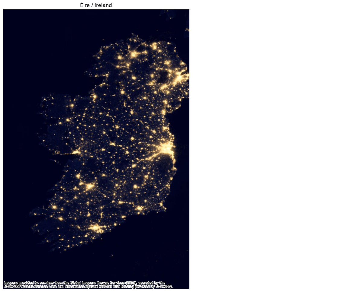
Store basemaps locally#
When you are working interactively, it is common to iterate over one visualisation several times and to have to combine several tools, not necessarily always Python. In these two situations, it is very handy if you don’t have to re-download a basemap every new iteration. contextily helps you with both.
First, in a given session, each tile is only downloaded once. Tiles are stored in a temporary cache so the next time you need it, you don’t have go to the web. This results in important time savings and network footprint.
[15]:
%time tempe = cx.Place("Tempe, AZ")
CPU times: user 796 ms, sys: 101 ms, total: 897 ms
Wall time: 6.1 s
[16]:
%time tempe = cx.Place("Tempe, AZ")
CPU times: user 7.41 ms, sys: 4.5 ms, total: 11.9 ms
Wall time: 95.8 ms
[17]:
tempe.plot()
[17]:
<AxesSubplot: title={'center': 'Tempe, Maricopa County, Arizona, United States'}, xlabel='X', ylabel='Y'>
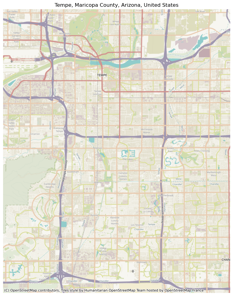
Second, contextily lets you download basemaps and store them in standard raster files that you can open back in Python, or in any other GIS. There are several ways to access this functionality. One is through the Places API:
[18]:
bristol = cx.Place("Bristol, UK", path="bristol.tif")
this downloads a basemap for Bristol and saves it to a file called bristol.tif, which you can access, for example, with rasterio:
[19]:
with rasterio.open("bristol.tif") as r:
    rioshow(r)
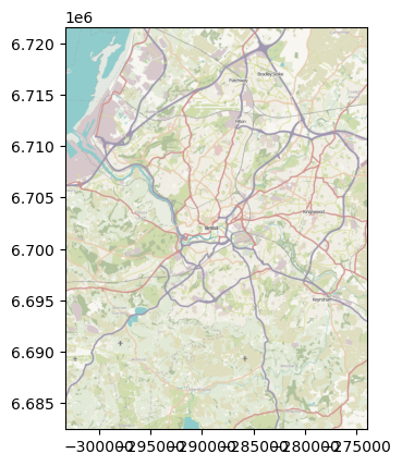
And you can also pull down basemaps using bounds2img’s sister method, bounds2raster, which works similarly:
[20]:
w, s, e, n = (-3.0816650390625,
              53.268087670237485,
             -2.7582550048828125,
              53.486002749115556)
_ = cx.bounds2raster(w, s, e, n,
                     ll=True,
                     path="liverpool.tif",
                     source=cx.providers.CartoDB.Positron
                    )
And view it equally:
[21]:
with rasterio.open("liverpool.tif") as r:
    rioshow(r)
Fine tune zoom levels#
Tile-based basemaps are provided at different zoom levels. Usually, contextily will automatically figure out an appropriate level so you don’t have to think about it. But sometimes, a user might want to fiddle with zoom levels on her own. For these tasks, the zoom parameter will be your friend.
For example, let’s return to the Ghent map:
[22]:
plt.imshow(ghent_img, extent=ghent_ext)
[22]:
<matplotlib.image.AxesImage at 0x1500bbd10>
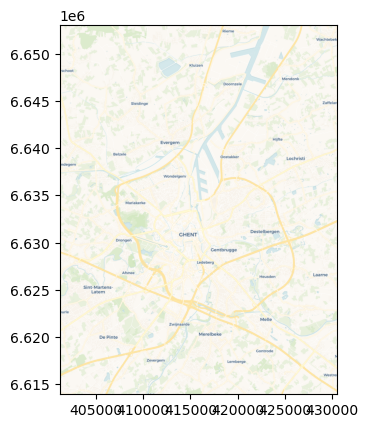
If we want a lower degree of resolution, maybe we can try level 10?
[31]:
ghent_img, ghent_ext = cx.bounds2img(west,
                                     south,
                                     east,
                                     north,
                                     ll=True,
                                     source=cx.providers.CartoDB.Voyager,
                                     zoom=10,
                                    )
plt.imshow(ghent_img, extent=ghent_ext)
[31]:
<matplotlib.image.AxesImage at 0x1535b5ad0>
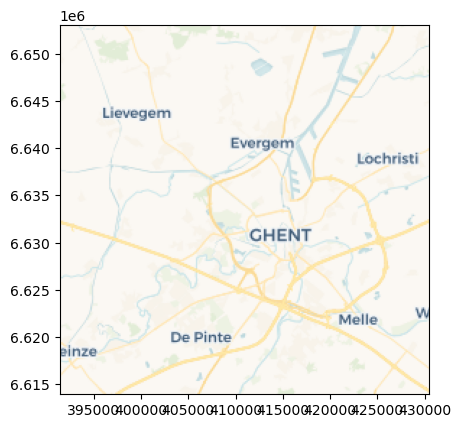
If you want to peak into the automatic level calculated, you can do it:
[24]:
cx.tile._calculate_zoom(w, s, e, n)
[24]:
12
Higher levels of resolution for the same extent involve more tiles being downloaded, which may take longer, so keep this in mind if you “bump up” the resolution. To check how many tiles need to be downloaded, you can use this other utility:
[25]:
cx.howmany(w, s, e, n, 13, ll=True)
Using zoom level 13, this will download 81 tiles
[25]:
81
[26]:
cx.howmany(w, s, e, n, 15, ll=True)
Using zoom level 15, this will download 1020 tiles
[26]:
1020
[27]:
cx.howmany(w, s, e, n, 10, ll=True)
Using zoom level 10, this will download 4 tiles
[27]:
4
Using transparent layers#
Sometimes, when you plot data on a basemap, the data will obscure some important map elements, such as labels, that you would otherwise want to see unobscured.
[28]:
df = geopandas.read_file(get_path('nybb')).to_crs(epsg=3857)
ax = df.plot(figsize=(9,9), color="none", edgecolor="r", linewidth=3)
cx.add_basemap(ax, crs=df.crs.to_string(), source=cx.providers.CartoDB.Positron)

Some map tile providers offer multiple sets of partially transparent tiles to solve this, and contextily will do its best to auto-detect these transparent layers and put them on top.
[29]:
ax = df.plot(figsize=(9,9), color="none", edgecolor="r", linewidth=3)
cx.add_basemap(ax, crs=df.crs.to_string(), source=cx.providers.CartoDB.Positron)
cx.add_basemap(ax, crs=df.crs.to_string(), source=cx.providers.CartoDB.PositronOnlyLabels)
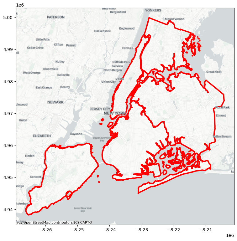
By splitting the layers like this, you can also independently manipulate the level of zoom on each layer, for example to make labels larger while still showing a lot of detail.
[30]:
ax = df.plot(figsize=(9,9), color="none", edgecolor="k", linewidth=4)
cx.add_basemap(ax, crs=df.crs.to_string(), source=cx.providers.CartoDB.Positron, zoom=12)
cx.add_basemap(ax, crs=df.crs.to_string(), source=cx.providers.CartoDB.PositronOnlyLabels, zoom=10)